File:Tah heatmap june2009.jpg
Jump to navigation
Jump to search


No higher resolution available.
Tah_heatmap_june2009.jpg (509 × 490 pixels, file size: 242 KB, MIME type: image/jpeg)
http://www.flickr.com/photos/stevefaeembra/3674760067/
This is a Featured image, which means that it has been identified as one of the best examples of OpenStreetMap mapping, or that it provides a useful illustration of the OpenStreetMap project. If you know another image of similar quality, you can nominate it on Featured image proposals.
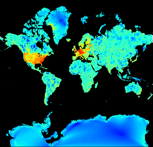
Front-page image for week 10 of 2010 (8–14 Mar.).
- Image descriptions
- Deutsch : Karten-Detailreichtum in der Welt (rot = komplexere Karten)
- English : Map detail throughout the world (red = more complex maps)
- español : Nivel de detalle en los mapas a nivel mundial ( rojo = mayor detalle )
- français : Niveau de détail représenté sur la carte mondiale (rouge = carte la plus complexe).
- italiano : Grado di dettaglio a livello mondiale (rosso = mappe più complesse)
- magyar : Térkép részletessége az egész világon (piros = részletesebb területek)
- Nederlands : Detail niveau op wereldvlak (rood = grote complexiteit).
- polski : Mapa zagęszczenia szczegółów w OpenStreetMap na świecie (kolor czerwony – bardzo szczegółowe mapy).
- português : Nível de detalhamento do mapa ao redor do mundo (vermelho = mapas mais complexos)
- suomi : Karttatieto on toistaiseksi epätasaisesti jakautunut maailmalla (Punaisilla alueilla eniten tietoa suhteessa alueeseen).
- русский : Детализация карты в масштабах планеты (красный цвет — наиболее полная карта)
File history
Click on a date/time to view the file as it appeared at that time.
| Date/Time | Thumbnail | Dimensions | User | Comment | |
|---|---|---|---|---|---|
| current | 14:10, 6 March 2010 | | 509 × 490 (242 KB) | Ojw (talk | contribs) |
You cannot overwrite this file.
File usage
The following file is a duplicate of this file (more details):
- File:Heatmap TAH 3 (3674760067).jpg from Wikimedia Commons
.jpg)
The following 6 pages use this file: