GpsVP
Jump to navigation
Jump to search
| gpsVP | ||||||||||||||||||||||||||||||||||||||||||||||||||||||||||||||||||||||||||||||||||||||||||||||||||||||||||||||||||||||||
|---|---|---|---|---|---|---|---|---|---|---|---|---|---|---|---|---|---|---|---|---|---|---|---|---|---|---|---|---|---|---|---|---|---|---|---|---|---|---|---|---|---|---|---|---|---|---|---|---|---|---|---|---|---|---|---|---|---|---|---|---|---|---|---|---|---|---|---|---|---|---|---|---|---|---|---|---|---|---|---|---|---|---|---|---|---|---|---|---|---|---|---|---|---|---|---|---|---|---|---|---|---|---|---|---|---|---|---|---|---|---|---|---|---|---|---|---|---|---|---|---|
 | ||||||||||||||||||||||||||||||||||||||||||||||||||||||||||||||||||||||||||||||||||||||||||||||||||||||||||||||||||||||||
| Author: | Vsevolod Shorin | |||||||||||||||||||||||||||||||||||||||||||||||||||||||||||||||||||||||||||||||||||||||||||||||||||||||||||||||||||||||
| License: | BSD | |||||||||||||||||||||||||||||||||||||||||||||||||||||||||||||||||||||||||||||||||||||||||||||||||||||||||||||||||||||||
| Platforms: | Windows and Windows Mobile | |||||||||||||||||||||||||||||||||||||||||||||||||||||||||||||||||||||||||||||||||||||||||||||||||||||||||||||||||||||||
| Status: | Unmaintained | |||||||||||||||||||||||||||||||||||||||||||||||||||||||||||||||||||||||||||||||||||||||||||||||||||||||||||||||||||||||
| Version: | 0.4.24 (2012-02-05) | |||||||||||||||||||||||||||||||||||||||||||||||||||||||||||||||||||||||||||||||||||||||||||||||||||||||||||||||||||||||
| Language: | multiple languages
| |||||||||||||||||||||||||||||||||||||||||||||||||||||||||||||||||||||||||||||||||||||||||||||||||||||||||||||||||||||||
| Website: | https://github.com/jerome077/gpsvp | |||||||||||||||||||||||||||||||||||||||||||||||||||||||||||||||||||||||||||||||||||||||||||||||||||||||||||||||||||||||
| Source code: | https://github.com/jerome077/gpsvp | |||||||||||||||||||||||||||||||||||||||||||||||||||||||||||||||||||||||||||||||||||||||||||||||||||||||||||||||||||||||
| Programming language: | C | |||||||||||||||||||||||||||||||||||||||||||||||||||||||||||||||||||||||||||||||||||||||||||||||||||||||||||||||||||||||
| ||||||||||||||||||||||||||||||||||||||||||||||||||||||||||||||||||||||||||||||||||||||||||||||||||||||||||||||||||||||||
GpsVP is a GPS enabled application that can display vector based maps and raster maps.
Licensed under New BSD License.
It has built in support for
- loading OpenStreetMap tiles (offline or on demand over wireless network, if you wish)
- and Garmin format maps (also more than one at a time), various levels of detail, POIs
- It can also record tracks and store POIs.
- a search in OSM is available
- scanned maps can be displayed, prerequisites: georeferenced, tiled, config files
- Map or monitors view
- Remap Hardware Buttons to functions
The application runs on the WIN32-platform (PCs) and on many PocketPC/Smartphones with and without touchscreen.
Offical website: http://code.google.com/p/gpsvp/
The track formats available are GPX or Oziexplorer (*.plt).
Version 0.4.24 as of February 5th, 2012
- ...
Version 0.4.20 as of March 2nd, 2010
- tracks: now uses GPS time (subsecond) instead of system time
- sun azimuth
- navigate along predefined route
Example of use
-
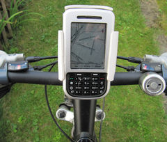 Ipaq mounted on bicycle
 -
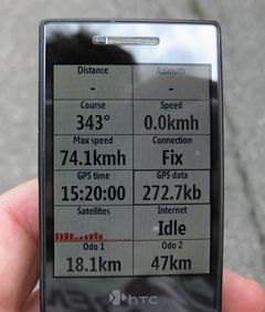 Monitors view on a HTC S740 Smartphone. For each box the parameter shown can be configured. One needs to go into the setup and choose some options to get this view.
 -
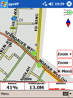 Vector map with marked cycle routes on pocket pc


Contact
Author?