JOSM/Plugins/AddrInterpolation
The JOSM Address Interpolation Plugin assists in the creation of interpolated addresses. See addr:interpolation=*
What is the Address Interpolation plugin?
The Address Interpolation described in the Karlsruhe Schema allows marking many house addresses with minimal effort using interpolation ways to create either individual house number nodes (most common) or (optionally) associated street relations.
Usage
Creating house number nodes only


The Address interpolation plugin is activated from a new entry created on the Data / Address interpolation menu. It is also assigned the hotkey ALT+Ctrl+Z by default.
The general workflow is to select the street and the new or existing Address Interpolation way, then invoke the Address Interpolation dialog.
(Note: New house number nodes will be equally spaced within the defined range. The nodes of this interpolation way are not considered at all when creating the house number nodes)
Here are the steps for a typical street:
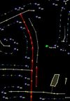
- Draw the Address interpolation way(s) as required for the street - shown selected in the image to the right. Be sure the Address Interpolation ways follow the numbering - start drawing in a direction from the lowest number towards the highest number.
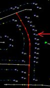
- After the ways have been drawn, select the street and an Address Interpolation way. Only one street and one address interpolation way can be selected as shown here.
- Invoke the plugin from the menu or hotkey.
- Enter the first and last house number in the dialog and check the box in the bottom to create the nodes.
- The interpolated way has now been replaced by house number nodes. Check that they all reside within the limits of a building.
Create associatedStreet relation (optionally)
If the street has an 'associatedStreet' relation, that relation will be suggested for associating with the address interpolation. Otherwise, it will associate using the street name. Enter the information to describe the address interpolation strip, then press OK to apply the parameters.
When moving to the "Numbering Scheme" field for the first time it attempts to auto-select the number scheme based on the numbers entered. If the auto detection was correct, just press ↵ Enter to save the screen choices. It may be necessary to change to "All" if both numbers were even or odd and the actual addressing scheme is 'all'. The auto detect only activates once to prevent changing a previous choice to an incorrect choice.
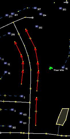
The new way will become an address interpolation way and be de-selected as shown here. The street remains selected - if there are more address interpolation ways, press ⇧ Shift+select to select a new way and the street, then repeat the process.
Altering existing house number nodes (optionally)
House number nodes (containing the key addr:housenumber) may be associated with a street by selecting them along with the street. Any numbered nodes in the middle of the Address Interpolation way will also be associated with the street. For these cases, there is an additional message : Will associate N additional house number nodes.
Survey accuracy
It is often not possible to gather 100 percent of house numbers during a survey due to missing numbers, etc. But the information from the surrounding houses is useful for navigation purposes. See detailed description.
- addr:inclusion=actual - Represents an accurate survey where calculating every house number from the address interpolation way results in an exact match with physical houses. In practice, if the all house numbers and end points are known, it would be better to convert to individual house numbers.
- addr:inclusion=estimate - The address interpolation way may contain numbers that don't actually physically exist. A survey has been performed, and Geo-location calculations will be within several physical house spaces from the actual house.
- addr:inclusion=potential - The complete range of all possible address numbers on a block, although there may not physically be enough room on the block for that range of house numbers. Interpolation data from US TIGER is an example where Geo-location would only be as near as one block.
Details on converting Address Interpolation way to individual house numbers
There's an optional checkbox to convert the address interpolation way to individual house numbers according to the addressing rules defined by the dialog. Note that there is no need to pre-create individual nodes - new nodes will be added as needed.
There may be house numbers already defined along the address interpolation way, for example:
10 ... 22b ... 30 .
House numbers that do not fit the addressing rules will be retained, but ignored for house number placement - 22b for this example. New housenumber nodes will be equally spaced within the defined range.
Predefined house numbers in the address interpolation way that do fit the addressing rules will be used as anchors.
For example: 10 ... 22 ... 30 .
House number 22 will be used as an anchor for physical placement, and new numbers will be equally spaced from 10-22, and 22-30; spacing may differ based on the location of the anchor house(s).
After new house numbers have been created, the Address Interpolation way and any untagged nodes will be deleted.
Tips
Before creating address interpolation ways, be sure that any associated streets do not contain abbreviations. This is particularly important if associating by street name and not by an 'associatedStreet' relation. The current or later upload with the Validator plugin will flag the abbreviated street names. After the street name abbreviation is corrected, and the addresses are not corrected, then the direct search for street name / address will fail.
How can I install the plugin?
Simply go to the Edit/Preferences menu, refresh the plugin list, and select the "Address Interpolation" option. You will have to restart JOSM afterwards.
Notes
Relations vs addr:street: This plugin supports both association by street name and 'associatedStreet' relation. Be aware that although the plugin makes working with associatedStreet relations much easier, it is still more difficult for humans to deal with relations than street names, particularly when using editors without the equivalent plugin.
Optional information: The "optional information" fields consisting of City, State, Post Code, etc are not normally required to geo-locate a house when city and region are defined by area boundaries. Because administrative boundaries are frequently redrawn, it is preferred to leave the optional fields blank so that it is not necessary to edit thousands of house number addressing details when administrative boundary lines move.
For the US only: TIGER addressing information will be imported or applied to the map in the future by some method. TIGER addressing data precision is restricted by law for privacy reasons to be only to within the nearest block. House numbering information gathered by first hand survey will be an improvement over TIGER data.
Known Problems
Automatic Postcodes The plugin assumes that all nodes containing optional information refer to the same information. Do not use this plugin on streets with house number nodes containing optional information and spanning multiple Post Codes / cities / countries.
Also be advised that, when you delete the postcode information in the plugin, it also deletes it from the selected nodes.
