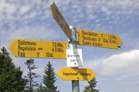
Key:direction_north
| Description |
|---|
| Directions on destination signs. |
| Group: properties |
| Used on these elements |
| Useful combination |
| Status: in use |
| Tools for this tag |
|
The keys like direction_north are used to add basic information about a guidepost. They are used to add the approximate direction of destinations shown and provide a simple way of tagging. More details can be added using either a relation of type=destination_sign, destination=* on ways, or the keys listed below.
This key was never formally proposed and discussed, but popped up in the German Wiki some years ago. In the meantime this group of keys is already used 95,000 times as of July 2023.
Tagging
Add a guidepost using the tags tourism=information and information=guidepost. Add the text on each of its fingers using one of the eight keys below. The values should be the text as shown on the sign. Multiple entries can be separated by ; (semicolon).
- direction_north
- direction_east
- direction_south
- direction_west
- direction_northeast
- direction_northwest
- direction_southeast
- direction_southwest
Note that the direction given can only be approximate and there is no direct connection with the way a guidepost points to. This information can be added using a relation with type=destination_sign.
Further details
In order to further specify the routes and symbols on a guidepost, subkeys such as direction_north:ref=* can be used. Currently in use are these keys:
| Key | Description |
|---|---|
| direction_north:ref=* | The reference number or acronym of the route shown on the sign. The value should match the one given by ref=* in the route relation. |
| direction_north:route=* | The full name of a route shown on the sign. The value should match the name given by name=* in the route relation. |
| direction_north:symbol=* | Symbols and icons next to named destinations. The values should be those that are listed in for the related tag destination:symbol=*. |
If there are several destinations and symbols on the same sign, they can be matched in he same way as it is done for destination tags: Both keys use ; separated lists which should have the same number of entries. Several symbols in one entry are separated by ,.
There is some discussion going on (in the German forum) how useful these extended tags, especially symbols, are. Some mappers prefer to put a reference to the symbol into the destination name itself, e.g. by replacing the symbol of a train station with the German abbreviation "(Bf)". This might be helpful to show the information in applications that don't support the extended tags yet, but is not as universal as the explicit tagging of a symbol.
Example
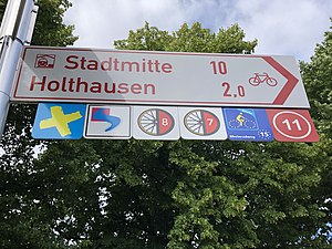
To tag the guidepost finger on the right, which points northwest, use the tags
- tourism=information + information=guidepost + bicycle=yes
- direction_northwest=(Bf) Stadtmitte 10 km;Holthausen 2.0 km
- direction_northwest:route=Euroga Radwege;Erlebnisweg Rheinschiene;Rhein-Route;Pilgerroute;Rheinradweg;11 or
direction_northwest:ref=Eu;ERS;D8;D7;EV15;11 - direction_northwest:symbol=train_station;none
See e.g. DE:Bicycle/Fahrradroutensammlungen for the names and refs of cycle routes in Germany.
Maps that Show direction_* Tags
- OsmAnd lists the values tagged under direction_*=* keys when a guidepost is selected on the map. Pull up on the information panel or click "Details" to see them.
- waymarkedtrails.org also lists the values when a guidepost is selected. Click "Destinations" in the side panel to view the list with helpful arrows.
See also
- information=guidepost - for an overview of different ways to tag destinations.

