Key:mindistance
 |
| Description |
|---|
| Minimum allowed distance between two vehicles traveling along the road. |
| Group: restrictions |
| Used on these elements |
| Useful combination |
|
| See also |
| Status: in use |
| Tools for this tag |
|
The minimum legal distance that a driver must maintain between their vehicle and the vehicle in front when driving along a roadway. This legal restriction may also apply when traffic is at a standstill.
Where to find them
Minimum distance restrictions are most commonly found on bridges or in tunnels. A minimum distance can protect a bridge from damage caused by two heavy vehicles spaced too closely together. A minimum distance restriction can mitigate the risk of fire spreading in a tunnel. Both the Vienna Convention on Road Signs and Signals and the Manual on Uniform Traffic Control Devices specify standard signs for indicating these restrictions.
These restrictions are essentially specific prohibitions against tailgating. However, it is not necessary to tag the minimum distance on every road in a jurisdiction that happens to have a law about maintaining assured clear distance ahead. Only tag a minimum distance restriction where it is specifically applied to a certain road (especially if it is signposted), irrespective of the driving rules in that jurisdiction.
How to map them
Tag the roadway subject to the restriction with mindistance=##, where ## is the minimum number of meters on the sign, for example mindistance=50 for a 50-metre (160 ft) minimum distance. In regions that measure road distances in non-metric units, specify the unit explicitly, for example mindistance=30'6" for a 30-foot-6-inch (9.30 m) minimum distance.
Minimum distances on bridges usually only apply to certain kinds of vehicles. Use mindistance:hgv=* instead of mindistance=* to limit the restriction to trucks.
If a different restriction applies depending on the direction of travel along the roadway, append :forward or :backward to the key as appropriate.
Examples

Vienna Convention:
mindistance=70
Cyprus:
mindistance:hgv=70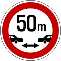
South Korea:
mindistance=50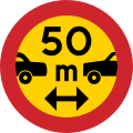
Sweden:
mindistance=50
United States (Ohio):
mindistance:hgv=30'![United Kingdom: mindistance=80 (each chevron is spaced 40 m apart)[1]](https://upload.wikimedia.org/wikipedia/commons/thumb/8/87/UK_traffic_sign_2933.svg/125px-UK_traffic_sign_2933.svg.png)
United Kingdom:
mindistance=80
(each chevron is spaced 40 m apart)[1]


![United Kingdom: mindistance=80 (each chevron is spaced 40 m apart)[1]](/wiki/File:UK_traffic_sign_2933.svg)
Statistics
mindistance:hgv=
See also
- Relation:enforcement + enforcement=mindistance - permanently installed devices that measure and document traffic violations, such as mindistance
References
- ↑ “Traffic Signs Manual: Road Markings” (PDF). Department for Transport. pp. 110–111. “Chevrons are placed at intervals of 40 m, ensuring that a safe distance is kept between vehicles travelling at 70 mph as long as drivers keep a minimum of two chevrons apart.”