Proposal:City wall
| City wall | |
|---|---|
| Proposal status: | Obsoleted (inactive) |
| Proposed by: | * |
| Tagging: | man_made=city_wall |
| Statistics: |
|
| RFC start: | 2008-01-04 |
this seems to be obsoleted by the approval of barrier=* (=city_wall).
- There is currently also mapnik rendering rules for historic=citywalls. -- Dieterdreist 08:34, 2 July 2010 (UTC)
man_made = city_wall
A linear feature for city walls.
Includes historical walls and modern walls (Baghdad Green Zone's wall, the West Bank barrier etc.)
Rendering
Thick black dashed line or black line with dashed inside edge (subject to figuring out how to do this in osmarender )

Discussion
- I'm ok with the value, but I don't particularly like the man_made key. I think this could go fine under the key I proposed some while ago, which is border=, as the wall definitely a border. Ben. 01:23, 9 March 2007 (UTC)
- I'm not sure that a city wall must be a border. For example while London Wall may have been a border 200 years ago it isn't now (although I think the remaining sections are significant enough to be included in OSM.) Tjpayne 16:47, 9 March 2007 (UTC)
- border refers to physical things, rather than political boundaries. Political boundaries are currently under the 'Place' key. London wall is still London 'wall' regardless of its current use. In places it still obstructs, and for that reason it is still a border, just like a fence, or a hedge. The tourism, and Place keys can go along side where necessary, but for just a wall, I think it's a border value. If a wall was no longer there at all, then maybe it would have to go under historic, assuming it was justified as being necessary to map.Ben. 00:11, 10 March 2007 (UTC)
- My preference would be for man_made - if I go there, I expect to see something significant; border= would also work as defined as something physical, though I'm a bit uneasy that it will be confused with things like country boundaries. If the wall is also a political boundary, then the way can also be tagged appropriately. MikeCollinson 00:41, 18 March 2007 (UTC)
- FYI, the Intramuros walls, old Spanish city walls here in Manila, are shown on a local map in a thick casselated brown. It looks quite attractive. MikeCollinson 00:41, 18 March 2007 (UTC)
In the case of London, would there be any intent to show the line of the wall in areas where it no longer physically exists? If so, are you intending to differentiate? MikeCollinson 00:41, 18 March 2007 (UTC)
- I could see the simple broken line indicating the parts where it used to exist. That is in the example drawing the upper left half would be the existing wall, the lower right half would be the destroyed/former location of the wall. --Hawke 23:53, 11 June 2007 (BST)
- That makes sense to me ... we will need some extra tagging to indicate "former line of" city wall. I'm trying to think of an easy and logical way, any ideas? MikeCollinson 07:58, 4 January 2008 (UTC)
- We could simply use border=former_city_wall, couldn't we?
From a different angle, what about other bits of wall? For example in Veralamium Park in St Albans there is a small bit of Roman Wall left standing (the locals demolished the rest to build the Cathedral ;-). It's hardly a border, but I've made it border=city_wall with historic=ruins and "name=Roman Wall" for now. TomChance 16:13, 21 March 2007 (UTC)
- * It is "hardly a border" but it is in the physical sense, as you can't walk threw it, and it once was in the political sense, and thats why it was originally built. I would agree with those tags you used though. I agree that border and political borders may be confused, but I think thats just because of the multiple uses of the word in English, rather than border being the incorrect term to be used for physical dividing features. Ben. 19:45, 21 March 2007 (UTC)
- Border sounds like the more correct key to me as well. How do the towers on the wall get tagged? --Polyglot 07:57, 1 February 2008 (UTC)
- I'm wondering why I would map something that does not exist and has no use anymore ...?? And how would I get the data ? The ruins of an old wall can of course be mapped and tagged as historic. --PhilippeP 09:17, 1 February 2008 (UTC)
- For all walls of the past, ruin or not (Hadrian Wall, middle age cities, Berlin wall, etc..) I would prefer historic=wall (period=roman, greek, hellenistic, etc.), and for those still in active duty, something like military=wall or fence --Gummibaerli 18:32, 8 February 2008 (UTC)
- I don't agree with Gummibaerli's definition because active duty is hard to define. Any historic wall that is still complete (e.g. medieval city wall) is on one hand historic but is still a border that cannot be crossed besides it's gates. But the military function is in most of the cases neglectable for hundreds of years. Here in Rome there are different citywalls of different historic periods and even more gates. I consider the man_made=city_wall key as appropriate, but I like Gummibaerli's idea for period=roman, or even more precise Constantin, Hadrian, baroque, etc. How could we put gates in the walls? I propose to tag segments with the additional keys (gate=yes, layer=1), just like we tag bridges with streets. The Gates would surely have names (at least the historic ones) and be lots of times also historic monuments of touristic attraction (with sculptural features). therefore it would be helpful to add information like name=xy, period as mentioned before by Gummibaerli could also be applied on these segments, as it may differ from the wall --dieterdreist 17:17, 21 February 2008 + 27 March 2008(UTC)
- We could also represent gates as nodes in which the wall and another way intersect, which is what usually happens in the reality. I agree in marking the name of the gates and the period of the walls, but I would suggest also to being more precise about it including also the year or the century (period_year=1250 or period_century=XIII). --G.mascellani 10:56, 24 July 2008 (UTC)
- My personal opinion on city_wall describes something of ancient build wall of defense. But what about any new build walls which just have the sense of supporting some steep breakup of different heights. (don't know if this is the right english description? - Just meaning prevention of moving ground, when the height difference within some meters is as heigh as about 10 or more meters) Those supporting walls may be of actual dates be build and are a very clear sign of visual confirmation of positioning. --Michael 00:08, 7 April 2008 (BST)
- I don't like restricting this to city walls, what about walls like those around old castles and fortresses? I'd suggest man_made=wall instead. Bobkare 19:08, 16 June 2008 (UTC)
- prisons are also walled ;) --Cbm 09:46, 20 June 2008 (UTC)
- i agree with bobkare, man_made=wall is more flexible. Also i think we need the gate property. But not sure how to handle complex ways like this one http://www.flickr.com/photos/orlok/68471232/ cross by a footway and a highway, with a footway in the top and internal steps joining the two footways PerroVerd 12:02, 14 August 2008 (UTC)
- I agree with Bobkare. I would prefer to tag any wall as such and maybe add some additional tags to specify it as a city wall. I don't like the man_made key. I suggest to merge this with the proposal for a barrier key. In the talk page for barrier Cbm suggested to use this for walls. The barrier proposal page already describes tagging a way with barrier=bollards for a line of bollards. So I suggest barrier=wall. Bomm 07:33, 18 August 2008 (UTC)
- I think it is important, to show somehow, if the wall can be used as a way or not. Here in Ulm we have a rather new city wall (from about 19th century), parts of which are a really popular footway (about 2-3m wide on top of the wall). How can such a wall be distinguished from a wall that is only a landmark for orientation but not relevant for routing? I think it would be a good idea to see such a wall as an area (like building=yes) and to draw a way on top of it - but this is not possible if the wall is only seen as a line. --Kalauer 09:42, 26 July 2008 (UTC)
- I think, there should be a (great) difference between medieval city walls, the Berlin Wall and the Baghdad Wall. Mediaeval city walls and today the tiny rest of Berlin Wall are cultural heritage and mostly attractions for tourists, which you can pass if you want. You can go for to take a picture ore something else. Modern "city walls" are so called separation barriers, which you cant compare with the others: http://en.wikipedia.org/wiki/Separation_barrier
So I like to make 2 proposals: historic=city_wall and man_made=separation_barrier. Krtek76 20:06, 25 September 2008 (UTC)
- nice point here there is difference. so there should be a tag for them. In the barrier=* line it could be:
- · barrier=city_wall ; tourism=yes ; historic=yes ; name=Old Medieval Wall
- · barrier=separation_barrier ; tourism=yes ; historic=yes ; name=Berlin Wall
- · barrier=separation_barrier ; name=Baghdad Wall
- --Sergionaranja 08:43, 26 September 2008 (UTC)
Rendering
It might be impossible for a renderer to distinguish which is the internal and which is the external side in case of incomplete / partially demolished city walls, so the proposed rendering can't do dashes on the inner side, solid line on the outer. I propose it is always rendered as solid line with a dashed line just above it (adjacent, on the northern side) --Stefanb 15:57, 12 June 2007 (BST)
- Just as the renderer currently knows that water is at the right hand side of segments with coastlines we could agree that the walls are drawn clock-wise. In this sense, the inner side of the wall would be the right side of the segment (or additionally allow for a wall-direction=-1 or something if that is not possible, a la the oneway=-1 tag). So renderers can know what the inside and what the outside is. --spaetz 19:55, 12 June 2007 (BST)
- I don´t think there is a need for wall direction tags. Just render a line with the dashed side thing allways at the right (or left, but allways the same). Then the side is just a matter of direction of the way. it doesen´t matter either, if is closed or not, it will work for both.--Sergionaranja 18:38, 31 July 2008 (UTC)
i think rendering should go like this:
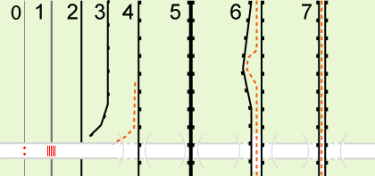
- 0 barrier (barrier=hedge) at the crossing way (highway=residential) at the crossing way node (barrier=bollards)
- 1 barrier (barrier=fence) at the crossing way (highway=residential) at the crossing way node (barrier=cattle_grid)
- 2 barrier (barrier=wall) at the crossing way (highway=residential) at the crossing way node nothing
- 3 barrier (barrier=retaining_wall) should never cross a way
- 4 barrier (barrier=city_wall) at the crossing way (highway=*,layer=-1) at the crossing way node nothing
- 5 barrier (barrier=city_wall;two_sided=yes) at the crossing way (highway=residential;tunnel=yes;layer=-1) at the crossing way node nothing
- 6 2 separate barriers (barrier=city_wall) at the top way (highway=footpath) at the crossing way (highway=*,layer=-1) at the crossing way node nothing
- 7 barrier and footway share same way (highway=footpath;barrier=city_wall) at the crossing way (highway=*,layer=-1) at the crossing way node nothing

- just in cases 1 and 2 there is shared node.
- both sides of the wall are at same level in 1, 2 and 5.
- a way is at top level inside the wall in 6 and 7
- i think this tag should be merged to Proposed_features/barriers
- --Sergionaranja 15:29, 16 September 2008 (UTC)
- no way, it's far more than that. You are neglecting historical importance, in general they are of high cultural value, if they would just be barriers, you could also map all other things like buildings, rivers, whatever as barriers.
- I like parts of the proposed rendering though. The thicker parts (rectangles) should not be rendered senseless but represent in general defense towers or similar structures of the wall (areas where the wall extents it's width). This could be a tag on nodes (at least as long as the structure isn't mapped as an area, which in most cases IMHO would make sense.) There are also gates still missing. Unless the wall is build on top of an embankment the tunnel is IMHO not the right representation (or say it like this: when there is no tunnel, that passes underneath the wall (what is theoretically possible), there should be a gate-solution).
- -- Dieterdreist 20:15, 10 December 2008 (UTC)
- You are getting emotional! We are just mapping objects and barrier is a good key to store that value in, the historical importance does not matter. Tag the wall with a Wikipedia-Link if it is important! --Phobie 21:11, 10 December 2008 (UTC)
- I think youre missing the point. It's not about being emotional or sentimental but rather if we're talking about a streetmap or a general map database. Of course background articles and definitions/documentation are available on wikipedia (and I think intelligent linking would be nice), but a logical scheme, that is not limited to a "streetmap"-point-of-view, will help us to structure the data. Barrier is too generic if you comprise everything that hinders your movement, therefore I would prefer to limit it's use to traffic obstacles (where I don't count city walls in the first place). Dieterdreist 00:40, 11 December 2008 (UTC)
- Barrier is for things built/created specifically and only to prohibit movement, not for any physical object. Barrier is generic, hence it's the key, the specifics are within the value. I see far less need for it in traffic obstacles as the most common versions such as hedges and fences. A city wall is a barrier, and maybe a tourist attraction also. I agree to your point that it's a streetmap or a general map database, and tagging a city wall as more than a barrier or tourist attraction would be seeing OSM as a visual encyclopaedia rather than a map, labelling the wall not relative to its status and place on the landscape, but for other reasons that don't really belong on a map. Manmade on the other hand is about as generic as you can get. I therefore agree to the merger proposal.Ben 11:02, 11 December 2008 (UTC)
- I think youre missing the point. It's not about being emotional or sentimental but rather if we're talking about a streetmap or a general map database. Of course background articles and definitions/documentation are available on wikipedia (and I think intelligent linking would be nice), but a logical scheme, that is not limited to a "streetmap"-point-of-view, will help us to structure the data. Barrier is too generic if you comprise everything that hinders your movement, therefore I would prefer to limit it's use to traffic obstacles (where I don't count city walls in the first place). Dieterdreist 00:40, 11 December 2008 (UTC)
- You are getting emotional! We are just mapping objects and barrier is a good key to store that value in, the historical importance does not matter. Tag the wall with a Wikipedia-Link if it is important! --Phobie 21:11, 10 December 2008 (UTC)