Tag:building=transformer_tower
Jump to navigation
Jump to search
 |
| Description |
|---|
| A small but tall building constructed to comprise a transformer and connect to an overhead power line. |
| Rendering in OSM Carto |

|
| Group: buildings |
| Used on these elements |
| Useful combination |
|
| Status: de facto |
| Tools for this tag |
|
The tag building=transformer_tower represents a tall building specially designed to connect to an overhead medium voltage power line (power=minor_line) and to house a small substation with a distribution transformer. Often, the power line has been dismantled and replaced by an underground cable. However, the building may still be in use as a substation.
How to map
Map the building and add the tag building=transformer_tower.
If the building is still in use as a substation then it should also get the following tags:
- power=substation
- substation=minor_distribution
- voltage=* (if the voltages are known, e.g. voltage=20000;400)
Other optional tags:
- operator=* (the name of the power company)
- ref=*, name=* (any reference number or name the power company may use to refer to this substation)
Example
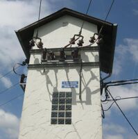
Transformer tower in Germany
building=transformer_tower
power=substation
substation=minor_distribution

See also
- power=substation Tagging of substation properties and substation components like transformers.