Tag:cemetery=cillín
 |
| Description |
|---|
| A disused burial ground mostly for unbaptized children in Ireland. |
| Group: landuse |
| Used on these elements |
| Status: in use |
| Tools for this tag |
|
A cillín (Anglicized killeen; Irish plural cillíní, English plural killeens) is a burial site for unbaptized children, sometimes also other people who were not allowed to be buried in consecrated ground or whose religion was not known. These burial grounds are found all over Ireland in rural areas. People in the past used disused graveyards, ringforts and other places they considered in some way sacred for these burials.
The name derives from the diminutive for "church"/ "cell" - cill.
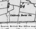
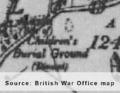
Some cillíní can be found in the British War Office map as "Children's Burial Ground" or "Burial Ground for Infants". Sometimes the knowledge about their location is handed down in field names or other place names like Killeen/ Cillín or Cnocán na Leanbh (=Hillock of the Babies). Sometimes, a "monument tree" can be found on the site which can also be mapped.
Tagging scheme
cemetery=cillín
disused=yes
source=*
Optional tags
name=*
historic=archaeological_site + site_type=necropolis
description=*
ref:IE:smr=* (for the reference no. of the National Monuments Service)
Gallery

Lisheen
Cillín in Killinny, Co. Clare
Cillín in Kilcomeragh, Co. Waterford


