Tag:cycleway=asl
Jump to navigation
Jump to search
 |
| Description |
|---|
| On-road Advanced Stop Line for cyclists |
| Group: cycleways |
| Used on these elements |
| Useful combination |
| Status: de facto |
| Tools for this tag |
|

A cycleway ![]() advanced stop line (ASL), also known as a bike box or an advanced stop box, is a marked area for cyclists in front of the stop line for motor traffic. They are most commonly found at traffic-light controlled junctions and allow cyclists a head start when the traffic signal changes from red to green[1].
advanced stop line (ASL), also known as a bike box or an advanced stop box, is a marked area for cyclists in front of the stop line for motor traffic. They are most commonly found at traffic-light controlled junctions and allow cyclists a head start when the traffic signal changes from red to green[1].
Usage

- Create a new
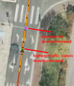
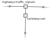
 a few metres way back from the junction node, ideally level with the stop line at the front of the painted box.
 - If it is not a oneway the a direction tag is needed. Use key direction=* for this. Values are forward or backward. Example: direction=forward
Example

Do not tag the junction node itself: this is misleading because then nobody can tell which direction of approach the ASL applies to.
Further Information
Rationale and status
- These cycle facilities are common sights in UK cities and places like Portland, Oregon, USA. Junctions using them should be tagged, since their presence may be informative for cycle routing.
- "Advanced Stop Line" is the British English term for these facilities. "Bike box" is also documented here, but Wikipedia prefers the former.
- Abbreviations are short and sometimes easy to remember.
- Status:
 De facto I suppose, but pretty uncommon. This is the most common way in the database of representing this type of bicycle facility as the time of writing, [2]
Routing and data model
No fancy relation is necessary, which keeps things simple for mappers. ASL nodes are always connected to their junctions by the way they're on. Find the nearest highway junction node along the way it's on, and that gives you both the associated junction and the applicable direction.
Open issues
- Feeder (cycle) lane vs not?
- ASLs for other types of vehicle. Are there any?
References
- ↑ http://en.wikipedia.org/wiki/Advanced_stop_line
- ↑ TagInfo as of 2011-04-09: 14 for this combination vs. cycleway=bike_box with 1, and cycleway=advanced_stop_line with 1 also. It's not much to go on, I know!