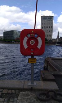
Tag:emergency=life_ring
Jump to navigation
Jump to search
| Description |
|---|
| A floating ring to throw out to someone who is struggling in water. |
| Group: emergencies |
| Used on these elements |
| Useful combination |
| Status: in use |
| Tools for this tag |
|
An emergency flotation device that is thrown to a person in need, usually attached by rope so the device can be pulled back. Often found beside more popular water courses, reservoirs, beaches, lakes etc.
- See Lifebuoy on Wikipedia
How to map
Place a ![]() node at the storage place of the life ring and add emergency=life_ring.
node at the storage place of the life ring and add emergency=life_ring.
Tags used in combination
- ref=* - a reference identifier
- support=* - How is the ring supported/anchored
- operator=* - Who owns and maintains the ring?
- colour=* - What colour is the ring?
Support
- support=pole The ring is mounted on a pole.
- support=pillar The ring is mounted on a pillar or column.
- support=wall_mounted The ring is mounted to a wall.
- support=fence The ring is mounted to a fence.
Rendering
No known rendering on OSM website.
Icon
![]() as seen in iD editor.
as seen in iD editor.
Life ring images
See also
- emergency=throw_bag a rope (in a bag) that can be thrown to a person in the water.
- emergency=rescue_buoy like a life ring, but a buoy on the rope instead.


