Tag:hazard=landslide
Jump to navigation
Jump to search
.jpg) |
| Description |
|---|
| An area where landslides, mudslides or rockslides are known to occur. |
| Group: hazards |
| Used on these elements |
| Useful combination |
|
| See also |
| Status: approved |
| Tools for this tag |
|
A landslide hazard is an area where landslides, mudslides or rockslides are known to occur. This typically are posted along mountain roads or paths.
How to map
Landslide hazards may be mapped in the following ways:
- Place a node
 at the location of the landslide hazard sign, tagged traffic_sign=hazard + hazard=landslide.
 - Tag a node along a highway=* way
 at the location of the sign.
 - If the landslide warning sign indicates a distance, tag the section of highway=* where the landslide hazard is present.
Examples

UK landslide warning sign

Hong Kong landslide warning sign
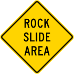
United States rock slide warning sign


Possible tagging mistakes
See also