Tag:man_made=dyke
Jump to navigation
Jump to search
 |
| Description |
|---|
| An embankment built to restrict the flow of water or other liquids |
| Group: man made |
| Used on these elements |
| Useful combination |
|
| See also |
| Status: de facto |
| Tools for this tag |
|
An embankment built to restrict the flow of water or other liquids. Also known as a levee.
How to map
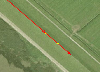
Draw a way ![]() along the top of the dike. This is often seen on aerial photographs at the transition between sun and shade. Tag this with man_made=dyke. Optionally, if the dike has a name, you can add this with name=*.
along the top of the dike. This is often seen on aerial photographs at the transition between sun and shade. Tag this with man_made=dyke. Optionally, if the dike has a name, you can add this with name=*.
If there is a road/path or railway on top of the dyke, draw the highway or railway and use embankment=dyke instead.

For closable openings in the dyke, for example for a road or railway, see the tag barrier=coupure. The opening can be closed with for example a door, metal bars or sand(bags)

See also
- man_made=embankment - Raised bank which often carries a road, rail or waterway
- embankment=yes - A generic value for embankments
- embankment=dyke - To be used if there is a highway or road on top of the dyke. Use this instead of man_made=dyke
- waterway=dam - A wall built across a river cross-flow direction
- man_made=breakwater - breakwater is a structure surrounded by water
- Proposed features/Dyke (abandoned)