UK 24 hour mapathons/Aug 2019 Wansbeck
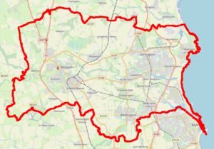
The August 2019 24-hour mapathon will occur on Sunday 11th August. Wansbeck is a UK parliamentary constituency and is an area of Northumberland(map) that includes Morpeth, Ashington, Bedlington, and Newbiggin-by-the-sea. Morpeth is easy to reach by train, and could be a focus (especially for house numbers).
There are several ways to organise what we do, the main way is to see if we can have at least one person active (mapping remotely or on-the-ground) for every hour of the day.
Please edit this page, sign up to say if/where/what you might focus on. If you want to get in touch with someone you can contact Gregory through OSM Messages or on Twitter.
| Hour (start) | Names | Activities/intentions |
|---|---|---|
| pre-work | LastGrape/Gregory | Location undecided, can get street-level photography probably on Saturday. |
| midnight | Example | Example |
| 1 am | Example | Example |
| ... | ... | ... |
| 2 pm | LastGrape/Gregory | Probably Morpeth for a few hours. More imagery or my own mapping. |
| 3 pm | Example | Example |
| ... | ... | ... |
| 10 pm | Example | Example |
| 11 pm | Example person Another mapper |
Example activity Another activity |
Areas to consider
- House numbers (see Cramlington for example)
- Any missing footpaths?
- New housing developments (can anyone gather a list/locations?)
- LastGrape/Gregory might focus on this
- Look at construction sites on Overpass for sites that might be complete.
- Blossom Park, Barratt Homes, near Hebron Avenue, Pegswood - unknown if work has started.
- The Fairways, Linden Homes, South end of Morpeth - unknown if work has started.
- Map rooftop solar panels to coincide with the quarterly project. Wansbeck has 1279 to map (although Morpeth is not included in that area)
- Potential cafe/pub to meet in if people in-person want to meet at some point in the day.
Remote Mapping
Later this will be a list of things that can be done by remote-only mappers, such as links to street-level imagery. If you're interested, sign up for an hour(s) when you plan to be online/available, or add your name here.
- Gather a list of new housing developments/locations.
Before the Mapathon
These statistics are as of, thanks to the data download from Geofabrik. If anyone is interested in mapping specific themes then I can try and extract other stats.
Keys and number of occurrences...
  19813 building
   5656 highway
   4010 name
   1777 barrier
   1292 landuse
    804 power
    773 addr:street
    748 amenity
    402 natural
    388 addr:housenumber
    341 shop
    278 lanes
    215 route
    204 fhrs:id
    186 leisure
    161 waterway
    149 bicycle
    114 sport
    100 bridge
     96 man_made
     77 wikidata
     54 entrance
     51 tourism
     43 construction
     32 wheelchair
     19 historic
Top values for highway=
   2210 residential
   1145 service
    724 footway
    247 primary
    185 unclassified
    177 track
    150 tertiary
    117 path
    109 secondary
     99 cycleway
     82 trunk
     62 steps
I may remove this section after the mapthon, as the next section will likely show the changes.
After the Mapathon
Add here any statistics, comments, blog posts, tweets, etc. Let us know what you did!
