User:Minh Nguyen/destination:street
| Key:destination:street | |
|---|---|
| Proposal status: | Draft (under way) |
| Proposed by: | Minh Nguyen |
| Tagging: | destination:street=* |
| Applies to: | |
| Definition: | Supplemental road name that accompanies a route shield on a guide sign |
| Statistics: |
|
| Rendered as: | Hidden |
| Draft started: | 2017-10-17 |
This is a proposal for a new destination:street=* tag for supplemental road names[1] that appear on freeway guide signs. This proposal builds on Proposed features/Destination details. It aims to address shortcomings in the definition for destination:street=* that was originally proposed in Exit Info and recently added to Proposed features/Destination details.
Proposal

destination:street=* contains a supplemental road name that accompanies a route shield on a guide sign at the beginning of a link road (such as at a motorway junction).
In some U.S. states, it is standard practice to accompany a route shield with the associated road name on guide signage. Supplemental road names are included to aid local motorists who are more familiar with the road name than the route number. They are not considered primary destinations.
A primary destination is placed beneath the route shield in full-size lettering. By contrast, a supplemental road name is placed to the right of the route shield, similar to a cardinal direction. A supplemental road name is usually set in small type, sometimes in fine print.
Use destination=* for a road name that appears as a primary destination, with the same prominent presentation that a place name typically receives. Do not assume that destination=* necessarily names the road to which the link road directly leads.
As with other destination:*=* tags, variations such as destination:street:lanes=* and destination:street:forward=* may occur in some cases.
Rationale
Routing software may include the supplemental road name in destination:street=* in turn instructions for informational purposes, as space or time allows. For example, a tool that renders realistic-looking guide sign diagrams[2] may use this tag to display the supplemental road name in the style described above. On the other hand, real-time turn-by-turn instructions may omit the supplemental road name if the maneuver location is imminent and not enough time is available to read the destination sign in full. The supplemental road name may also be omitted on a second or third reading of an instruction. This is in contrast to any road names in the destination=* tag, which are to be given the same prominence as any place names in that tag.
Relevant standards
In the United States, the national Manual of Uniform Traffic Control Devices discourages indicating both a road name and a city name as destinations on the same guide sign,[3] but it allows supplementing a route shield with the road name.[4][5] Some states commonly display these supplemental road names wherever locals are more likely to know the highway name than the route number. To avoid information overload,[6] these supplemental road names are laid out differently than ordinary destinations: they appear to the right of a route shield in a smaller font. The details vary by state:
- In Kentucky, KYTC has standardized supplemental road names in its Traffic Guidance Operations Manual (TO-404-36). The road name is set in all capital letters at the same size as a cardinal direction. It is only included if space allows, the road is maintained by the state, and the name does not indicate a commercial or industrial establishment.
- In Maryland, the State Highway Administration has standardized supplemental road names in Maryland Standard Highway Signs. Compare sign D3-2(4) with the road name to sign D3-2(3) with the cardinal direction. The road name is set in title case at a slightly smaller size than the main destinations. It may be left, center, or right aligned. In some cases, there is no destination besides the shield and accompanying road name.
- In Massachusetts, MassDOT's Guide Sign Policy for Secondary State Highways is silent on the issue of road names next to route shields. The road name is set in all capital letters at the same size as a cardinal direction and center aligned.
- In Tennessee, TennDOT's Supplemental Rules for Guide Signs on Freeways, Expressways and Conventional Highways appears to proscribe supplemental road names on guide signs, yet examples include guide signs to Saturn Parkway.
In other states, road names rarely appear with route shields on guide signs, but when they do, they are presented as ordinary destinations, not as supplemental information. This proposal does not address such signs.
A distinction between supplemental road names and other destination road names appears to be peculiar to the MUTCD as implemented in these states. Countries that adhere to the Vienna Convention on Road Signs and Signals are unlikely to need the proposed tag; all road names can go into destination=* without losing information about the names' prominence.
Examples
Road names are signposted beside route shields on guide signs in at least the following states:
- Supplemental road names on guide signs
Florida
junction:ref=10A
destination:ref=US 29 South
destination:street=Pensacola Boulevard
destination=Pensacola
Florida
junction:ref=337
destination:ref=I 295
destination:street=Beltway
destination=Orange Park;Jacksonville Beaches
Illinois
junction:ref=53C
destination:ref=I 55 North
destination:street=Stevenson Expressway
destination=Lake Shore Drive;22nd Street
Kentucky
junction:ref=189
destination:ref=KY 1072
destination:street=Kyles Lane
destination=Fort Wright;Park Hills
Maryland
junction:ref=6
destination:ref=MD 170
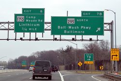
destination:street=Camp Meade Road
destination=Linthicum
Maryland
junction:ref=29
destination:ref=MD 193
destination:street=University Boulevard
destination=Wheaton;Langley Park
Maryland
junction:ref=13
destination:ref=MD 650
destination:street=New Hampshire Avenue
destination=White Oak;Ashton
Massachusetts
junction:ref=46
destination:ref=MA 213
destination:street=Loop Connector
destination=Mathuen;Haverhill
New York
junction:ref=26W
destination:street=Winchester Avenue West
destination:ref:to=I 287 West
destination=White Plains
Pennsylvania
junction:ref=31;131
destination:ref=I 476 North
destination:street=Northeast Extension
destination=Allentown
Tennessee
junction:ref=5B
destination:ref=US 51 South
destination:street=Elvis Presley Boulevard
destination=Graceland;West Brooks Road
Virginia
junction:ref=44
destination:ref=VA 193
destination:street=Georgetown Pike
destination=Langley;Great Falls, Virginia


.jpg)
.jpg)
_at_Exit_7B_(Maryland_State_Route_295_NORTH-Baltimore-Washington_Parkway,_Baltimore)_in_Linthicum,_Anne_Arundel_County,_Maryland.jpg)
_at_Exit_29_(Maryland_State_Route_193-University_Boulevard,_Wheaton,_Langley_Park)_on_the_edge_of_Silver_Spring_and_Four_Corners,_Maryland.jpg)
_at_Exit_13_(Maryland_State_Route_650-New_Hampshire_Avenue,_White_Oak,_Ashton)_on_the_edge_of_Colesville_and_Cloverly_in_Montgomery_County,_Maryland.jpg)


_at_Exit_44_(Virginia_State_Route_193-Georgetown_Pike,_Langley,_Great_Falls_Va)_in_McLean,_Fairfax_County,_Virginia.jpg)
![]() More examples at Wikimedia Commons
More examples at Wikimedia Commons
Tagging
The destination:street=* tag is to be used in conjunction with tags such as destination=*, destination:ref=*, destination:symbol=*, etc.
Applies to
Ways, especially ways tagged highway=motorway_link or highway=trunk_link.
Rendering
This tag would not be rendered by a general-purpose map renderer.
Features and pages affected
Alternatives considered
All streets in destination:street
Exit Info proposes to use destination:street=* or destination:street:to=* for any street on a guide sign.[7] Valhalla uses this tag to distinguish between streets and place names in instructions, such as "Take exit 6B on the right onto MD 170 South/Camp Meade Road toward Linthicum" (emphasis added). [1]
This approach fails to distinguish destination road names from supplemental road names. As explained above, it is not always necessary to include a supplemental road name in a guidance instruction, especially on the instruction's second or third reading. destination:*:to=* should be reserved for cases where "To" is present on signage, because it should also be safe to omit these destinations when necessary.
Most importantly, pulling road names out of the list in destination=* assumes that road names always come before place names on signage.[8] Yet guide signs not infrequently list a place before a street, usually due to a subsequent fork. As of 2021, there are at least 1,207 cases in OpenStreetMap in which destination=* contains a road name after a place name.[9]
Incorrectly guessing the sign order will cause a router to list the destinations in reverse order, making it more likely that a motorist would miss an exit looking for the wrong name. The following examples illustrate Valhalla's behavior given tagging that adheres to Exit Info:
- Instructions giving priority to more obscure text

California
"Take the exit on the right onto Mathilda Avenue South toward Sunnyvale"
California
"Take the exit on the right onto Chadbourne Road toward CA 80 East/Sacramento/Fairfield Auto Mall"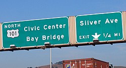
California
"Keep left onto US 101 North toward Bay Bridge/Civic Center"
Connecticut
"Take exit 87 on the right onto Brainard Road toward Airport Road/Brainard"
Illinois
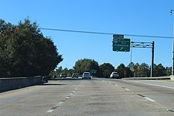
"Take exit 53 on the right onto I 55/Stevenson Expressway toward Lake Shore Drive/Saint Louis"![Ohio "Keep left onto I 71 North/US 50 East toward I 471/Columbia Parkway/Columbus"[10]](https://upload.wikimedia.org/wikipedia/commons/thumb/5/5a/Westbound_U.S._Route_50_at_Interstate_71_-_Mapillary_%28Ja8waY4E35V7PEYQ2VKBUw%29.jpg/250px-Westbound_U.S._Route_50_at_Interstate_71_-_Mapillary_%28Ja8waY4E35V7PEYQ2VKBUw%29.jpg)
Ohio
"Keep left onto I 71 North/US 50 East toward I 471/Columbia Parkway/Columbus"[10]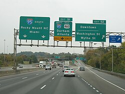
Virginia
"Take exit 52 on the right onto Washington Street/Wythe Street toward Downtown"
.jpg)


.jpg)
![Ohio "Keep left onto I 71 North/US 50 East toward I 471/Columbia Parkway/Columbus"[10]](/wiki/File:Westbound_U.S._Route_50_at_Interstate_71_-_Mapillary_(Ja8waY4E35V7PEYQ2VKBUw).jpg)

- California:
- Take the ramp on the right onto US 101 North/Old Middlefield Road toward San Francisco [2] – Old Middlefield Road does not lead to San Francisco.
- Take the exit on the right onto McDonnell Road toward International Terminal – McDonnell Road does not lead to the International Terminal.
- Ohio:
Valhalla tends to make other incorrect assumptions about the road layout when optimizing for an overly specific sentence structure. These road layouts could conceivably be expressed in other ways, such as using destination:ref:to=* and destination:via=*, but those tags would contradict what's signposted on the ground, for reasons that would not be apparent to the user at the moment when the destination tags are most relevant:
- Ohio:
- Take exit 104 on the right onto SR 104/Frank Rd – The implication is that SR 104 is Frank Road, but in fact Frank Road leads to SR 104.
- Pennsylvania:
- Take exit 65 on the right onto PA 50 toward Carnegie/Heidelberg – The exit leads to a series of unnumbered surface streets before reaching PA 50.
Migration
Even though quite a few non-supplemental road names are currently tagged as destination:street=*, existing routing software can transition smoothly to the new definition with little or no change.
OSRM
OSRM uses destination:street=* as a fallback when destination=* is missing. If destination=* is present, destination:street=* is omitted. Under this proposal, OSRM will produce more accurate instructions in cases where standard road name destinations are currently tagged as destination:street=*. The following examples illustrate what would happen to OSRM's output, assuming no software changes:
- Changes to OSRM instructions in the absence of software changes
Road name destination with shield
Old: "Take exit 78, on the right, toward MD 295 North: Baltimore"
New: "Take exit 78, on the right, toward MD 295 North: Baltimore-Washington Parkway"Road name after place name
Unchanged: "Keep right at the fork onto US 101 North: Civic Center"Supplemental road name
Unchanged: "Take exit 189, on the right, toward KY 1072: Fort Wright"

Valhalla
Valhalla currently produces instructions like "Take exit junction:ref=* on the right onto destination:ref=* (destination:street=*) toward destination:ref:to=*/destination:street:to=*/destination=*". As discussed above, this approach can produce suboptimal instructions. The following examples illustrate what would happen to Valhalla's output, assuming no software changes, as ways are retagged from the scheme described in Exit Info to the scheme proposed here:
- Changes to Valhalla instructions in the absence of software changes
Road name destination with shield
Old: "Take exit 78 on the right onto MD 295 North/Baltimore-Washington Parkway toward Baltimore"
New: "Take exit 78 on the right onto MD 295 North toward Baltimore-Washington Parkway/Baltimore"Road name after place name
Old: "Keep left onto US 101 North toward Bay Bridge/Civic Center"
New: "Keep left onto US 101 North toward Civic Center/Bay Bridge"Supplemental road name
Unchanged: "Take exit 189 on the right onto KY 1072/Kyles Lane toward Fort Wright/Park Hills"
tbd
Notes
- ↑ To my knowledge, there is no official name for this phenomenon, but it is widespread enough to warrant a tag.
- ↑ Such as CheckAutopista.
- ↑ “Manual on Uniform Traffic Control Devices”. Washington, D.C.: Federal Highway Administration. December 19, 2023. p. 301.
- ↑ “Manual on Uniform Traffic Control Devices”. Washington, D.C.: Federal Highway Administration. December 19, 2023. p. 290.
- ↑ “Manual on Uniform Traffic Control Devices”. Washington, D.C.: Federal Highway Administration. December 19, 2023. p. 272.
- ↑ roadfro, "Re: city names on freeway signs", AARoads Forum.
- ↑ These tags were first added to Exit Info in 2015 but did not go through the tag approval process. At that time, there were no occurrences of either tag. The first occurrences appeared within a month in Pennsylvania and Maryland. It was added to Proposed features/Destination details in October 2017.
- ↑ A tagging list thread from January 2017 discusses the problems with this assumption.
- ↑ This is a very naïve search that can only detect when a road with a prefix like "Road" or "Avenue" occurs after a single-word destination, which is unlikely to be a street name. However, it fails to account for multi-word place names, which are also quite common. It is also unknown how many cases there are among ways that have been tagged with destination:street=* according to the proposal in Exit Info.
- ↑ Note that southbound I-71/I-75 does not lead to Second Street, and neither does Second Street lead to I-71/I-75.