WikiProject Ethiopia
| V・T・E |
| latitude: 7.4, longitude: 39.9 |
| Browse map of Ethiopia 7°24′00.00″ N, 39°54′00.00″ E |
| Edit map |
|
External links:
|
| Use this template for your locality |
Ethiopia is a Country in Africa at latitude 7°24′00.00″ North, longitude 39°54′00.00″ East.
Welcome to the OpenStreetMap Project Ethiopia!
Communications channels
Imagery availability
In May 2017 Digital Globe made their Premium imagery available for OSM use. The coverage is better than Bing, however, alignment may be off in places. Make sure to compare DG imagery with GPS traces. An additional challenge of using DG Premium is that the date of image collection is not readily apparent.
Most of Ethiopia has 2011-2013 Bing imagery with many exceptions.
An over view can be found here: https://ant.dev.openstreetmap.org/bingimageanalyzer/
Boundary
Key:boundary#Admin_level_values_for_specific_countries Boundary tagging for Ethiopia
please see the comment on talk page.
see also: WikiProject_Nile
Data Import
- DEPHA - has granted us (Development Seed) - permission to upload their base layers - roads, rails, admin boundaries. Outstanding work includes:
- Roads
- Rails
- Rivers
- Admin Boundaries (need to determine current status of OSM dataset before doing anything here)
Monitoring
There is a weekly report about the changes in Ethiopia on http://downloads.ethiopia-map.com/qa/osmdiff/
Tagging
Streetnames
- name - Contains the Name as seen on the street sign.
- name:am - Contains the Amharic name as seen on the street sign
- loc_name - (Optional) Contains the local name. For example in Addis Ababa, many roads have common names. Africa Ave is known by many people as "Bole Road". Many Roads are referenced to because of embassies or big companies which are located there: EU Road, Bole-Ruwanda, Tele-Bole Road
see also: Key:name see also: http://www.loc.gov/standards/iso639-2/php/code_list.php for other language codes
Church Forests
Forests surrounding Ethiopian Orthodox Tewahedo Churches should have the following tags.
Light
Use the tag "lit=yes" - as many streets in Addis Ababa do not have lights.
Status
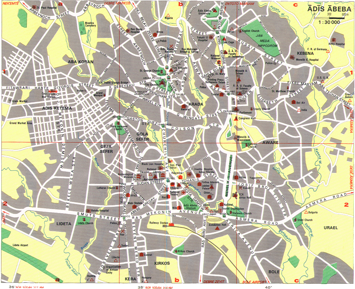
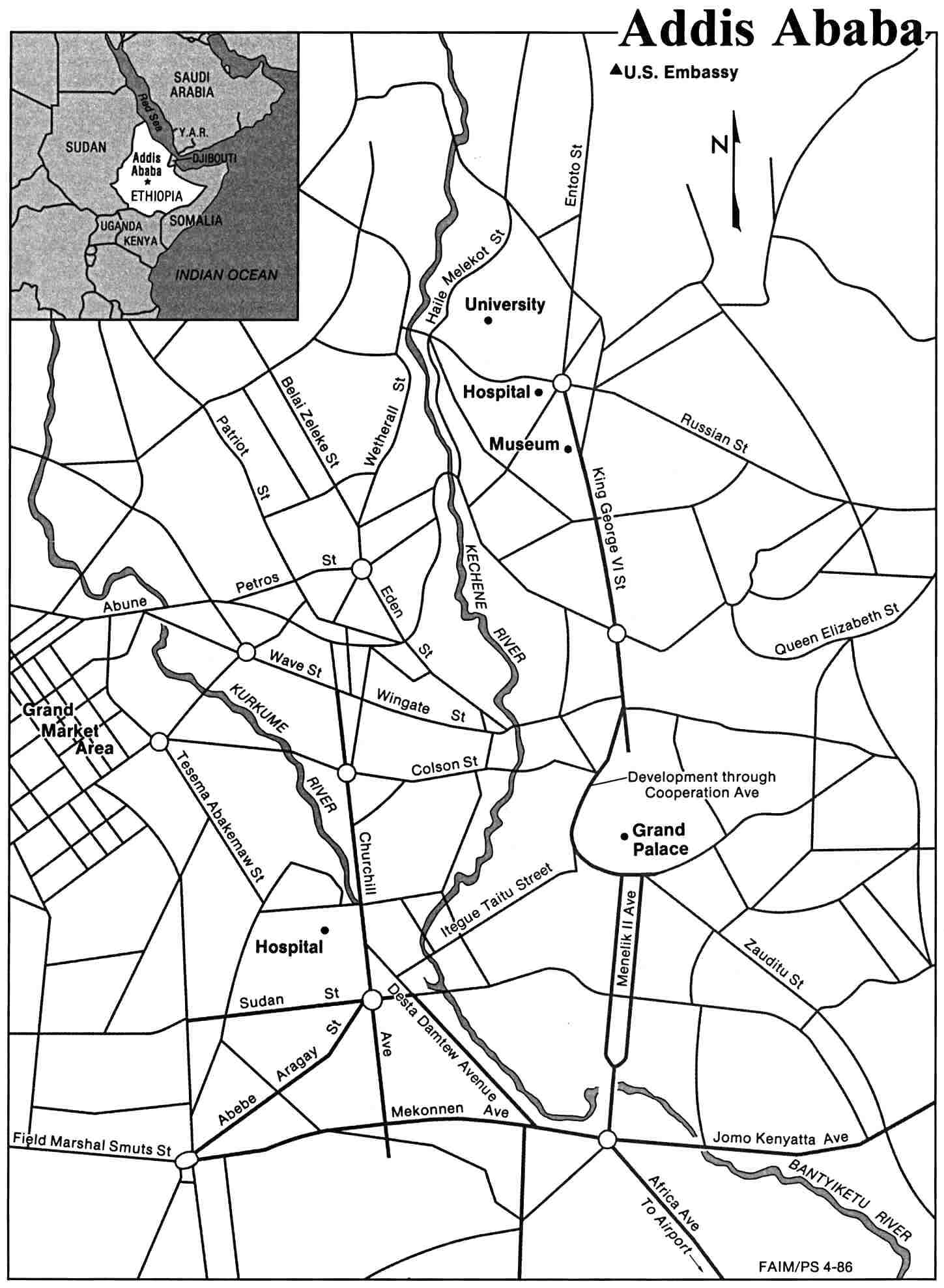
Addis Ababa: Main Roads, many Names Missing - OSM Map
- Bole Homes: Done
Quality control
Sources
CNS
Import cities from CNS: WikiProject_Ethiopia/GNS Problem: Cities are not classified by size.
Worldgazetteer
Allowed ? I asked for permission --Alexm 07:40, 23 July 2008 (UTC)
gdata
The also have roads .. [1]
In mapcenter there is a Map in garmin format generated from this [2]
Addis Ababa subcities
On http://www.addisababacity.gov.et/ the shapes of subcities can be found. I will try to use this as a base for addis ababa. I tried to put the subcities sketch on openstreetmap - does somebody have information about the borders?? Is Ethio-Chinese-Road the North border to bole ?
http://self.mestrona.net/blog/wp-content/uploads/2008/07/g3372.png
Tag Guidelines
- What about minibuss-lines ?
Community Channels
- Talk list: https://lists.openstreetmap.org/listinfo/talk-et
- Twitter:
 @osm_ethiopia
 - Ethiopia OSM Forum: https://forum.openstreetmap.org/viewforum.php?id=88
Involved People
The current contributions to Ethiopia can be found here: http://osmstats.neis-one.org/?item=countries&country=Ethiopia
Thank you very much to Pascal Neis for his great work to summarize OSM contributions
- Flor - I have started to trace some of the main streets in Addis from Yahoo. I've only been in Addis for 2 months so I only remember some of the areas well. For these areas I intend to put as much detail in as I can. Apart from that I would like to improve some of the existing ways and make them more consistent (bridges, junctions, road classification etc). I'm not so good with names of things but at least I can add things and others could correct or add names.
- Sandfuchs - I have more or less finalized Bole Rwanda area. Worked on the south-western and eastern part of the Ring Rd up to Maganagna Roundabout. Added many Street Names.
- Zulumap - Done some major changes to Ring Road between Bole Homes and Megenagna Roundabout. Done some changes to 'confusion square' but not completed yet. Modified various roads and made them double carriage ways. Added various POIs. I am using OSMTracker to log GPS tracks with my Windows Mobile phone and then update the maps using Merkaartor.
- Alazar I am working for Addismap.com and I am 24 years old.
- Alex Little I'm a VSO volunteer working at Mekelle University. I'm now beginning to map Mekelle.
- Diego Guidotti - I started to import DEPHA data in the south of Ethiopia (Yabelo-Moyale) I am in Addis until the first week of August, I am trying to add new POIs
- UNGSC-DTLM-Ale_Zena Hello, we would like to start some mapping projects in the Northern part (Mekelle - Auxum - Adigrat). I have an Ethiopian colleague, with some local links, very interested in grow a local community. Let me know if you are interested in join to.
References
- Amharic GeoNames @ amharic.org as of 12.11.2007
- http://www.africa.upenn.edu/Map_Satellite/Addis_Ababa_19465.gif -- is this map compatible to the OSM Licence ???
- Addis Ababa U.S. Dept. of State 1986 (157K) - http://www.lib.utexas.edu/maps/world_cities/addisaba.jpg -- is this map compatible to the OSM Licence ??
- Maps of Ethiopia: http://www.lib.utexas.edu/maps/ethiopia.html -- check licenses !!!
- https://wiki.openstreetmap.org/index.php/Potential_Datasources#GEOnet_Names_Server -there is a file containing many towns - check if they are a good source - how can it be imported ??