Gaza Strip
| V・T・E |
| latitude: 31.41, longitude: 34.39 |
| Browse map of Gaza Strip 31°24′36.00″ N, 34°23′24.00″ E |
| Edit map |
|
External links:
|
| Use this template for your locality |
Gaza Strip is a territory in Palestine at latitude 31°24′36.00″ North, longitude 34°23′24.00″ East.


Gaza Strip mapping project is focused on rapidly increasing the level of mapping available in the area for humanitarian relief efforts and other purposes. Detailed information about the region is available in the Gaza Strip/Region article.
See also Palestine
- North Gaza Governorate==
4731200![]() 4731200
4731200
- Gaza Governorate==
3935814![]() 3935814
3935814
- Deir el-Balah Governorate==
4731198![]() 4731198
4731198
- Khan Yunis Governorate==
4731199![]() 4731199
4731199
- Rafah Governorate==
4731201![]() 4731201
4731201
The current dataset
DATA: daily data dumps are available as .osm and .shp files from http://download.geofabrik.de/osm/asia/ (thanks to Frederik Ramm). There may be issues with the fonts in the shapefiles. Gaza is based on the admin boundary and Gaza-bbox is a slightly larger rectangle (Lat 31.18, Lon 34.17; Lat 31.62, Lon 34.60).
Routing
Routing is possible in the area using your navigation although that only works with mapnik at present.
EU
The EC Joint Research Centre provides the base map data for the UN OCHA maps of the Gaza Strip. The data is available for download here for non-commercial, non-modifiable use .. which excepts OSM of course, but it may still be useful elsewhere.
First-hand information sources
We're seeking contacts with first-hand knowledge of Gaza. Please add any leads below. If you attempt contact, please make a note here.
- Wikipedians working on relevant articles
- See Wikipedia section above
- The 'Palestinian' quarter of the town you live in. Why not print out the and current map and go and ask in the cafes for people to draw on it in the areas they know, come back and enter it in OSM.
- Sheffield PSC contacted - they are 'friends' with a prominent Rafah Blogger
- Any suitable events?
- Staff at UN agencies
- Staff with NGOs in Gaza
NGOs
CHF International published a VILLAGE SERVICES PROGRAM in 2004. It show details the administrative sections of South Gaza (from the El-Qarra entry point to the Egyptian border) on page 27 although some of the information seems old. It also lists various NGO's operating in the Rafah/Khan Younis region as at August 2004. Some crossing points shown have changed.
UN
The United Nations Relief and Works Agency for Palestine Refugees in the Near East and UN Office for the Coordination of Humanitarian Affairs published a Humanitarian Needs Assessment document in June 2004. It shows various suburbs of Rafah on page 20 but still shows settlements and check-points which were removed after in 2005. The map is based in information available in 2004 and the base mapping is 2002. There appears to be no copyright message anywhere in the document.
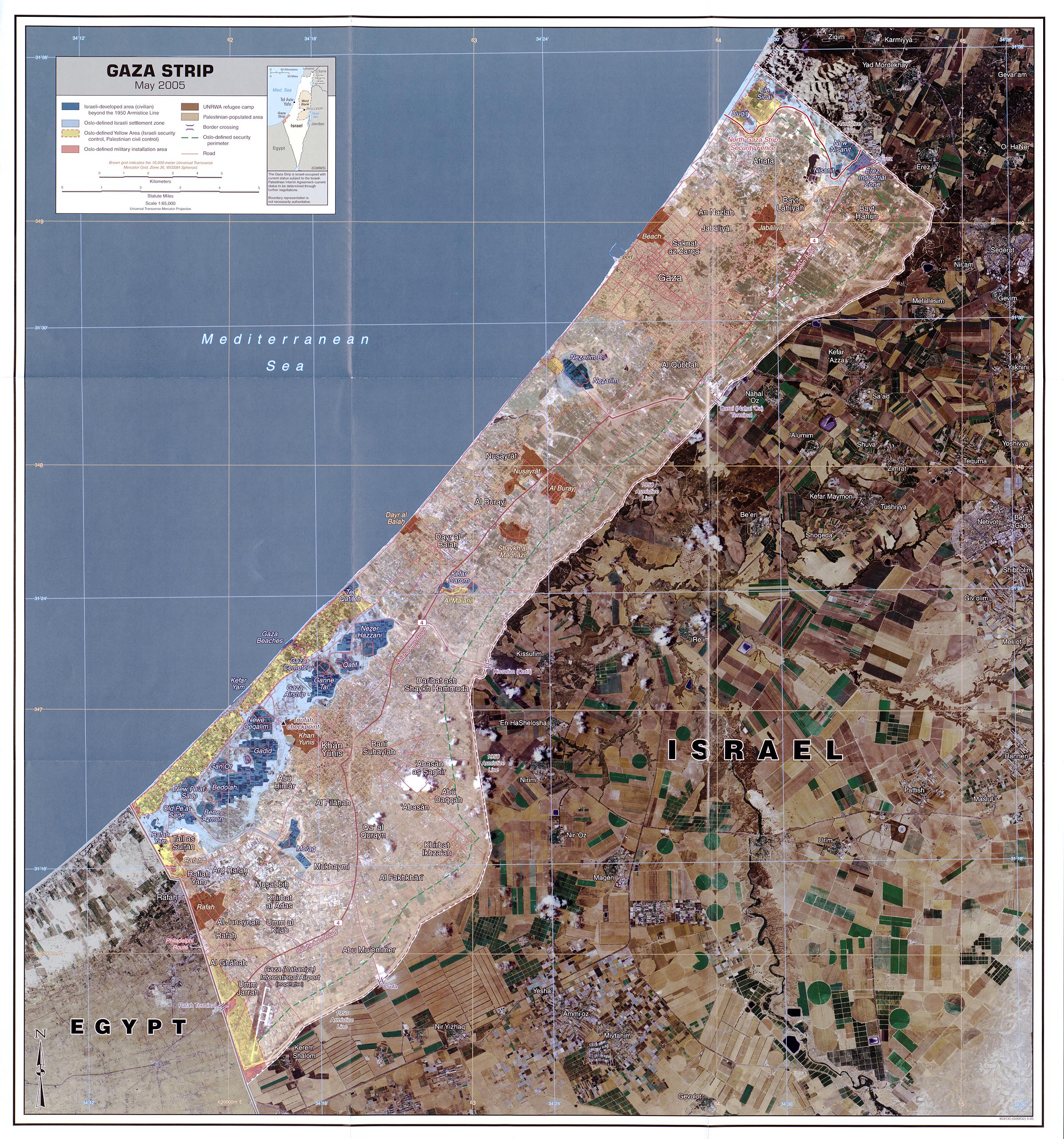
This map shows the locations and extents of some 79 Palestinian settlements and neighborhoods in the Gaza Strip
USA
The US Central Intelligence Agency (CIA) published a map in 2005 showing settlements, camps, major roads and various borders over a high quality aerial photography. There is no mention of copyright on the document. It is therefore probably a good source of names - I can't imagine the CIA suing OSM for using a document that didn't have a (c) message on it. However there are some errors and confusions. The name Rafah appears four times on the map, once in Egypt in the position of the now closed Canada camp and once in the position of the main town of Rafah (although sources vary about where this should be). It also appears twice to identify camps, once in the position of the current Rafah Camp but also as a section of Tall as Sultan.
Works of the US Government are usually public domain: Copyright status of work by the U.S. government
note: the rest of the USA related links appear to be broken geocoded LANDSAT ETM+ satellite maps, GeoTIFF with 15m panchromatic channel
- http://glcfapp.umiacs.umd.edu:8080/esdi/previewList?granule_id=17324
- http://glcfapp.umiacs.umd.edu:8080/esdi/previewList?granule_id=37264
- http://glcfapp.umiacs.umd.edu:8080/esdi/previewList?granule_id=37340
- http://glcfapp.umiacs.umd.edu:8080/esdi/previewList?granule_id=43848
Naval Research Labs GIDB Portal publishes Israel eMaps WMS with (roads, imagery, many different layers). The data claims to be free of restrictions in usage, but probably isn't. The many different layers rely on you reading Hebrew to know which is useful (the first layer isn't at all useful and disagrees with border location, presumably some others are more useful and up to date)
Wikipedia
Information from Wikipedia can be used in OpenStreetMap, but do check the references to ensure that Wikipedia ia actually right. If you find an error you might like to correct it or at least make a note here.
- Category:Buildings and Structures in the Gaza Strip
- Category:Gaza Strip
- Gaza Strip
- Gaza Strip Barrier
- Governorates of the Palestinian National Authority
World Health Organisation
The WHO have an interactive map of all hospitals and clinics. The information is marked copyright (c) World Health Organisation.
Other
- Old Soviet maps for download http://maps.poehali.org/en/. copyright ok??
- Geonames .. http://www.geonames.org/maps/google_31.5_34.467.html .. data is possibly derived from copyright sources but Geonames is often used without question, especially if it matches up to some other source
See [[Talk:Gaza#Level_of_Detail Level of detail] discussion on the talk page.
Regions
Information on the region is now being collected in Palestine_Gaza/Region. Existing content has been moved there.
Discussion
All questions/discussions are now hosted on Talk:Gaza.
- User:jhellen - I'm able to use ArcGIS or AutoCAD if needed
Is your organisation is in Gaza and does it want this to happen? If you do then: Add your comment and contact details here (you will need to register on the wiki to edit it)
- See also 2014 Gaza Strip.
- See also Gaza War (2008–09)
Links
- Ed Parsons post highlighting OpenStreetMap Gaza
- Aidworker daily post comparing differing mapping sources for the Gaza Strip
- A message of support from the Caribbean
- iGaza Map The Tourist Map has been published!
| ||||||