Yahoo! Aerial Imagery

- About
- Yahoo!'s vertical aerial photographs were used between 2007 and 2011 to trace maps and accurately create maps in some parts of the world. It was also allowed to use the imagery in Potlatch 1 and formerly standalone OpenStreetMap editors.
- Impact on OpenStreetMap
- We were able to trace from yahoo to more quickly and accurately create maps in some parts of the world, and we are very grateful to Yahoo! for this support during the crucial early years of our project's development between 2007 and 2011.
- Reason for being historic
- In September 2011 Yahoo partially shut down their aerial imagery service and/or replaced their imagery with such from a new source.[1] There is a similar agreement with Bing (Microsoft) which is superior on the whole, but not everywhere. Cities in Pakistan for example were covered by the no-longer-available Yahoo imagery, but are not available (at hi res) in Bing.
- Captured time
- 2016, 2019 (#Coverage), 2011 (#Accuracy)

WE DO NOT HAVE PERMISSION TO USE ANY CURRENT YAHOO IMAGERY!
Yahoo! never exactly gave us explicit permission, but stated that their terms and conditions allow using their aerial imagery (blog announcement about it) for the purposes of tracing. We could use any of the three main OSM editors (Potlatch, Merkaartor, or JOSM), to edit OSM map data over the Yahoo! imagery. Further back in history, it was originally brought into the Java Applet editor.
Achievements
The availability of the Yahoo! imagery made possible a number of tasks which would most be almost impossible without it. Some of these achievements are listed here:
The whole of the original London Congestion Charging Zone was mapped over a single weekend by a team of people using Yahoo! imagery. London is notoriously difficult to map using conventional GPS-based methods due to the urban corridor effect giving poor traces.

- Baghdad maps
The whole road and rail network of the Baghdad area has been mapped using the Yahoo! imagery. As have some parks, forested areas, etc. People on the street are showing real interest in filling in the road names to make this an actually useful map, it's not just a promotion piece.
- Mashhad, Iran
The whole road and rail network of the Mashhad, Iran area has been mapped using the Yahoo! imagery. As have some parks, forested areas, etc. Street and place names are slowly coming in as well. A GPS-track was used to verify that the Yahoo! imagery indeed was accurate and has very little (<2m) offset in that area
- St Albans and surrounding area
Not quite so grand as the above cases, but every last bit of woodland, every golf course, every lake and the main rivers/streams/lakes were mapped, which isn't possible with Landsat and would be very laborious by ground-based surveys.
- Sydney and surrounding area
Completion of the greater metropolitan railway network, completion of the inner city unclassified road network, many arterial major roads that were previously in as stretches here and there, several complex road interchanges not practical to map on the bike, several major rivers (also strangely difficult to map on a bike) and adjusted many problems due to inner city urban canyoning. Plus a good few golf courses, parks and sports pitches. At the AU$160/km² rate quoted for Australian 2m resolution imagery, that would have cost AU$300,000.
- Darwin to Port Augusta (Australia)
Using the new Potlatch editor the highway between Darwin and Port Augusta (i.e. the whole of the central North - South Highway), together with the highway to Ayers Rock & the Olgas, has been completed. Most of the imagery is low resolution. (The road has now been surveyed along stretches and has been nudged and tagged accordingly.)
Coverage
There used to be a long list of places covered. The following examples display former coverage in and around agglomerations.
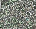
Yahoo! Aerial Imagery presented within the Java Applet editor in 2007 (with early OSM data overlaid)
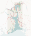
Around Oslo, Norway
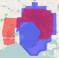
Coverage of Yahoo! (blue) compared to NearMap (red) round Melbourne and Geelong, Australia


Accuracy
- Main article: Using Imagery
Yahoo!'s aerial imagery is pretty accurate. More so than consumer GPS units in general. In some parts of the world (e.g. Italy) there is noticeable offset though, much more than simple consumer GPS units.
Every imagery source has a limit to its accuracy, and Yahoo imagery is no exception, however consumer grade GPS units certainly have accuracy limits too. If you think you have discovered an area where yahoo imagery is offset from reality, please bear in mind first of all that it is actually far more likely that one GPS trace is wrong! Consumer GPS units will often record tracks with an offset from reality. Recording several tracks on different occasions might allow you to diagnose a yahoo accuracy problem however. You shouldn't ignore this, but try to move to yahoo imagery in the editor to better suit the recorded tracks and existing data.
This generally is not a high priority problem to try and tackle. Initially when looking at mapping an area, it is fine to assume that the Yahoo imagery is placed accurately (as long as there is not already mapping data and GPS-traces in OSM to verify against), and there's lots of work to do, in the U.S. for example, lining up TIGER data with Yahoo.
Mapping with an offset
We could aim to use multiple GPS readings to determine what offset Yahoo imagery has, and it's worth noting that local people may have already attempted this. If you are looking at an area which has already had some work done on it, you should probably think twice before moving all the roads onto the yahoo imagery.
The idea is to use your GPS traces, and any other GPS traces uploaded in the area. If there are several of them along the same road, and the traces seem trustworthy (for example: no significant wobbling on straight roads) then supposedly you have found that Yahoo imagery is offset. At this point you can then re-align the imagery layer onto those traces as follows:
- In Potlatch you can move the background by holding space and dragging the background
- In JOSM you can move the image layer by selecting it and choosing the Adjust tool
 : then drag the imagery to fit the traces.
Examples of inaccurately placed yahoo imagery
Please link examples here. Link to the Potlatch edit view, where we can see the imagery and then show your GPS tracks (Upload them) You should have several GPS tracks recorded on different occasions.
- Bern, Switzerland 39509794
 39509794 https://www.openstreetmap.org/edit?lat=46.83817&lon=7.65331&zoom=17 https://www.openstreetmap.org/edit?lat=52.2445&lon=1.2913&zoom=13
Legalities
Note that as of late 2011, Yahoo have shut down their mapping unit. The following does not apply to any new yahoo offerings and new editing activity within OSM. The details are kept here for historical interest, and because the nature of these past agreements is pertinent to existing OpenStreetMap data.
Yahoo took the position that if we derive vector-based map data from the aerial photos owned by Yahoo! they are no longer copyright Yahoo!, so we could release our data under any license we want, CC-BY-SA, ODbL, ... Anyone who has traced from Yahoo imagery may accept our new contributor terms and does not have to change their contributions.
We were permitted to display the aerial photos alongside our data in Potlatch and the Java Applet (and any other online mapping tools).
We were also permitted to use plug-ins within JOSM as of 13th July 2007[2]. Similar uses within other off-line mapping tools also were likely to be permitted.
Yahoo's last statement on the legalities, from Scott Regan, was..
On the usage of our Aerials API, again I can reiterate that the OSM's usage of the free API for overlaying GPS and tracings appears to be well within the terms of use.
To address some other questions that have been raised, we don't see any red flags with the GPX files overlays approach that is used by OSM community members vs. our restriction on plotting real time GPS coordinates or points that are less than 6 hours old. And the other question regarding the mechanics of how imagery is cached in a transient manner by the OSM tracing app also does not violate the constraint preventing the capture of individual images for commercial purposes. Again, our assessment is that this is well within the terms of use.
I hope this helps address some of the concerns of the community, please continue to let us know how we can help as things progress.
Mikel originally worked on liaising with Yahoo! people about this agreement. His comment was:
- "Even though there are open questions, I suggest that we can continue as we have confidently. OSM continues on even with the outstanding questions about attribution, etc. The use of Yahoo! imagery can continue as well. The spirit of what we are doing is sound, there are only particulars which need sorting out"
We didn't have a written agreement explaining exactly what was permitted. It seemed to be more a case of agreeing an interpretation of their Terms of Use.
- Also from Mikel: "There's multiple individuals, project managers and lawyers, involved in the decision. The first pass on the subject was a more cautious reading of the ToU, but at request, they (Yahoo) invested significant time in re-examining the particulars."