Zh-hant:Tag:landuse=paddy
Jump to navigation
Jump to search
![]()
這一頁正在進行翻譯:因為可能有遺漏、錯誤或未翻譯的片段而掛上這個模版。
如果你懂得英語、你可以幫助我們完成此中文(繁體) 翻譯。閱讀有關說明「幫助我們翻譯此wiki頁」。
似乎沒有人主持此條的翻譯工作、歡迎您自願跳坑。
如果你懂得英語、你可以幫助我們完成此中文(繁體) 翻譯。閱讀有關說明「幫助我們翻譯此wiki頁」。
似乎沒有人主持此條的翻譯工作、歡迎您自願跳坑。
![]()
 |
| 說明 |
|---|
| 地表和地形適合種植水稻的農田區域。這就是 "稻田"。 |
| 組: 土地利用 |
| 用於這些元素 |
| 常用組合 |
| 参照 |
| 狀態:使用中 |
| 此標籤的工具 |
地表和地形適合種植水稻的農田區域。這就是 "稻田"。
如果田間種植了其他作物,如果田間狀態沒有改變,田間繼續用於種植水稻,則仍應保留標籤。
如果是在不了解地表狀況、灌溉情況等的情況下種植水稻,則可以直接使用 crop=rice。例如:旱田水稻或高地水稻等。
How to map
Draw an area![]() around the boundaries of the rice paddy, and tag with landuse=paddy.
around the boundaries of the rice paddy, and tag with landuse=paddy.
Additional tags
- name=*: If it's run by an agriculture-related agency or organization, it may have a name.
- operator=*: Indicates an agricultural operation or organization. Places run by individuals do not need to be described.
- irrigated=*: Used to indicate whether the paddy is irrigated or not. Typically, a wetted rice paddy might have irrigated=yes. An irrigated=no tag can be appended to rainfed paddy fields that are not irrigated.
- rice:race=*: Use with the 'crop=rice' tag to indicate the geographical race of the rice. There are two main families, the 'Japonica' race(rice:race=Japonica) and the 'Indica' race(rice:race=Indica). The 'Javanica' race is included in the 'Japonica' race.
See also
- surface=mud: It can be used where the condition of the land surface has been artificially made muddy.
- irrigated=*: It can be added to indicate that the land is dependent on irrigation.
- usage=irrigation: Artificial waterways which bring water to agriculture fields or facilities
Gallery

Path in the countryside with trees and paddy fields, of blond color with cut rice on the left and still green on the right

Rice farmers harvesting rice in Gambian fields.

Terraced paddy fields, Sonla, Vietnam
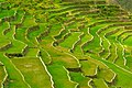
The Batad Rice Terraces' stairway to heaven

Two farmers driving a tractor towing a raft loaded with green rice sheaves to be planted in a paddy field

Planting the rice

Rice growing on dry land

Upland rice growing on a steep slope where forest had recently been cut and burned.


