JA:Tag:landuse=paddy
Jump to navigation
Jump to search
![]()
この記事は翻訳記事ですが、翻訳が不完全であり、抜けや誤り、未翻訳の部分があります。
英語版の記事の内容が分かる方は、翻訳の完成にご協力ください。このウィキの翻訳方法についての説明をお読みください。
現時点では、誰もこの記事の翻訳に取り組んでいないようですので、あなたが取り組めます。
英語版の記事の内容が分かる方は、翻訳の完成にご協力ください。このウィキの翻訳方法についての説明をお読みください。
現時点では、誰もこの記事の翻訳に取り組んでいないようですので、あなたが取り組めます。
![]()
 |
| 説明 |
|---|
| 稲作に適した地表や地形の農地。 つまり、水田。 |
| グループ: 土地利用 |
| 適用できる要素 |
| よく併用されるタグ |
| 関連項目 |
| 状態:使用中 |
| ツール |
稲作に適した地表や地形の農地。
圃場が他の作物で作付けされた場合でも、圃場の状態が変わらず、圃場が引き続き水稲に使用されるのであれば、タグは保持されるべきである。
地表の状態や灌漑などを知らずに田植えをするのであれば、crop=riceを使うだけかもしれない。 例:乾田米、陸稲など。
How to map
Draw an area![]() around the boundaries of the rice paddy, and tag with landuse=paddy.
around the boundaries of the rice paddy, and tag with landuse=paddy.
Additional tags
- name=*: If it's run by an agriculture-related agency or organization, it may have a name.
- operator=*: Indicates an agricultural operation or organization. Places run by individuals do not need to be described.
- irrigated=*: Used to indicate whether the paddy is irrigated or not. Typically, a wetted rice paddy might have irrigated=yes. An irrigated=no tag can be appended to rainfed paddy fields that are not irrigated.
- rice:race=*: Use with the 'crop=rice' tag to indicate the geographical race of the rice. There are two main families, the 'Japonica' race(rice:race=Japonica) and the 'Indica' race(rice:race=Indica). The 'Javanica' race is included in the 'Japonica' race.
See also
- surface=mud: It can be used where the condition of the land surface has been artificially made muddy.
- irrigated=*: It can be added to indicate that the land is dependent on irrigation.
- usage=irrigation: Artificial waterways which bring water to agriculture fields or facilities
Gallery

Path in the countryside with trees and paddy fields, of blond color with cut rice on the left and still green on the right

Rice farmers harvesting rice in Gambian fields.

Terraced paddy fields, Sonla, Vietnam
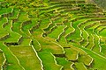
The Batad Rice Terraces' stairway to heaven

Two farmers driving a tractor towing a raft loaded with green rice sheaves to be planted in a paddy field

Planting the rice

Rice growing on dry land

Upland rice growing on a steep slope where forest had recently been cut and burned.


