File:AGESIC confirmation notice.png
Original file (2,481 × 3,508 pixels, file size: 102 KB, MIME type: image/png)
Summary
| Description | Capture of the e-mail sent by AGESIC (Uruguayan Agency for Electronic Government and Information and Knowledge Society), where the use of their data is authorized on OpenStreetMap. |
|---|---|
| Author | JAAS |
| Source | Own |
| Date | 2019-05-17 |
English
Message transcript and translation:
Good morning, Gentlemen of Agesic.
With this message I want to ask you about the Open Data License that appears in the file of the Geographical Directions of Uruguay (https://catalogodatos.gub.uy/dataset/direcciones-geograficas-del-uruguay).
According to what we interpret, this License supports us in being able to use the information and to be used in OpenStreetMap (https://www.openstreetmap.org), whenever it is included in the source and there is a reference to it " Open Data License - Uruguay". Are we understanding it correctly?
I am waiting for your comments.
Sincerely,
Jorge Aguirre
AGESIC Response
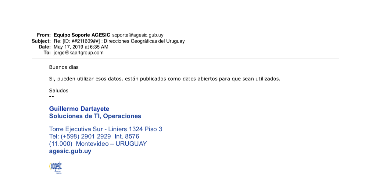
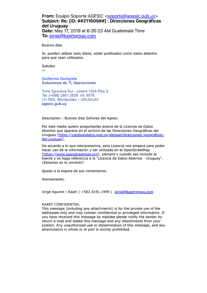
From: Equipo Soporte AGESIC <soporte@agesic.gub.uy>
Subject: Re: [ID: ##211609##] : Direcciones Geográficas del Uruguay
Date: May 17 , 2019 at 6:35:23 AM Guatemala Time
To: jorge@kaartgroup.com
Good morning
Yes, you can use this data, it is published as open data so that it can be used.
Best regards
--
Guillermo Dartayete
IT Solutions, Operations
Torre Ejecutiva Sur - Liniers 1324 Piso 3
Tel: (+598) 2901 2929 Int. 8576
(11.000) Montevideo – URUGUAY
agesic.gub.uy
Español
Captura del mensaje de correo electrónico emitido por la AGESIC (Agencia de Gobierno Electrónico y Sociedad de la Información y del Conocimiento), autorizando el uso de sus datos en OpenStreetMap.
Transcripción del mensaje:
Buenos días Señores del Agesic.
Por este medio quiero preguntarles acerca de la Licencia de Datos Abiertos que aparece en el archivo de las Direcciones Geográficas del Uruguay (https://catalogodatos.gub.uy/dataset/direcciones-geograficas-del-uruguay).
De acuerdo a lo que interpretamos, esta Licencia nos ampara para poder hacer uso de la información y ser utilizada en el OpenStreetMap (https://www.openstreetmap.org), siempre y cuando sea incluida la fuente y se haga referencia a la "Licencia de Datos Abiertos - Uruguay". ¿Estamos en lo correcto?
Quedo a la espera de sus comentarios.
Atentamente,
Jorge Aguirre
Respuesta de la AGESIC
From: Equipo Soporte AGESIC <soporte@agesic.gub.uy>
Subject: Re: [ID: ##211609##] : Direcciones Geográficas del Uruguay
Date: May 17, 2019 at 6:35:23 AM Guatemala Time
To: jorge@kaartgroup.com
Buenos dias
Si, pueden utilizar esos datos, están publicados como datos abiertos para que sean utilizados.
Saludos
--
Guillermo Dartayete
Soluciones de TI, Operaciones
Torre Ejecutiva Sur - Liniers 1324 Piso 3
Tel: (+598) 2901 2929 Int. 8576
(11.000) Montevideo – URUGUAY
agesic.gub.uy
Licensing
- This media file was uploaded by author of the work and its copyright holder.
![]()
![]()
The person who associated a work with this deed has dedicated the work to the public domain by waiving all of his or her rights to the work worldwide under copyright law, including all related and neighboring rights, to the extent allowed by law. You can copy, modify, distribute and perform the work, even for commercial purposes, all without asking permission.
File history
Click on a date/time to view the file as it appeared at that time.
| Date/Time | Thumbnail | Dimensions | User | Comment | |
|---|---|---|---|---|---|
| current | 08:52, 9 September 2024 | | 2,481 × 3,508 (102 KB) | Matheusgomesms (talk | contribs) | |
| 17:47, 17 May 2019 |  | 1,220 × 592 (89 KB) | JAAS (talk | contribs) |
You cannot overwrite this file.
File usage
There are no pages that use this file.