File:Bikepark-way.png
Jump to navigation
Jump to search

No higher resolution available.
Bikepark-way.png (256 × 256 pixels, file size: 15 KB, MIME type: image/png)
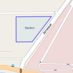
amenity=bicycle_parking way as shown on the OpenStreetMap "Mapnik" layer. As of 09 December 2010, this was the largest bike park in OSM with a capacity tag of 2000 bicycles.
http://www.openstreetmap.org/browse/way/51247499
![]()
Contains map data © OpenStreetMap contributors, made available under the terms of the Creative Commons Attribution-ShareAlike 2.0 (CC-BY-SA-2.0).
File history
Click on a date/time to view the file as it appeared at that time.
| Date/Time | Thumbnail | Dimensions | User | Comment | |
|---|---|---|---|---|---|
| current | 18:08, 9 December 2010 | | 256 × 256 (15 KB) | Rw (talk | contribs) | {{tag|amenity|bicycle_parking}} way as shown on the OpenStreetMap "Mapnik" layer. As of 09 December 2010, this was the largest bike park in OSM with a capacity tag of 2000 bicycles. |
You cannot overwrite this file.
File usage
The following 3 pages use this file: