File:Charézier (Jura). PDAC.jpg
Original file (720 × 1,280 pixels, file size: 317 KB, MIME type: image/jpeg)
Summary
DescriptionCharézier (Jura). PDAC.jpg |
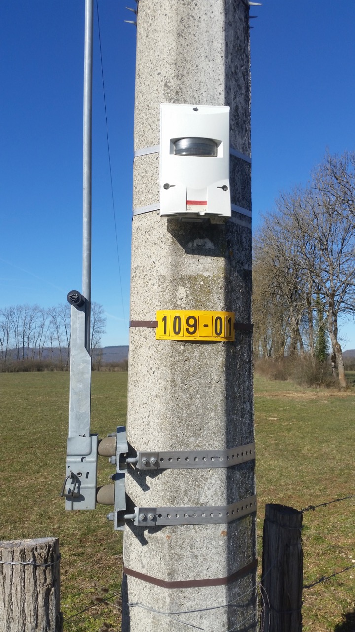
Français : Détecteur directionnel d'aide à la conduite (PDAC) installé sur un poteau d'une ligne électrique à haute-tension.
La couleur du voyant (rouge ou verte) indique la direction du court circuit (devant ou derrière le boitier). |
Date | |
Source | Own work |
Author | Pyrog |
Other versions |
|
Camera location | 46° 36′ 49.12″ N, 5° 43′ 48.37″ E | View this and other nearby images on: OpenStreetMap | 46.613644; 5.730103 |
---|
Charézier (Jura). PDAC.jpg has an entry on OpenStreetMap (show). |
العربية ∙ বাংলা ∙ Deutsch ∙ Ελληνικά ∙ English ∙ français ∙ Ido ∙ italiano ∙ македонски ∙ Nederlands ∙ português ∙ sicilianu ∙ slovenščina ∙ +/− |
Licensing
- You are free:
- to share – to copy, distribute and transmit the work
- to remix – to adapt the work
- Under the following conditions:
- attribution – You must give appropriate credit, provide a link to the license, and indicate if changes were made. You may do so in any reasonable manner, but not in any way that suggests the licensor endorses you or your use.
- share alike – If you remix, transform, or build upon the material, you must distribute your contributions under the same or compatible license as the original.
Items portrayed in this file
depicts
46°36'49.118"N, 5°43'48.371"E
27 February 2019
image/jpeg
d6f036aa0e99a9baa411b4792cf0b4318a9bc9ce
324,718 byte
1,280 pixel
720 pixel
File history
Click on a date/time to view the file as it appeared at that time.
Date/Time | Thumbnail | Dimensions | User | Comment | |
---|---|---|---|---|---|
current | 19:54, 27 February 2019 | 720 × 1,280 (317 KB) | wikimediacommons>Pyrog | User created page with UploadWizard |
File usage
The following 2 pages use this file:
Metadata
This file contains additional information, probably added from the digital camera or scanner used to create or digitize it.
If the file has been modified from its original state, some details may not fully reflect the modified file.
Camera manufacturer | samsung |
---|---|
Camera model | SM-G900F |
Exposure time | 1/1,116 sec (0.00089605734767025) |
F Number | f/2.2 |
ISO speed rating | 40 |
Date and time of data generation | 11:16, 27 February 2019 |
Lens focal length | 4.8 mm |
Latitude | 46° 36′ 49.12″ N |
Longitude | 5° 43′ 48.37″ E |
Altitude | 537 meters above sea level |
Orientation | Normal |
Horizontal resolution | 72 dpi |
Vertical resolution | 72 dpi |
Software used | Photos 4.0 |
File change date and time | 11:16, 27 February 2019 |
Exposure Program | Normal program |
Exif version | 2.2 |
Date and time of digitizing | 11:16, 27 February 2019 |
Meaning of each component |
|
APEX shutter speed | 10.12 |
APEX aperture | 2.27 |
APEX brightness | 8.89 |
APEX exposure bias | 0 |
Maximum land aperture | 2.28 APEX (f/2.2) |
Metering mode | Pattern |
Light source | Unknown |
Flash | Flash did not fire |
User comments | JKJK'�?\?�����������P?������?k�������!
������?��?���??������D?��M?������{?��v?��????????Z????8��?���M���rB??A?���?���?���?���?���?���"���?���?���?��R���Bw��Bw��Bw��Bw��Bw��R����?���?���?���?���?�������������� ���R���Bw��Bw��Bw��Bw��Bw��R����?���?���?���?���?������?���?���?���R���Bw��Bw��R���Bw��R���R����?���?���?���?���?���?��?���Q3��A"��R���Bw��Bw��Bw��?? �?? �?? ��?���?���?���?���?���?��?���Q3��A"��A"��Bw��Bw��Bw��A"��?���?���?���?���?�������?���?���?���?���R���?���?���?���?���?���?���?���@"��0���0��� ��� ���@"��A"��R���b���A"��A"��0���0���@"��@"��0���@"��@"��0��� ��� ���P3��A"��R���b���A"��A"��@"��@"��@"��@"��@"��A"��A"��@"��0���0���@"��A"��R���b���A"��A"��@"��A"��@"��@"��A"��@"��A"��A"��@"��A"��@"��A"��Q3��Q3��A"��A"��@"��A"��@"��A"��A"���?���?���?���?���?���?���?���?���"��A"��A"��0���0���A"��A"��A"���?���?���?���?���?���?���?���?���?��A"��Bw��0���A"��Bw��Bw��Bw���?���?���?���?���?���?���?���?������������������ ���Bw��Bw��Bw���?���?���?���?���?���?���?���?���?��A"��Bw��Bw��Bw��R���A"��A"���?���?���?���?���?���?���?���?���?��A"��Bw��Bw��Bw��A"��P3��A"���?���?���?���?���?���?���?���?���?��A"��Bw��Bw��Bw��R���P3��Q3���?��??��?|��??������??��??������>?��������������������������������������??��??��d?��?W������U?��l?��??��HM��������������??������u?��??������o?��??������o?��??������o?��??������o?���������������?��??�� �������?3��������������FAFA��?�?��0��?�?���FAFAe�������G'??�?n�?;�f?,�&�?t� ��z?)?X�?y�%5�??)?l�(?�?��??'?��??�??�??,k?�?������������?�??�??,k?�??�??�??,k?�??�??�??,k?�?������������?�??�??,k?�??�??�??,k?�??�??�??,k?�??�??�??,k?�??�??�??,k?�??�??�??,k?�??�??�??,k?�??�??�??,k?�??�??�??,k?�?FAFA��g Z y���?�����f���?�?�?���T�����?���F�l�?���(���������! ��������������������3�����������������ZP����������?�����������������������?���?�?�FAFA��������������������������������������????F���! ������g ��u������� �?�����? ��e ��&������������������������������������������������������������������������I��?=����������������������u ��������������������������������������������������������������8�������r���������������?���????������������(���\���������������?���! ������?�����������������������������������t���s���????��������|���������������.���5���? ��h ��2 ��5���b�����������U�������P02011165F16QLGB00VB51FFEFDDFA4 |
DateTime subseconds | 53 |
DateTimeOriginal subseconds | 53 |
DateTimeDigitized subseconds | 53 |
Supported Flashpix version | 1 |
Color space | sRGB |
Sensing method | One-chip color area sensor |
Scene type | A directly photographed image |
Exposure mode | Auto exposure |
White balance | Auto white balance |
Focal length in 35 mm film | 31 mm |
Scene capture type | Standard |
GPS time (atomic clock) | 10:16 |
GPS date | 27 February 2019 |
GPS tag version | 2.2.0.0 |
IIM version | 2 |
Keywords | PDAC (Pigeon/détecteur directionnel d'aide à la conduite) |
Short title | 109-01 |