File:Landuse=grass-example.png
Jump to navigation
Jump to search

No higher resolution available.
Landuse=grass-example.png (279 × 234 pixels, file size: 28 KB, MIME type: image/png)
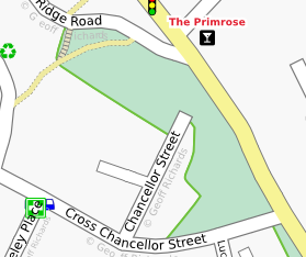
An example of Osmarender rendering green areas of land tagged with landuse=grass.
This shows part of Meanwood Road in Leeds. Splippy map link: http://www.openstreetmap.org/?lat=53.82387&lon=-1.5597&zoom=16&layers=0BFT
![]()
Contains map data © OpenStreetMap contributors, made available under the terms of the Creative Commons Attribution-ShareAlike 2.0 (CC-BY-SA-2.0).
File history
Click on a date/time to view the file as it appeared at that time.
| Date/Time | Thumbnail | Dimensions | User | Comment | |
|---|---|---|---|---|---|
| current | 21:26, 21 January 2008 | | 279 × 234 (28 KB) | Geoff (talk | contribs) | An example of Osmarender rendering a green area of land tagged with landuse=grass. This shows part of Meanwood Road in Leeds. Splippy map link: http://www.openstreetmap.org/?lat=53.81474&lon=-1.54586&zoom=17&layers=0BFT |
| 18:56, 21 January 2008 | 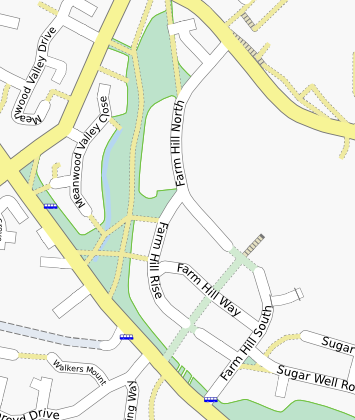 | 355 × 420 (87 KB) | Geoff (talk | contribs) | An example of Osmarender rendering green areas of land tagged with landuse=grass. This shows part of Meanwood Road in Leeds. Splippy map link: http://www.openstreetmap.org/?lat=53.82387&lon=-1.5597&zoom=16&layers=0BFT |
You cannot overwrite this file.
File usage
The following page uses this file: