File:ODOT TIMS Copyright.png
Original file (2,215 × 555 pixels, file size: 44 KB, MIME type: image/png)
Summary
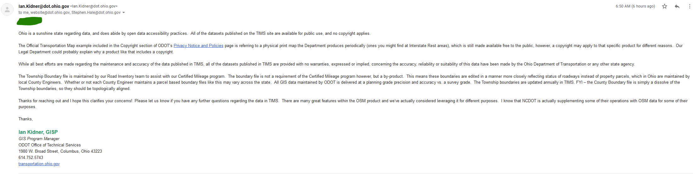
| Description | Email from Ian Kidner, GISP, ODOT Office of Technical Services
Transcript: The Township Boundary file is maintained by our Road Inventory team to assist with our Certified Mileage program. The boundary file is not a requirement of the Certified Mileage program however, but a by-product. This means these boundaries are edited in a manner more closely reflecting status of roadways instead of property parcels, which in Ohio are maintained by local County Engineers. Whether or not each County Engineer maintains a parcel based boundary files like this may vary across the state. All GIS data maintained by ODOT is delivered at a planning grade precision and accuracy vs. a survey grade. The Township boundaries are updated annually in TIMS. FYI - the County Boundary file is simply a dissolve of the Township boundaries, so they should be topologically aligned. Thanks for reaching out and I hope this clarifies your concerns! Please let us know if you have any further questions regarding the data in TIMS. There are many great features within the OSM product and we've actually considered leveraging it for different purposes. I know that NCDOT is actually supplementing some of their operations with OSM data for some of their purposes Thanks, |
|---|---|
| Author | User:Korgi1 |
| Source | https://imgur.com/YMy4EUI |
| Date | July 22, 2021 |
Licensing

If you are the uploader, please provide proper attribution including source and name of author.
File history
Click on a date/time to view the file as it appeared at that time.
| Date/Time | Thumbnail | Dimensions | User | Comment | |
|---|---|---|---|---|---|
| current | 23:42, 23 July 2024 | 2,215 × 555 (44 KB) | MattMap (talk | contribs) | {{Information | description= Email from Ian Kidner, GISP, ODOT Office of Technical Services<br/> '''Transcript''':<br />Ohio is a sunshine state regarding data, and does abide by open data accessibility practices. All of the datasets published on the TIMS site are available for public use, and no copyright applies.<br /> The Official Transportation Map example included in the Copyright section of ODOT's Privacy Notice and Policies page is referring to a physical print map the Department produ... |
You cannot overwrite this file.
File usage
The following page uses this file: