File:Plantuml-Simple school-old.png
Jump to navigation
Jump to search

No higher resolution available.
Plantuml-Simple_school-old.png (483 × 325 pixels, file size: 19 KB, MIME type: image/png)
Source code
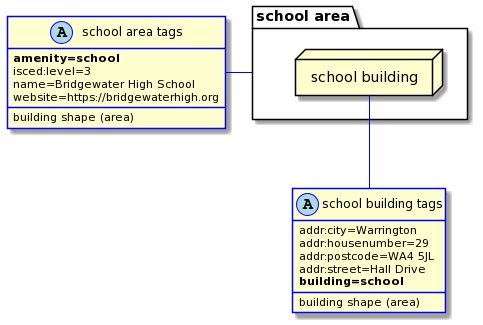
Generated with PlantUML from following code:
' Diagram for school tagging
' 2022 Author: https://osm.org/user/kubahahaha
' This code is published under WTFPL Public Licence version 2

@startuml
allow_mixing

skinparam class {
  BorderColor<<Area>> Blue
  BorderColor<<Node>> Red
}
hide stereotype

package "school area" AS sArea {
  node "school building" AS sSchool
}

class "school building tags" <<(A,lightblue) Area>> {
  addr:city=Warrington
  addr:housenumber=29
  addr:postcode=WA4 5JL
  addr:street=Hall Drive
  **building=school**
  building shape (area)
}

class "school area tags" <<(A,lightblue) Area>> {
  **amenity=school**
  isced:level=3
  name=Bridgewater High School
  website=https://bridgewaterhigh.org
  building shape (area)
}

"school area tags" - sArea #blue
sSchool -- "school building tags" #blue
@enduml
Licensing
Source code and produced image is licenced under WTFPL Public Licence version 2 (full text).
- This media file was uploaded by author of the work and its copyright holder.
![]()
Permission is granted to do what the fuck you want to with this document under the terms of the WTF Public License, Version 2.
File history
Click on a date/time to view the file as it appeared at that time.
| Date/Time | Thumbnail | Dimensions | User | Comment | |
|---|---|---|---|---|---|
| current | 19:19, 3 February 2022 | | 483 × 325 (19 KB) | Kubahaha (talk | contribs) |
You cannot overwrite this file.
File usage
The following page uses this file:
- File:Plantuml-Simple school.png (file redirect)