File:Ru Minlevel2.svg
Jump to navigation
Jump to search


Size of this PNG preview of this SVG file: 789 × 600 pixels. Other resolutions: 316 × 240 pixels | 631 × 480 pixels | 1,010 × 768 pixels | 1,280 × 973 pixels | 1,135 × 863 pixels.
Original file (SVG file, nominally 1,135 × 863 pixels, file size: 13 KB)
Summary
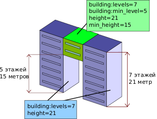
| Description | schematic example of level and height tagging |
|---|---|
| Author | Aschilli, Grass-snake |
| Source | File:Minlevel2.svg, translated by Grass-snake |
| Date | 2024-06-20 |
| Other versions | File:Minlevel2.svg (English version) File:Ru Minlevel.svg (another image) |
Licensing
![]()
This file has been released into the public domain by the copyright holder, its copyright has expired, or it is ineligible for copyright. This applies worldwide.
Please, please use more specific template such as {{PD-self}} / {{PD-creator}} / {{PD-shape}} / {{PD-USGov}} / {{PD-old}} / {{PD-RU-exempt}} ... This template is not making clear why this work is in the public domain.
Please, please use more specific template such as {{PD-self}} / {{PD-creator}} / {{PD-shape}} / {{PD-USGov}} / {{PD-old}} / {{PD-RU-exempt}} ... This template is not making clear why this work is in the public domain.
File history
Click on a date/time to view the file as it appeared at that time.
| Date/Time | Thumbnail | Dimensions | User | Comment | |
|---|---|---|---|---|---|
| current | 20:48, 20 June 2024 | | 1,135 × 863 (13 KB) | Grass-snake (talk | contribs) | {{Information | description=schematic example of level and height tagging | source=File:Minlevel2.svg, translated by Grass-snake | date=2024-06-20 | author=Aschilli, Grass-snake | other_versions=File:Minlevel2.svg (English version)<br>File:Ru Minlevel.svg (another image)}} |
You cannot overwrite this file.
File usage
The following 2 pages use this file: