File:YAI-Frankfurt.png
Jump to navigation
Jump to search


Size of this preview: 639 × 600 pixels. Other resolutions: 256 × 240 pixels | 512 × 480 pixels | 988 × 927 pixels.
Original file (988 × 927 pixels, file size: 1,016 KB, MIME type: image/png)
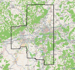
Area around Frankfurt/M with high resolution coverage in Yahoo! Aerial Imagery. Composed with OSM Mapnik source material
![]()
Contains map data © OpenStreetMap contributors, made available under the terms of the Creative Commons Attribution-ShareAlike 2.0 (CC-BY-SA-2.0).
File history
Click on a date/time to view the file as it appeared at that time.
| Date/Time | Thumbnail | Dimensions | User | Comment | |
|---|---|---|---|---|---|
| current | 18:23, 22 March 2009 | | 988 × 927 (1,016 KB) | Dirkolus (talk | contribs) | Area around Frankfurt/M with high resolution coverage in Yahoo! Aerial Imagery. Composed with OSM Mapnik source material |
You cannot overwrite this file.
File usage
There are no pages that use this file.