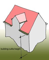
Key:building:cullis:height
Jump to navigation
Jump to search
 |
| Description |
|---|
| Maximal measurable height between terrain and the lower edge of the cullis. |
| Group: 3D |
| Used on these elements |
| Requires |
|
|
| Status: proposed |
| Tools for this tag |
|
building:cullis:height=* = is the maximal measurable height between terrain and the lower edge of the cullis.
Cullis - a gutter in a roof.
