| Graphic
|
Status
|
Description
|
Tagging & Rendering
|

|
In use
|
A park, which:
- is 100% manicured parkland
- is not a protected area
|
- A polygon representing the area of the park is tagged with
leisure=park
- The park area renders as a fill.
|

|
Proposed
|
A park, which:
- is 100% manicured parkland
- is not a protected area
- is not properly categorized under IUCN category definitions for conservation land
|
|

|
Proposed
|
A park, which:
- has no manicured parkland
- is a protected area
- is not properly categorized under IUCN category definitions for conservation land
|
|

|
Proposed
|
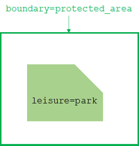
A park, which:
- has some areas of manicured parkland
- is a protected area
- does not meet IUCN category definitions for conservation land
|
- A polygon representing the area of the park is tagged with
boundary=protected_area.
- Internal regions of manicured parkland are tagged with
leisure=park.
- The area renders as a visible border with no fill.
- The internal manicured parkland areas render with a fill.
|

|
In use
|
A park, which:
- has no manicured parkland
- is a protected area
- meets IUCN category definitions for conservation land
|
|

|
In use
|
- has some areas of manicured parkland
- is a protected area
- meets IUCN category definitions for conservation land
|
- A polygon representing the area of the park is tagged with
boundary=protected_area and protect_class=*.
- Internal regions of manicured parkland are tagged with
leisure=park.
- The area renders as a visible, emphasized border with no fill.
- The internal manicured parkland areas render with a fill.
|


