Uploads by Apm-wa
Jump to navigation
Jump to search
This special page shows all uploaded files.
| Date | Name | Thumbnail | Size | Description | Versions |
|---|---|---|---|---|---|
| 02:14, 3 October 2023 | 20230921 two new villages Ahal welayat.pdf (file) | 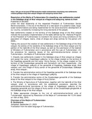 |
138 KB | {{Information | description= Turkmen and English language decree naming two new villages in Gokdepe etraby | source= https://tdh.gov.tm/en/post/37766/resolution-mejlis-turkmenistan-classifying-new-settlements-created-gokdepe-etrap-ahal-velayat-villages-and-assigning-names-them | date= 21 September 2023 | author= Government of Turkmenistan | other_versions= }} | 1 |
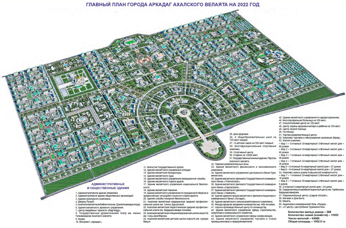
| 20:07, 23 December 2022 | Arkadag-city-layout.jpg (file) |  |
410 KB | {{Information | description=appendix to Turkmen parliamentary decree showing layout of Arkadag city | source=official Turkmen state media | date=21 December 2022 | author= | other_versions= }} | 1 |
| 19:28, 23 December 2022 | 20221220 Arkadag city named RU TK.pdf (file) |  |
149 KB | {{Information | description=text of parliamentary decree of 20 December 2022 | source=Turkmen official state media | date=20 December 2022 | author= | other_versions= }} | 1 |
| 23:43, 15 November 2022 | 20221109 Turkmenistan parliamentary decree.pdf (file) |  |
263 KB | {{Information | description=copy of Turkmen parliamentary decree of 9 Nov 2022 on geographic changes | source= turkmenistan.gov.tm | date= 9 November 2022 | author= government of Turkmenistan | permission= public domain under Turkmen copyright law (acts of parliament cannot be copyrighted under Turkmen law) | other_versions= }} | 1 |
| 00:44, 17 May 2020 | J-40-081-Ashgabat-excerpt.jpg (file) |  |
11.63 MB | excerpt from Soviet General Staff (military) map J-40-081 of 1974, showing boundaries of Ashgabat and populated areas around Ashgabat at that time. | 1 |
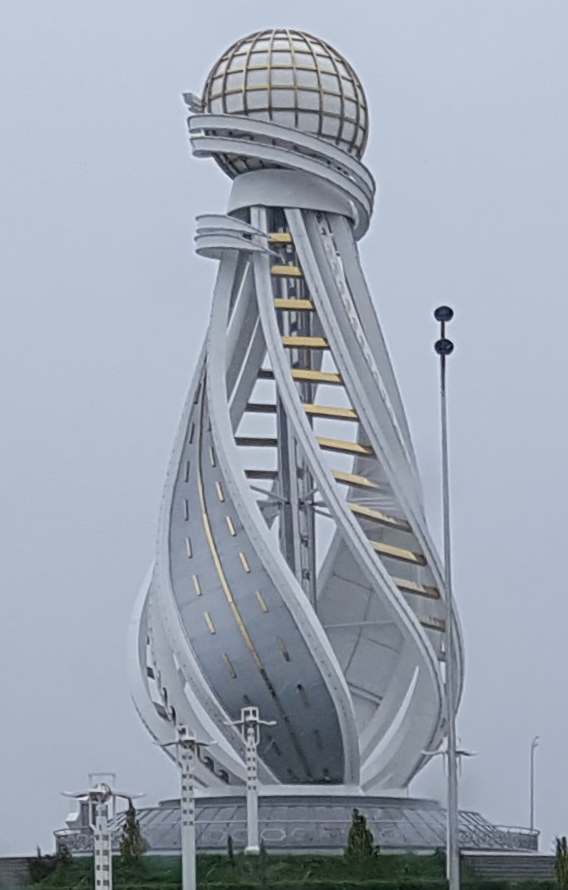
| 00:44, 18 January 2020 | Silkroadmonument.jpg (file) |  |
237 KB | Photo of Silk Road Monument in Turkmenabat, Turkmenistan, taken by apm-wa via Mapillary. (CC BY-SA 4.0) Mapillary. | 1 |
| 00:31, 18 January 2020 | Turkmenabat city boundaries 2016.jpg (file) |  |
173 KB | Map depicting new boundaries of city of Turkmenabat, Lebap, Turkmenistan, as of July 2016, based on parliamentary resolution 425-V passed 7 July 2016. | 1 |
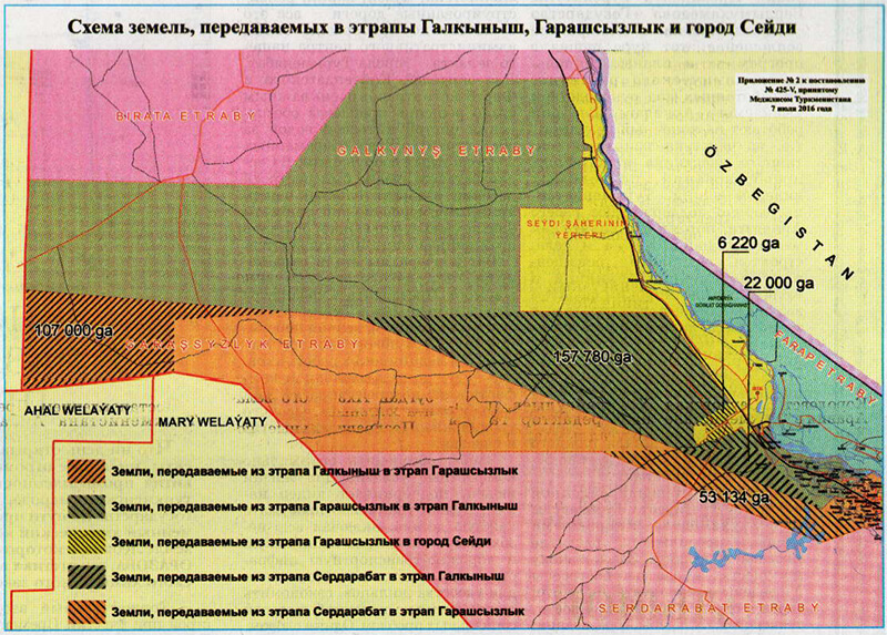
| 00:28, 18 January 2020 | Lebap 2016 district changes.jpg (file) |  |
343 KB | District boundary changes in Lebap province of Turkmenistan, affecting Galkynysh and Garashsyzlyk districts plus city of Seydi, based on Resolution 425-V of 7 July 2016. | 1 |
| 00:23, 18 January 2020 | Lebap district changes.jpg (file) |  |
244 KB | Map showing results of Turkmen Parliamentary Resolution No. 425-V of 27 July 2016, changing boundaries of districts in Lebap province. Published in the official gazette of the government of Turkmenistan. | 1 |
| 15:59, 13 January 2020 | Maperitive.gif (file) |  |
38 KB | Logo for Maperitive by Igor Brejc. Copyright © 2010-2012 Igor Brejc | 1 |
| 16:20, 26 December 2019 | 2002 Name change from Tagta to Gorogly.pdf (file) |  |
265 KB | Copy of 25 September 2002 presidential decree PP-3724 renaming Tagta etrap (district) to Görogly etrap. | 1 |
| 17:18, 30 May 2019 | 2004-06-04-TKM-Pres-Decree-4066-ocr.pdf (file) | 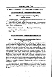 |
69 KB | Turkmenistan Presidential Decree No. 4066 of 4 June 2004 changing the name of Garrygala (aka Garry Gala, Kara Kala, Karakalinsk) to Magtymguly. This change affected both the city and the district bearing those names. | 1 |
| 17:06, 30 May 2019 | 2000-11-10-TKM-Pres-Decree-3204.pdf (file) | 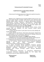 |
112 KB | Turkmenistan Presidential Decree No. 3204 of 10 November 2000, incorporating the villages of Pöwrize (Firuza) and Wanowskiý into a new city of Arçabil (Archabil), which itself was subsequently abolished and its territory annexed by the city of Ashga... | 1 |
| 16:17, 9 May 2019 | 19930914 Proletar and Sowet name change Turkmen.pdf (file) | 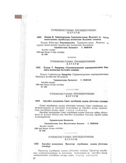 |
918 KB | Turkmenistan decree ordering changes of the names of Proletar and Sowet boroughs of Ashgabat city, dated 14 September 1993, in the Turkmen language. | 1 |
| 16:08, 9 May 2019 | 19921214 XM-6.pdf (file) | 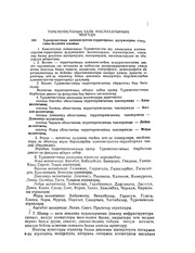 |
85 KB | Series of geographic name changes ordered by the Halk Maslahaty (People's Council) of Turkmenistan on 14 December 1992 in Parliamentary Resolution XM-6, in the Turkmen language, using the Turkmen Cyrillic alphabet. | 1 |
| 17:41, 7 May 2019 | 19930914 1490-1491 Sowet and Proletar name change.pdf (file) | 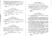 |
70 KB | Russian text of Turkmenistan Presidential Decrees 1490 and 1491, renamed Sowet etraby and Proletar etraby (Советский этрап, Пролетарский этрап) of Ashgabat city, dated 14 September 1993. | 1 |
| 17:31, 7 May 2019 | 19930216 1177 1178 1179 Kalinin Telman and Lenin name change 1993.pdf (file) | 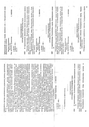 |
68 KB | Turkmenistan Presidential Decrees 1177, 1178, and 1179 of 16 February 1993 changing the names of Kalinin, Telman, and Lenin districts (etraplar) of Dashhowuz welayaty. | 1 |
| 16:46, 7 May 2019 | 19930505 Decree1327 RU ocr.pdf (file) | 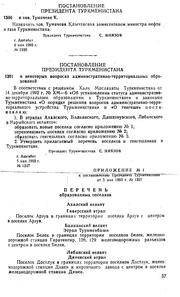 |
1.55 MB | Russian text of Presidential Decree No. 1327 of 5 May 1993 changing the geographic names of several municipalities in Turkmenistan. | 1 |
| 04:51, 5 May 2019 | 1992-2018-TKM geoname changes TK-ocr.pdf (file) | 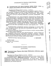 |
11.97 MB | Collection of Turkmenistan government decrees and parliamentary resolutions regarding geographic names, from 1992 to 2018. This collection is not all-inclusive. Documents are in either the Russian or Turkmen languages. | 1 |
| 13:57, 3 May 2019 | 190409 ASB 7000.svg (file) |  |
6.04 MB | Scalable vector graphic (SVG) map of central Ashgabat city generated with Maperitive and edited with Inkscape. This file presses the outer limits of Inkscape's memory management. This is not the final product, as the final map had to be edited in Core... | 1 |
| 16:11, 23 January 2019 | 190123 TKM-smaller.jpg (file) |  |
21.76 MB | Map of Turkmenistan as of 21 January 2019 depicting trunk, primary, secondary, and tertiary highways; cities, towns, and selected villages; gas stations; and railways. Generated using Osmosis, Maperitive, and Corel Photo Paint by Allan Mustard. | 1 |
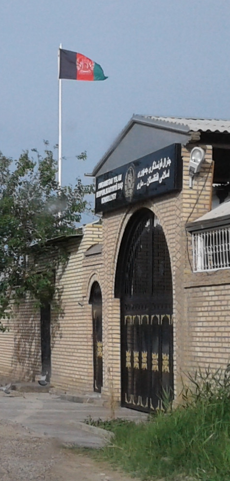
| 17:32, 21 October 2018 | AFG-congen.jpg (file) |  |
347 KB | Afghanistan consulate general in Mary, Turkmenistan, with sign in Turkmen and one of the Afghan languages. Photo by Allan Mustard via Mapillary. | 1 |
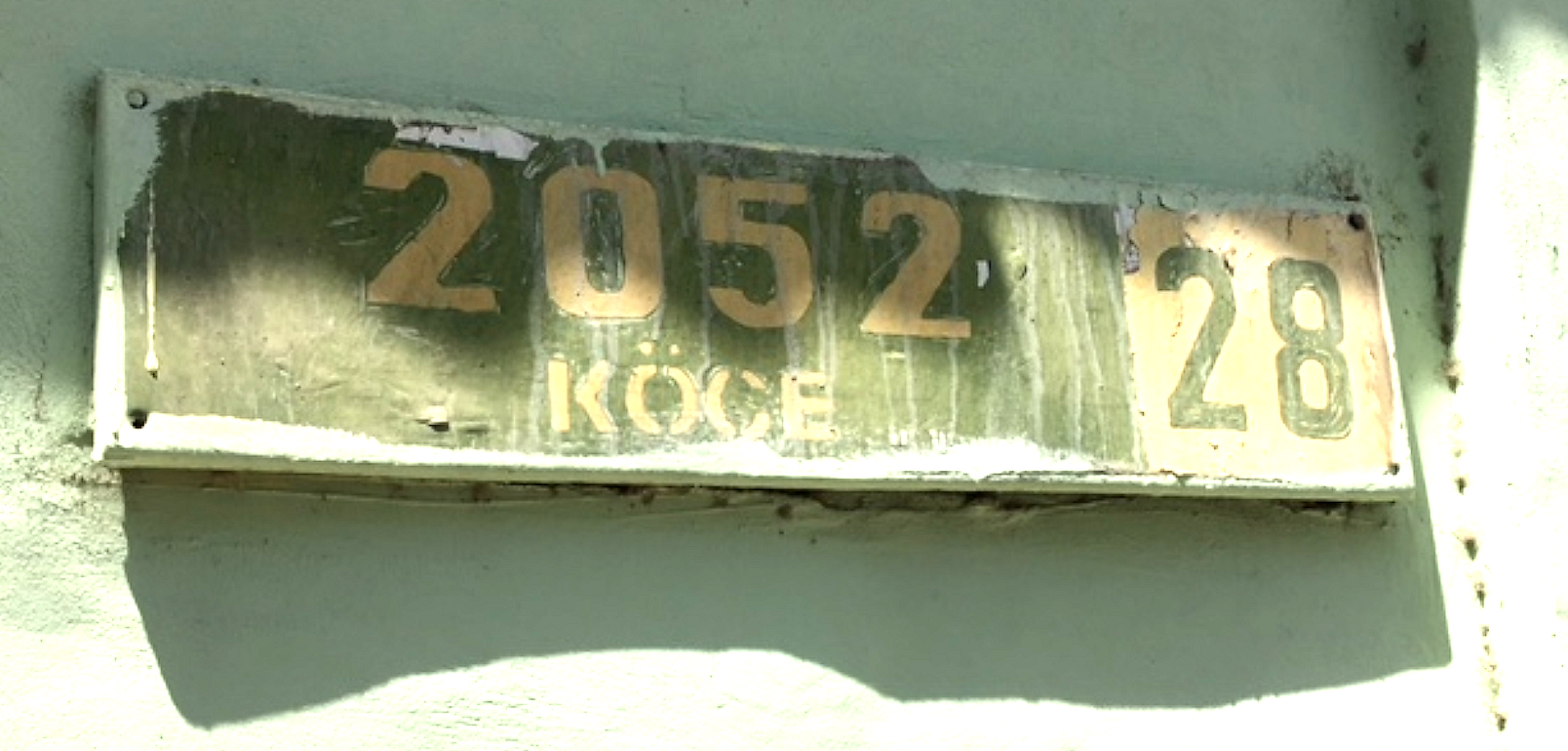
| 15:22, 10 August 2018 | 2052-cropped.jpg (file) |  |
1,023 KB | Legacy street sign identifying 2052 köçe (2052 Street) in Ashgabat, Turkmenistan, currently named Hydyr Derýaýew köçesi. Photo by Allan Mustard. | 1 |
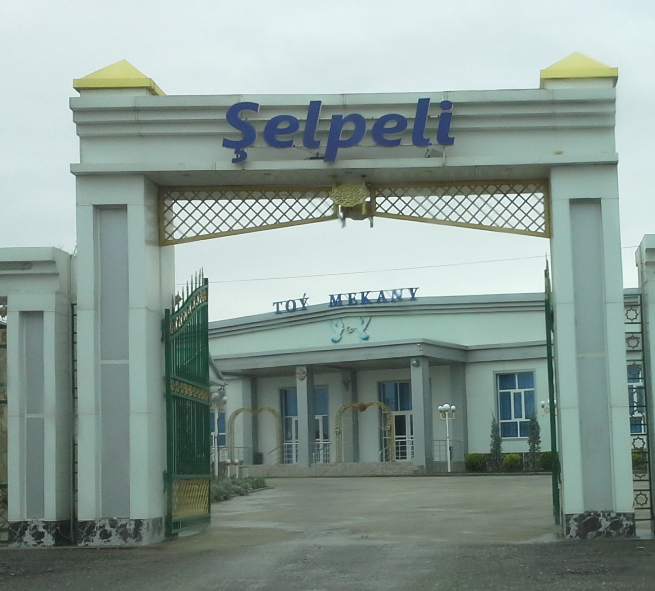
| 14:47, 10 August 2018 | Selpeli-toy-mekany.jpg (file) |  |
1.4 MB | Entrance to the Şelpeli Toý Mekany, an events venue in Bagyr neighborhood of Ashgabat, Turkmenistan. Such venues are used to host wedding receptions, baby showers, and other similar events. Photo by Allan Mustard via Mapillary. | 1 |
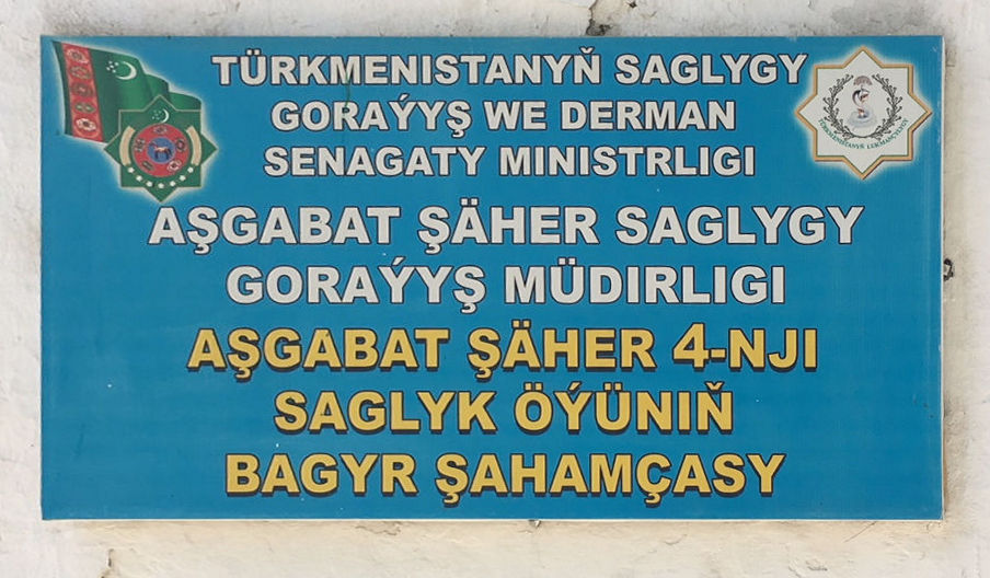
| 16:15, 8 August 2018 | Bagyr-clinic-sign.jpg (file) |  |
147 KB | Typical sign for a health (medical) clinic in Turkmenistan. The Turkmen text reads, "Turkmenistan Ministry of Health Service and Pharmaceutical Industry" "Ashgabat City Health Service Directorate" "Ashgabat City 4th Health House Bagyr Branch" (i.e., t... | 1 |
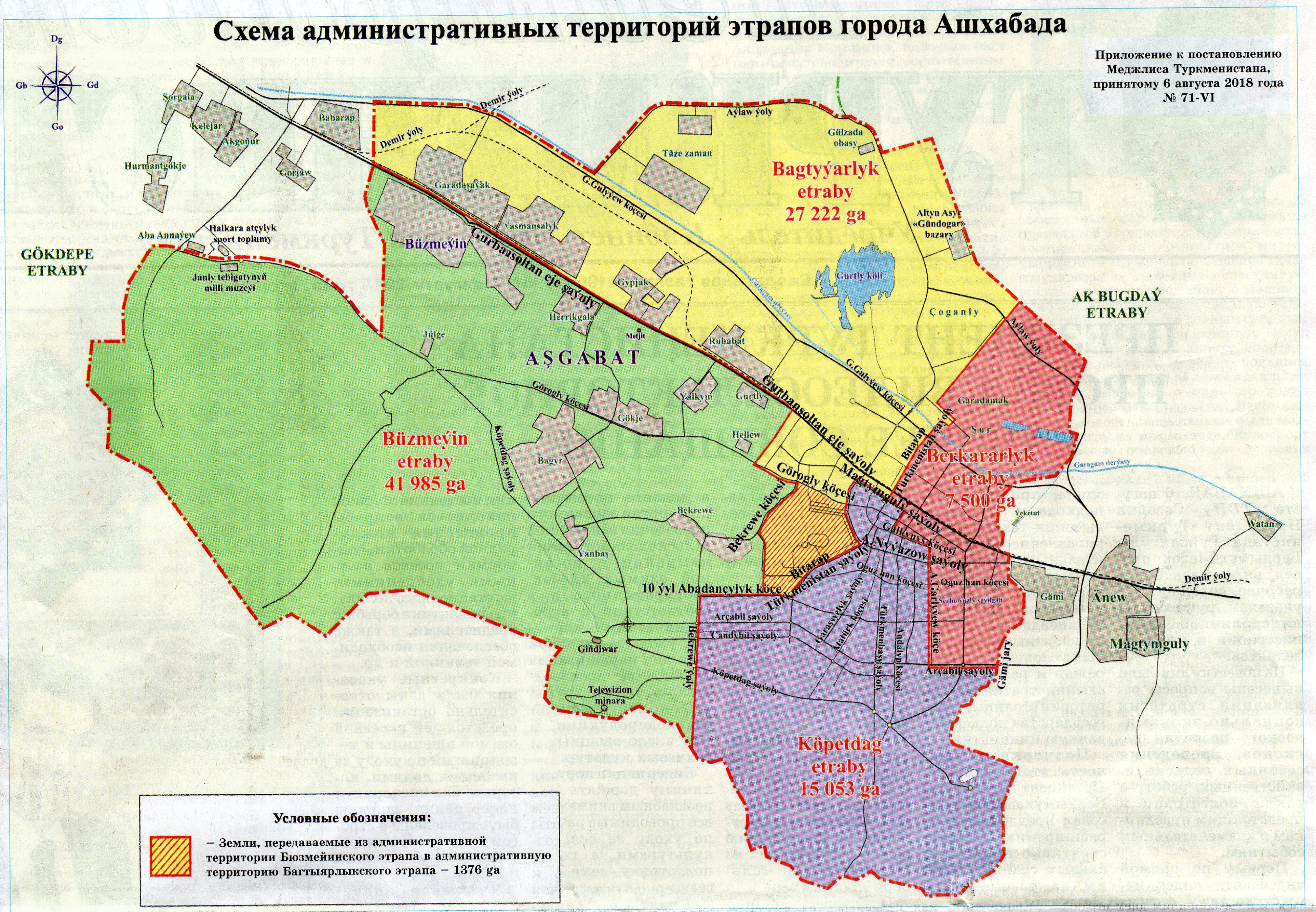
| 12:42, 7 August 2018 | 180806 Ashgabat etrap boundaries.jpg (file) |  |
3.36 MB | Official boundaries of the city of Ashgabat and its four boroughs as of 6 August 2018, as published in the official daily newspaper "Neytral'nyy Turkmenistan" on page 2 | 1 |
| 18:15, 12 July 2018 | 40kph-sign.JPG (file) |  |
66 KB | A 40 kilometer per hour sign in a school zone in Ashgabat, Turkmenistan. Photo by Allan Mustard. | 1 |
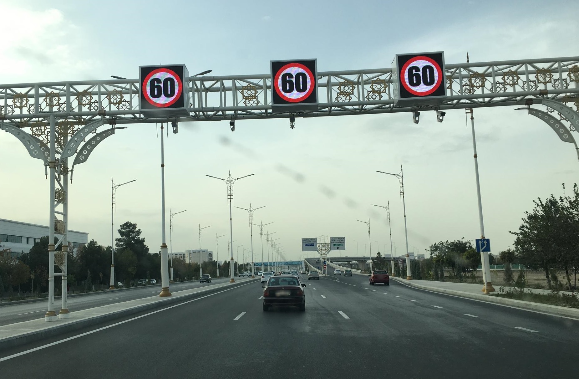
| 08:49, 11 July 2018 | Ashgabat-speed-limit-gantry.jpg (file) |  |
487 KB | Speed limit gantry with signage plus radar cameras on Gurban Soltan Eje in Ashgabat, Turkmenistan. Photo by Allan Mustard | 1 |
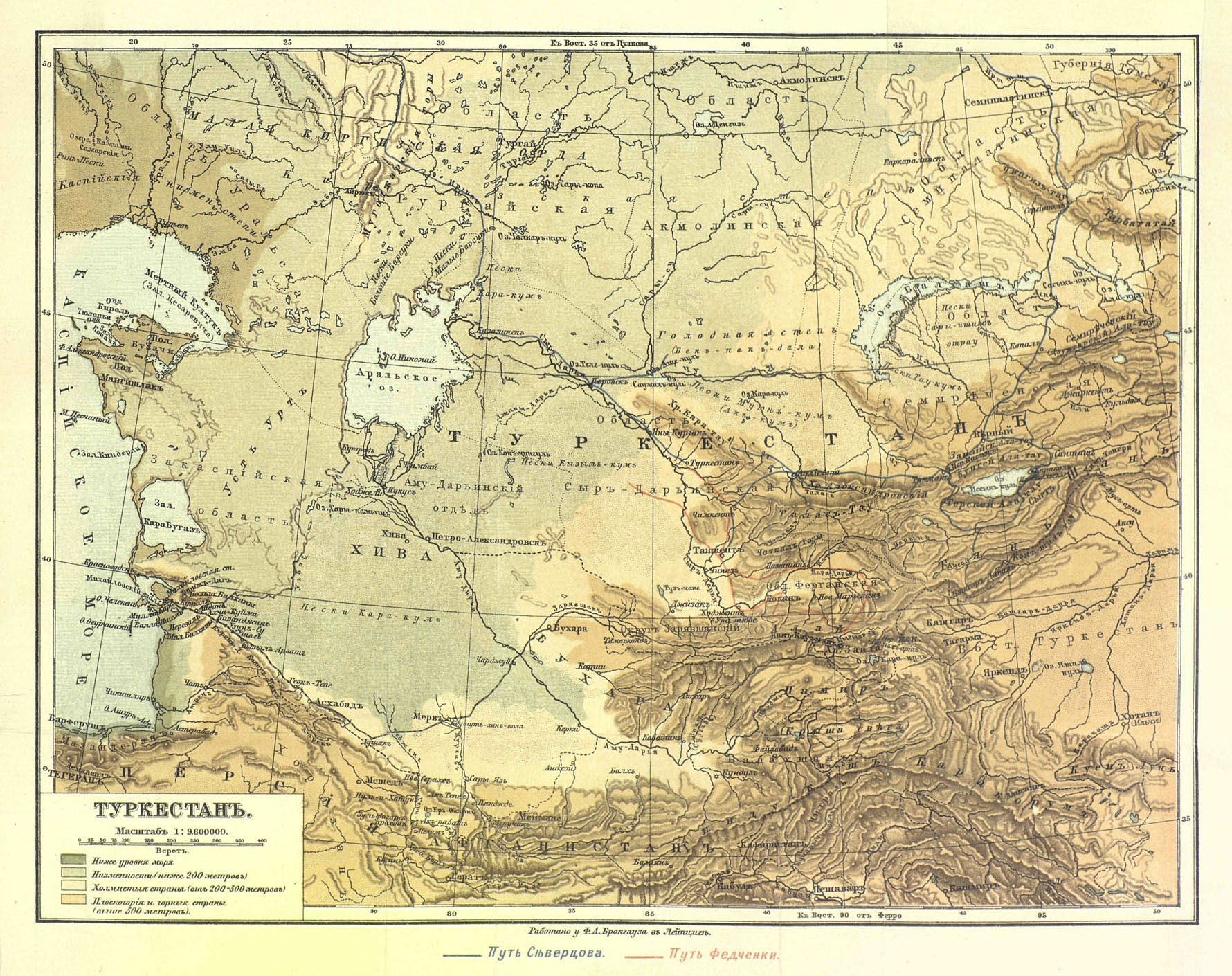
| 16:13, 9 July 2018 | Turkestan-map.jpg (file) |  |
749 KB | A 19th-century map of "Turkestan". Copyright has expired. | 1 |
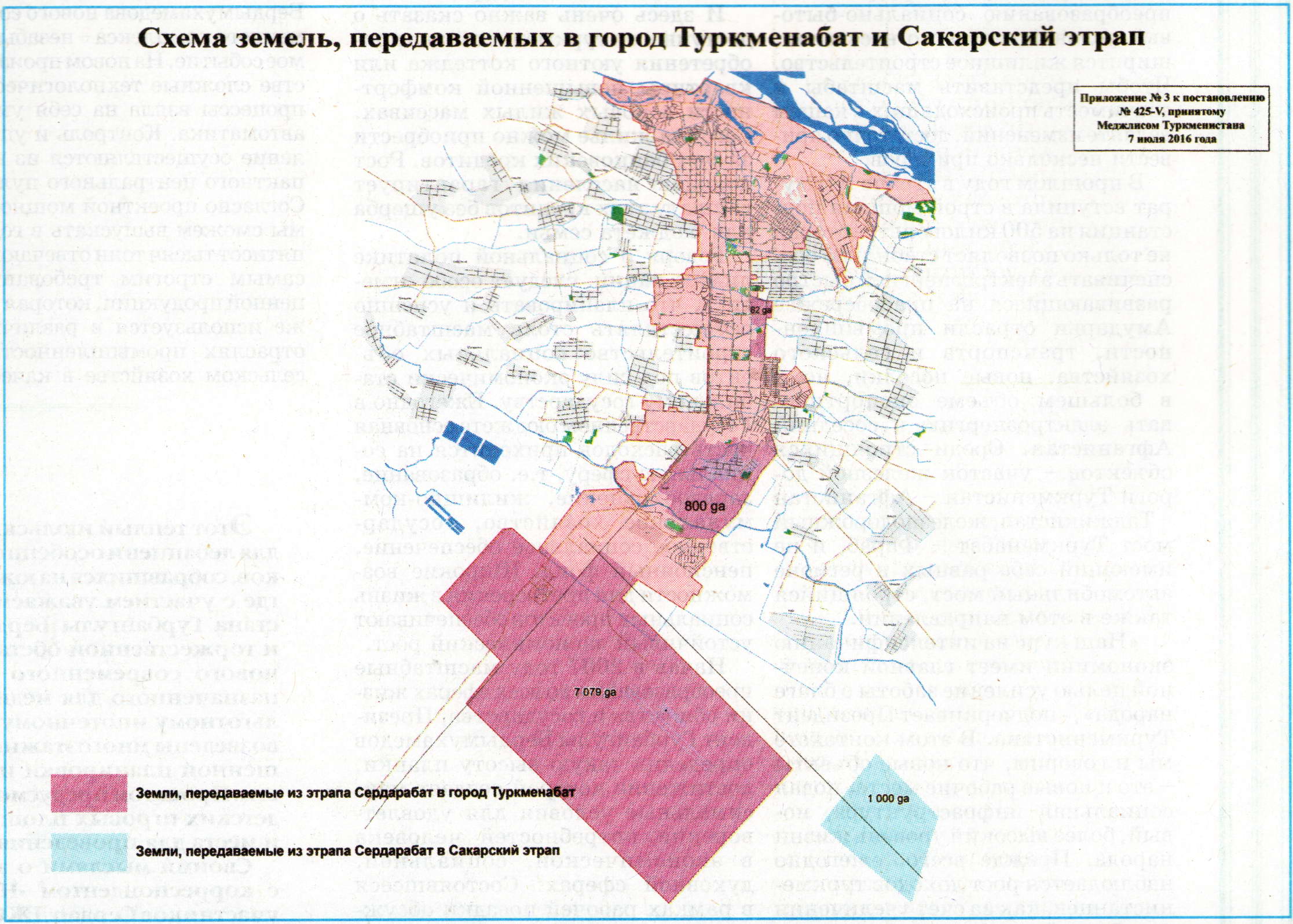
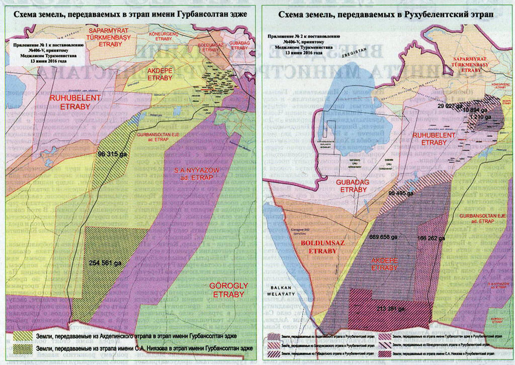
| 15:13, 9 July 2018 | Turkmenabat-new-lands.jpg (file) |  |
404 KB | Map published in the official gazette of Turkmenistan in July 2016 depicting new territories added to the city of Turkmenabat. The large rectangle at the southern end of the city is the location of the new international airport inaugurated in February... | 1 |
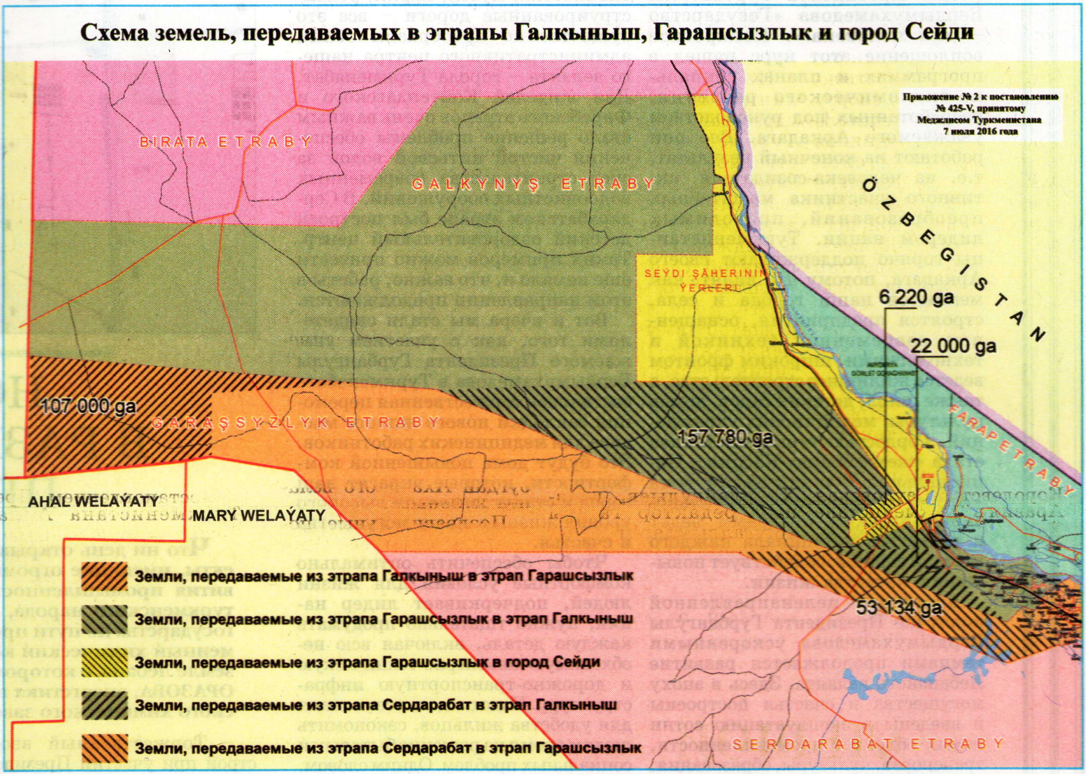
| 15:08, 9 July 2018 | Lebap-Galkynysh-Garashsyzlyk-Seydi-land-swaps.jpg (file) |  |
629 KB | Map published July 2016 in the official gazette of Turkmenistan, depicting land swaps among Galkynyş and Garaşsyzlyk Districts (''etraplary'') and the city of Seýdi, Lebap Province, Turkmenistan. | 1 |
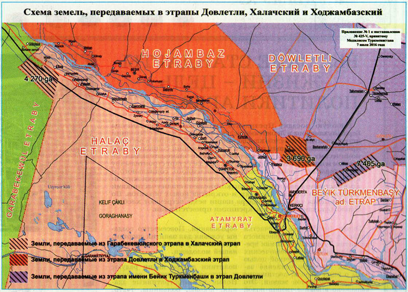
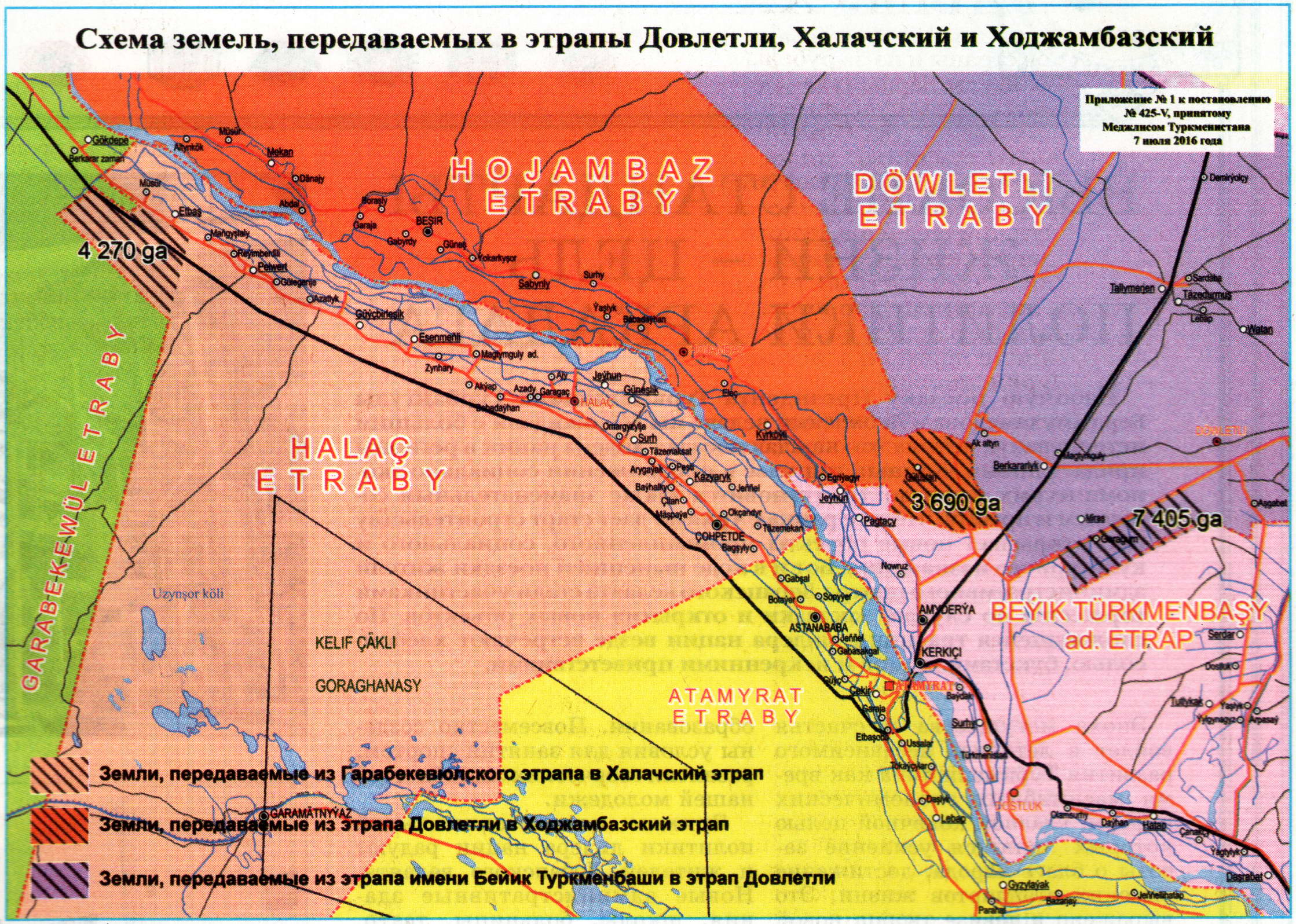
| 15:03, 9 July 2018 | Lebap-Dovletli-Halach-Hojambaz-land-swaps.jpg (file) |  |
886 KB | Map from July 2016 depicting land swaps among Döwletli, Halaç, and Hojambaz Districts (etraplary) of Lebap Province, Turkmenistan, published as an official notice of the Turkmenistan government. | 1 |
| 12:35, 8 July 2018 | Pygg.jpg (file) |  |
270 KB | Turkmenistan traffic police stationary checkpoint building, on Gurban Soltan Eje near Ashgabat. Photo by Allan Mustard. | 1 |
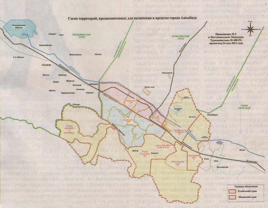
| 11:58, 8 July 2018 | 2013May27 new map of Ashgabat and Akhal 2.jpg (file) |  |
114 KB | Historical map of Ashgabat and surrounding area of Ahal Province as of 27 May 2013, when parts of Ahal Province were annexed by the city. | 1 |
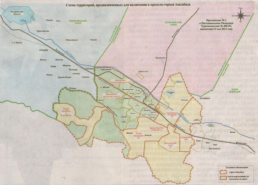
| 11:51, 8 July 2018 | 2013May27 new map of Ashgabat and Akhal 1.jpg (file) |  |
108 KB | Boundaries of the city of Ashgabat, Turkmenistan, as of May 27, 2013, following annexation of Ruhabat District and city of Abadan of Ahal Province. | 1 |
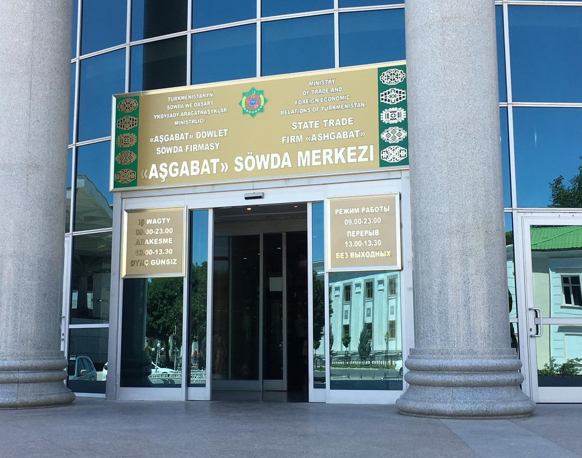
| 10:09, 8 July 2018 | Ashgabat-sowda-merkezi.jpg (file) |  |
798 KB | Entrance to the Aşgabat Söwda Merkezi (Ashgabat Shopping Center) in Ashgabat, Turkmenistan. Photo by Allan Mustard. | 1 |
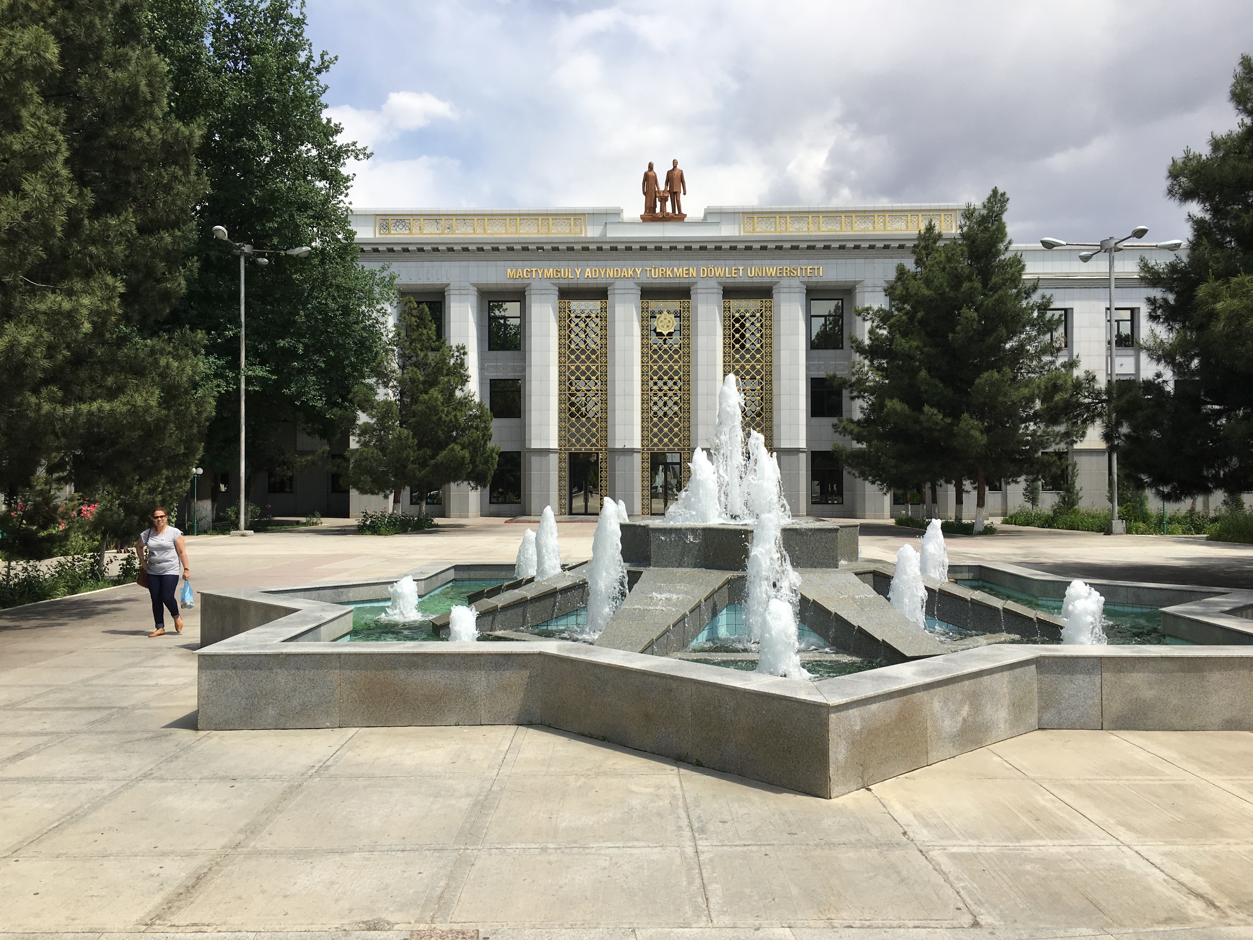
| 16:46, 7 July 2018 | Turkmen-state-university.jpg (file) |  |
3.1 MB | Main building of Magtymguly Turkmen State University in Ashgabat, Turkmenistan. Photograph taken by Allan Mustard. | 1 |
| 13:32, 7 July 2018 | Kindergarten-Ashgabat-Turkmenistan.jpg (file) |  |
773 KB | Typical kindergarten in Ashgabat, Turkmenistan, labeled as such in the Turkmen language | 1 |
| 11:24, 7 July 2018 | Dashoguz-etrap-map.jpg (file) |  |
226 KB | Map of districts of Dashoguz Province of Turkmenistan as of 2017. | 1 |
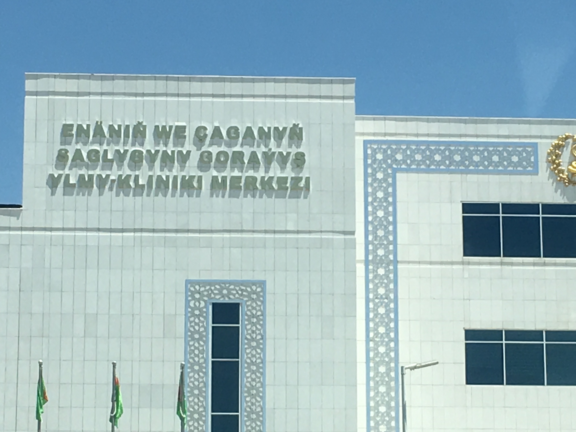
| 12:28, 1 July 2018 | TKM Pediatric-maternity-hospital.JPG (file) |  |
503 KB | Example of signage on a pediatric and maternity hospital in Ashgabat, Turkmenistan. Photo by Allan Mustard, taken 1 July 2018. | 1 |
| 03:09, 10 June 2018 | Dehistan archeological site.JPG (file) |  |
6.98 MB | Ruins of mosque and medressa at Dehistan, Balkan Province, Turkmenistan. Photo taken April 2017 by Allan Mustard. | 1 |
| 03:02, 10 June 2018 | Yangy Kala Canyon.jpg (file) |  |
307 KB | Yangy Kala Canyon from the outlook point. Photo taken by Allan Mustard. | 1 |
| 15:54, 9 June 2018 | TNO-AYGS-2.jpg (file) |  |
644 KB | Gas Station No. 2 in Ashgabat, Turkmenistan, of the Turkmen National Oil Products Company, TNO. Photo taken by Allan Mustard. | 1 |
| 15:20, 9 June 2018 | Koytendag-Lebap-Turkmenistan-dinosaur-footprints.JPG (file) |  |
5.92 MB | Dinosaur footprints approximately 130 million years old in the longest tracks of dinosaur footprints in the world near Koytendag, Lebap Province, Turkmenistan. Photo by Allan Mustard. | 1 |
| 15:13, 9 June 2018 | Dayahatyn-panorama-interior.jpg (file) | 2.63 MB | View from the inner courtyard of the Dayahatyn caravansaray approximately three hours' drive northwest of Turkmenabat, Turkmenistan. This is the best preserved Silk Road caravansaray in Central Asia, and has been conserved and partially reconstructed... | 1 | |
| 12:45, 9 June 2018 | White-Wheat-Museum.jpg (file) |  |
309 KB | White Wheat Museum in Anew, Turkmenistan, with statue of Turkmenistan's first president, Saparmyrat Niyazov. I took this photo and uploaded it to Mapillary. | 1 |
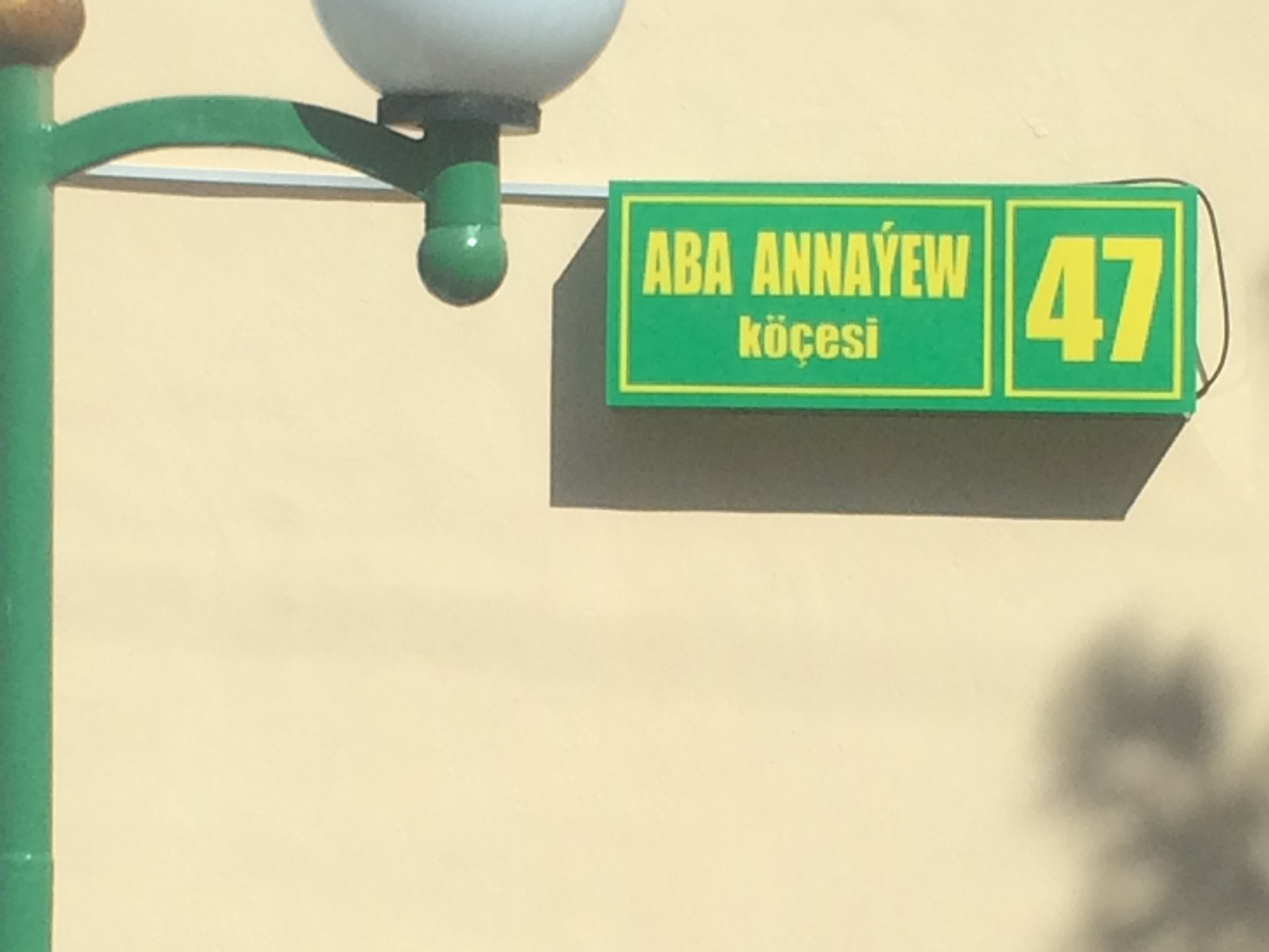
| 13:25, 19 May 2018 | Turkmenistan-sample-modern-street-sign.jpg (file) |  |
681 KB | Street sign from Aba Annaýew köçesi in Ashgabat. | 1 |
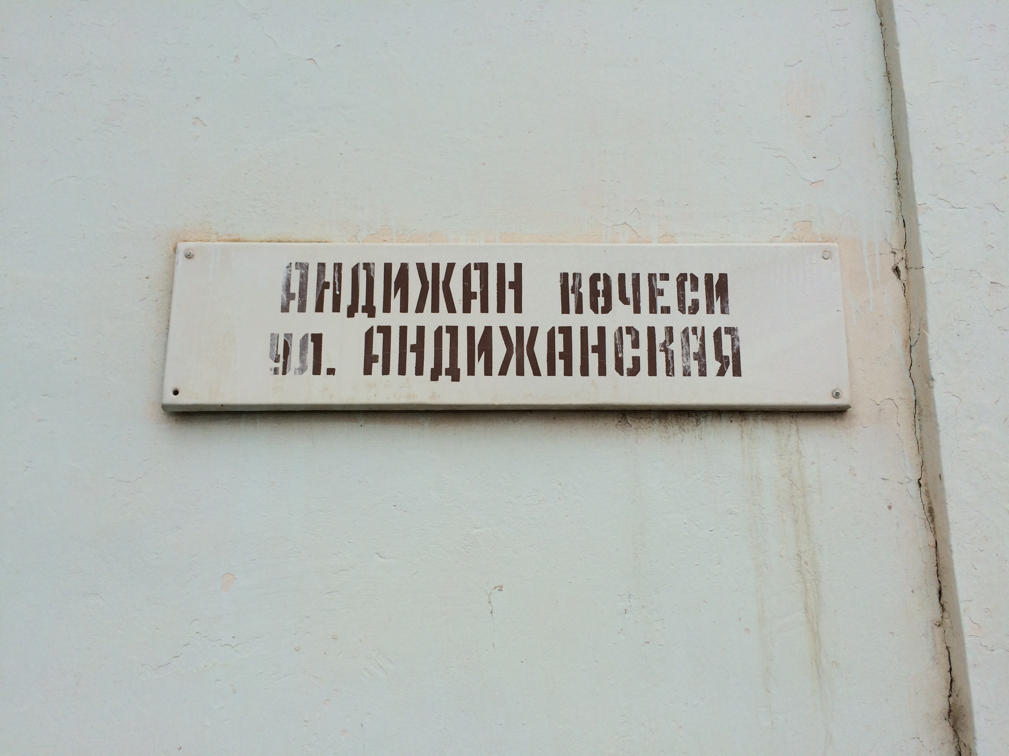
| 08:34, 19 May 2018 | Turkmenistan-sample-obsolete-bilingual-street-sign.jpg (file) |  |
1.37 MB | Obsolete sign for Andizhan Street in Ashgabat, Turkmenistan, in Turkmen Cyrillic and Russian Cyrillic. Such street signs are no longer used in Turkmenistan, which switched to the Latin alphabet in the first years of the 21st century. | 1 |