Tag:network=NL:ring
 |
| Description |
|---|
| Ring route in the Netherlands trunk road network |
| Group: routes |
| Used on these elements |
| Requires |
| Useful combination |
| See also |
| Status: in use |
| Tools for this tag |
|
This tag describes that a route=road relation is a ring route in the main national road network of the Netherlands, i.e. overlapping with A-roads and/or trunk N-roads.
The Richtlijnen Bewegwijzering - Deel I Autosnelwegen (1993) defines this route type as follows:
Ring
Circuit van auto(snel)wegen rondom of in een stad waarop in- en uitvalswegen aansluiten
toepassing van een Ring-aanduiding in de overgang van interlokale naar lokale bewegwijzering
Indien er rondom een stad een gesloten circuit van (auto)snelwegen ligt met zowel een functie voor het doorgaande verkeer als een (verdeel)functie voor het lokale verkeer dan verdient het aanbeveling dit stelsel van wegen aan te duiden met "Ring" met daaraan toegevoegd de naam van de stad. (...)
The tag can also be used for incomplete rings, i.e. boundary roads, which Richtlijnen Bewegwijzering - Deel I Autosnelwegen (1993) defines as follows:
Randweg
Weg die het doorgaande verkeer langs een bebouwde kom voert en waarop in- en uitvalswegen aansluiten
toepassing van een Randweg-aanduiding in de overgang van interlokale naar lokale bewegwijzering
(...) alle wijken in doorgaande richting zou leiden tot een te grote hoeveelheid informatie. In dat geval kan voor de doorgaande richting volstaan worden met de aanduiding "Randweg" met daaraan toegevoegd de naam van de bebouwde kom in kwestie.
The difference between ring and randweg will be self-evident from the name=* and/or ref=*. They look the same on road signs, and have similar importance and purposes in practice, so they can use the same value for network=*.
With the Nieuwe Bewegwijzering Autosnelwegen, Rijkswaterstaat introduced a new signposting style for these rings, indicating them directly in front of the A-road or N-road number. See below for example photos. Some road signs, particularly from other road operators, sometimes use older/different signposting styles.
There can only be a single such ring route per city, therefore it makes no sense to append the city name to the value of network=*. All routes with network=NL:ring thus share the same signposting style, but are not geographically related.
How to Map
| For rings signed with the RING symbol, use network=NL:binnenstedelijke_ring instead. Such inner-city rings are not part of the main national road network. |
| For individual S-roads signed like Centrumring S 100, do not create a separate ring route relation but simply use name=Centrumring S100 on the S-road relation. Such inner-city rings are not part of the main national road network. |
| Do not use ref=* if RING is never positioned within road signs as if it is part of the road numbers (followed by the A-road or N-road number). However, do use ref=* if this applies only to part of the route (e.g. only the non-motorway part of the ring). |
The way to tag Dutch road relations is explained at the page The Netherlands road network.
Map the entire ring route as a single relation, even if different parts of the ring have different A-road and/or N-road numbers. The A-road and N-roads have separate route relations, that can overlap with the ring route relation.
Signposting examples of ring route relations that should be tagged with network=NL:ring (photos in accordance with the Nieuwe Bewegwijzering Autosnelwegen except when indicated otherwise):
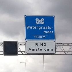
For a ring route announced as RING Amsterdam add name=Ring Amsterdam to the ring route relation.
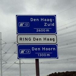
For a ring route announced as RING Den Haag add name=Ring Den Haag to the ring route relation.
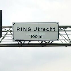
For a ring route announced as RING Utrecht add name=Ring Utrecht to the ring route relation.
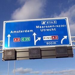
For a ring route signed as RING A 2 and similar with other road numbers (where RING serves as an additional road reference) add ref=RING to the ring route relation. A 2 and the other road numbers are separate route relations.
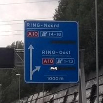
Cardinal direction indications are not used for mapping the ring route relation. They are often not signed along the ring as clearly distinguishable sections. (Amsterdam is a positive exception.)


See also
- The Netherlands road network#Interlocal_ring_roads - List of road relations for Dutch main ring routes