Proposal talk:Mountains
Mountain Range - Gebirge
To specify: I think, that mountain ranges can be mapped as way, along the highest ridges. (Custom) rendering should draw the name along this line, as topographic maps already do.
Following a post in the German Forum, mountain ranges should be tagged as a polygon/relation and mountains inside are part of the relation.
See: http://forum.openstreetmap.org/viewtopic.php?id=16094&p=2
Example: http://geo.dianacht.de/topo/?zoom=11&lat=47.3947&lon=11.29501&layers=B0000FFFFT.
- Tagging today - taginfo 3 June 2012
- natural=mountain_range: 13
- place=region, region:type=mountain_area: 89
--Federico Explorador 15:12, 3 June 2012 (BST)
-
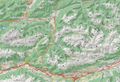 Example Karwendel

Grat und Rücken
- Wording
What is the difference of:
- ridge
- crest
- arete
a picture says more than 1000 words...
-
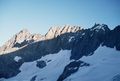 arete ?
 -
 ridge ?

- Yes. On first picture shows natural=arete? on second — natural=ridge. But in general case line natural=arete can be part of line (mapped by relation) natural=ridge. Lzhl 19:24, 30 March 2012 (BST).
- Drawing
How to draw a ridge? - If it is broad, where we draw the "line"? Or is it better to draw a hight curve?
- I think that ridge should be mapped as way by its highest curve. Lzhl 19:24, 30 March 2012 (BST).
- Tagging according to taginfo (3 June 2012)
- natural=ridge: 1642
- ridge=yes: 290
- natural=arete: 140 --Federico Explorador 17:21, 3 June 2012 (BST)
Tal, Schlucht,
- Wording
If we have a crest/arete, we need the opposite...
- valley
- gorge
- notch
- dale
- couloir
-
 Couloir
 -
 Valley
 -
 Gorge
Gorge


- Drawing
How a valley-line could be draw? If there is a river it is clear. Also a gorge, you can see it in the DOP. But if there is no river? and if it is more flat?
- Rendering
How a valley-line could be rendered? Showing the opposite of a ridge...
sidearm, subpeak, i-dont-know

This is not a peak, it's more like a sidearm. I won't consider it a subpeak either because it is not a local maximum next to the summit but in the Harz Mountains they have names. Most of them have names ending on ~kopf (head). Their names are used to describe the vicinity so they should be mapped. I dont know how that is called in english so what could be an appropriate tag for that? It might also be a good idea to describe to which moutain (peak) it belongs.