File:Anibaeza.gif
Jump to navigation
Jump to search


No higher resolution available.
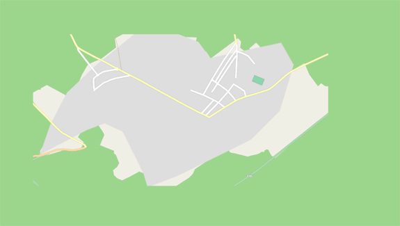
Anibaeza.gif (575 × 325 pixels, file size: 431 KB, MIME type: image/gif, looped, 24 frames, 15 s)
![]() << ( bigger - full resolution )
<< ( bigger - full resolution )
This is a Featured image, which means that it has been identified as one of the best examples of OpenStreetMap mapping, or that it provides a useful illustration of the OpenStreetMap project. If you know another image of similar quality, you can nominate it on Featured image proposals.
Front-page image for week 26 of 2011 (27 Jun. – 3 Jul.).
- Image descriptions
- čeština : Animace zobrazuje vývoj Jaén_Mapping_Party [1] (více než 100 lidí, 3h průzkum. Organizováno Španělskými orgány veřejné správy: Diputación de Jaén, Ayuntamiento Baeza, IDEJaén, CNIG, Junta de Andalucía, Universidad de Jaén...)
- Deutsch : Eine Animation, die den Verlauf der Mapping Party in Jaén [2] wiedergibt. Über 100 Teilnehmer waren anwesend, die 3 Stunden im Gelände die Daten erfassten. Organisiert wurde die Party mit Unterstützung der folgenden spanischen Behörden: Diputación de Jaén, Ayuntamiento Baeza, IDEJaén, CNIG, Junta de Andalucía, Universidad de Jaén...)
- English : Animation showing progress of Jaén_Mapping_Party [3] (over 100 people 3h. survey. Organized with Spanish Public Administrations: Diputación de Jaén, Ayuntamiento Baeza, IDEJaén, CNIG, Junta de Andalucía, Universidad de Jaén...)
- français : Animation montrant les progrès de la Jaén_Mapping_Party [4] (évenement de plus de 100 personnes pendant 3 h. organisée avec les administrations publiques espagnoles : Diputación de Jaén, Ayuntamiento Baeza, IDEJaén, CNIG, Junta de Andalucía, Universidad de Jaén...)
- italiano : Animazione che visualizza il progresso del Jaén_Mapping_Party [5] (più di 100 persone ed organizzato con il contributo delle amministrazioni pubbliche spagnole: Diputación de Jaén, Ayuntamiento Baeza, IDEJaén, CNIG, Junta de Andalucía, Universidad de Jaén...)
- русский : Отображение прогресса Картовстречи в Хаэне (исп. Jaén) [6] (более 100 человек и организованные Испанские государственные администрации: Депутация Хаэна, муниципалитет Баеза, Национальный центр по географической информации, Совет Андалусии, Университет Хаэн...).
- 中文(简体) : 哈恩图客趴[7]的动画显示画地图进度。 (超过100人花3小时踏察,由西班牙公共当局策画:Diputación de Jaén、Ayuntamiento Baeza、IDEJaén, CNIG、Junta de Andalucía、Universidad de Jaén等)
- 中文(繁體) : 哈恩圖客趴[8]的動畫顯示畫地圖進度。(超過100人花3小時踏察,由西班牙公共當局策畫:Diputación de Jaén、Ayuntamiento Baeza、IDEJaén, CNIG、Junta de Andalucía、Universidad de Jaén等)
Licensing
![]()
![]()
![]()
This screenshot contains OpenStreetMap Carto rendering.
The OpenStreetMap Carto map style is made available under the Creative Commons CC-0 1.0 Universal Public Domain Dedication.
- Attribution to the map data:
![]()
Contains map data © OpenStreetMap contributors, made available under the terms of the Creative Commons Attribution-ShareAlike 2.0 (CC-BY-SA-2.0).
File history
Click on a date/time to view the file as it appeared at that time.
| Date/Time | Thumbnail | Dimensions | User | Comment | |
|---|---|---|---|---|---|
| current | 11:05, 6 June 2011 | | 575 × 325 (431 KB) | Sergionaranja (talk | contribs) | |
| 18:05, 29 April 2011 | 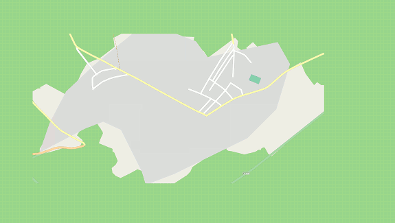 | 575 × 325 (164 KB) | Sergionaranja (talk | contribs) |
You cannot overwrite this file.
File usage
The following 23 pages use this file:
- Community Updates/2011-06-27
- Fa:Pick your mapping technique
- Featured images/Apr-Jun 2011
- Ko:데이터 수집 방법 고르기
- List of featured images/2011
- Ms:Pick your mapping technique
- Pick your mapping technique
- Sv:Pick your mapping technique
- Uk:Оберіть власний стиль мапінгу
- Zh-hant:選擇你的繪製方法
- Template:DE:Featured image p2
- Template:FR:Featured image p2
- Template:Featured image p2
- Template:Iotw image/2011-26
- DE:Featured images/Apr-Jun 2011
- FR:Choisir votre méthode de collecte de données
- FR:Featured images/Apr-Jun 2011
- ES:Escoge tu técnica de mapeo
- ES:Escoge tu técnica de recopilación de datos
- ES:Jaén Mapping Party
- IT:Featured images/Apr-Jun 2011
- NL:Pick your mapping technique
- JA:データ収集手法を選ぶ