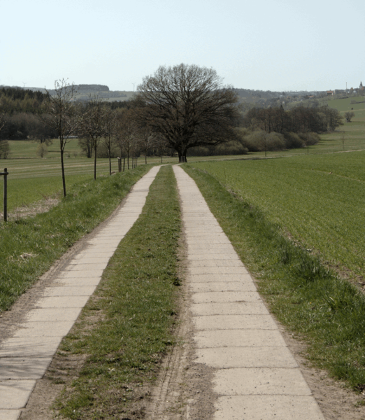
File:Concrete lanes.png
Jump to navigation
Jump to search


Size of this preview: 522 × 600 pixels. Other resolutions: 209 × 240 pixels | 579 × 665 pixels.
Original file (579 × 665 pixels, file size: 233 KB, MIME type: image/png)
Summary
(South Frischborn rural area ( 50.5908917 (50° 35' 27.21") / 9.3558400 (9° 21' 21.02" looking west). Example for concrete lanes - track road (part of bicycle route: Hessischer Radfernweg R7 - Way 32911341)
Licensing
This work is licensed under the Creative Commons Attribution-ShareAlike 2.0 License.
Attribution not specified as a parameter! THIS LICENSE ALWAYS REQUIRES ATTRIBUTION! Use {{CC-BY-SA-2.0|Attribution, typically name of author}} See Template:CC-BY-SA-2.0 for full description how this template should be used.
Note, there is
There is also
Attribution not specified as a parameter! THIS LICENSE ALWAYS REQUIRES ATTRIBUTION! Use {{CC-BY-SA-2.0|Attribution, typically name of author}} See Template:CC-BY-SA-2.0 for full description how this template should be used.
Note, there is
{{CC-BY-SA-2.0 OpenStreetMap}} for files based on old OSM map data, before the license change made on 2012-09-12.There is also
{{OSM Carto screenshot||old_license}} for files based on old OSM map data, before the license change made on 2012-09-12, created using OSM Carto map style.
File history
Click on a date/time to view the file as it appeared at that time.
| Date/Time | Thumbnail | Dimensions | User | Comment | |
|---|---|---|---|---|---|
| current | 20:10, 10 April 2011 |  | 579 × 665 (233 KB) | Bmog (talk | contribs) | (South Frischborn rural area ( 50.5908917 (50° 35' 27.21") / 9.3558400 (9° 21' 21.02" looking west). Example for concrete lanes - track road (part of bicycle route: Hessischer Radfernweg R7 - Way 32911341) |
You cannot overwrite this file.
File usage
The following 48 pages use this file:
- Cs:Key:surface
- Da:Key:surface
- El:Key:surface
- Fi:Key:surface
- Hu:Key:surface
- Key:surface
- Pl:Key:surface
- Pl:Tag:surface=concrete:lanes
- Pt:Key:surface
- Tag:surface=concrete:lanes
- Tag:surface=paving stones
- Tag:surface=sett
- Uk:Key:surface
- Zh-hans:Key:surface
- User:H4ck3rm1k3/OSMKeys
- User:Haribo/Surfaces
- User:John07/wegbeschaffenheit/en
- Wiki:Files used by data items/1
- Template:Az:Map Features:surface
- Template:Cs:Map Features:surface
- Template:DE:Map Features:surface
- Template:Da:Map Features:surface
- Template:FR:Map Features:surface
- Template:Generic:ES:Map Features:surface
- Template:Hu:Map Features:surface
- Template:IT:Map Features:surface
- Template:JA:Map Features:surface
- Template:Map Features:surface
- Template:NL:How to map a:B
- Template:NL:Map Features:surface
- Template:Pl:Map Features:surface
- Template:Pt:Map Features:surface
- Template:RU:Map Features:surface
- Template:Uk:Map Features:surface
- Template:Zh-hans:Map Features:surface
- DE:Key:surface
- DE:Key:tracktype
- DE:Tag:surface=concrete:lanes
- FR:Key:surface
- FR:Tag:surface=sett
- ES:Tag:surface=concrete:lanes
- IT:Key:surface
- NL:Key:surface
- RU:Key:surface
- RU:Объекты карты
- JA:Key:surface
- JA:Tag:surface=concrete:lanes
- JA:Tag:surface=paving stones