File:Fredy Rivera mapping mountain tracks.jpg
Jump to navigation
Jump to search


Size of this preview: 800 × 600 pixels. Other resolutions: 320 × 240 pixels | 640 × 480 pixels | 1,024 × 768 pixels.
Original file (1,024 × 768 pixels, file size: 226 KB, MIME type: image/jpeg)
Summary
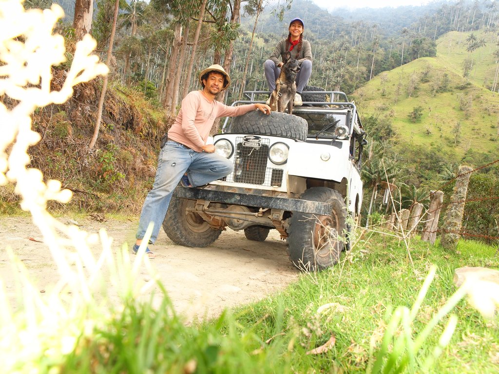
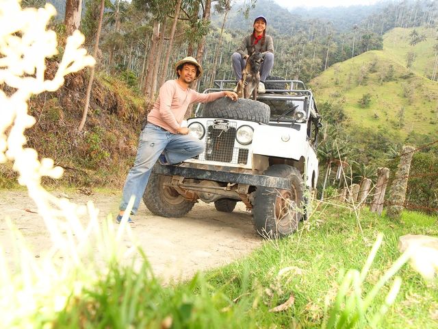
Columbian mapper Fredy Rivera likes to take his 4x4 and map mountain trails for OpenStreetMap. With such stunning scenery in the Andes, who can blame him?! Fredy was featured in this mapper in the spotlight. blog post
License permission: https://twitter.com/fredy_rivera/status/690530238825107463
This is a Featured image, which means that it has been identified as one of the best examples of OpenStreetMap mapping, or that it provides a useful illustration of the OpenStreetMap project. If you know another image of similar quality, you can nominate it on Featured image proposals.
Front-page image for week 17 of 2016 (25 Apr. – 1 May).
- Image descriptions
- English : Colombian mapper Fredy Rivera likes to take his 4x4 and map mountain trails for OpenStreetMap. With such stunning scenery in the Andes, who can blame him?! Fredy was featured in this mapper in the spotlight blog post.
- italiano : Il mappatore colombiano Fredy Rivera ama prendere la sua 4x4 e mappare i percorsi di montagna per OpenStreetMap. Con panorami stupefacenti come quelli delle Ande, chi lo può biasimare? Fredy è stato intervistato in questo post del blog Mapper in the Spotlight.
- русский : Участник ОСМа из Колумбии Фреди Ривера — любитель картировать горные дороги на своём внедорожнике. Как тут его упрекнуть, когда вокруг такой отличный пейзаж?! Недавний выпуск «Картограф в центре внимания» был именно о Фреди. Посмотрите.
- 中文(简体) : 哥伦比亚图客Fredy Rivera喜欢开着他的4x4为开放街图绘制山径。有如此壮阔景观的安地斯山脉,谁能怪他呢?! Fredy在这一篇 图客焦点部落格文章详细介绍。
- 中文(繁體) : 哥倫比亞圖客Fredy Rivera喜歡開著他的4x4為開放街圖繪製山徑。有如此壯闊景觀的安地斯山脈,誰能怪他呢?! Fredy在這一篇 圖客焦點部落格文章詳細介紹。
Licensing
![]()
![]()
![]()
This work is licensed under the Creative Commons Attribution-ShareAlike 2.0 License.
Attribution not specified as a parameter! THIS LICENSE ALWAYS REQUIRES ATTRIBUTION! Use {{CC-BY-SA-2.0|Attribution, typically name of author}} See Template:CC-BY-SA-2.0 for full description how this template should be used.
Note, there is
There is also
Attribution not specified as a parameter! THIS LICENSE ALWAYS REQUIRES ATTRIBUTION! Use {{CC-BY-SA-2.0|Attribution, typically name of author}} See Template:CC-BY-SA-2.0 for full description how this template should be used.
Note, there is
{{CC-BY-SA-2.0 OpenStreetMap}} for files based on old OSM map data, before the license change made on 2012-09-12.There is also
{{OSM Carto screenshot||old_license}} for files based on old OSM map data, before the license change made on 2012-09-12, created using OSM Carto map style.
File history
Click on a date/time to view the file as it appeared at that time.
| Date/Time | Thumbnail | Dimensions | User | Comment | |
|---|---|---|---|---|---|
| current | 10:40, 25 April 2016 | | 1,024 × 768 (226 KB) | Harry Wood (talk | contribs) | Columbian mapper Fredy Rivera likes to take his 4x4 and map mountain trails for OpenStreetMap. With such stunning scenery in the Andes, who can blame him?! Fredy was featured in this [mapper in the spotlight. blog post] License permission: https://twi... |
You cannot overwrite this file.