File:OSM Analytics Haiti buildings.png
Jump to navigation
Jump to search


Size of this preview: 800 × 539 pixels. Other resolutions: 320 × 216 pixels | 640 × 431 pixels | 1,006 × 678 pixels.
Original file (1,006 × 678 pixels, file size: 452 KB, MIME type: image/png)
Summary
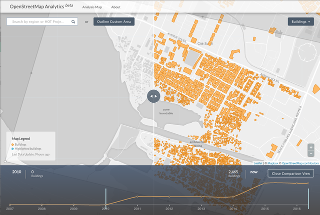
Screenshot of the OSM Analytics tool showing buildings in Haiti
http://osm-analytics.org/#/compare/polygon:xxpxLwqjpBwzAfTqCkr%40jpAaP/2010...now/buildings
This is a Featured image, which means that it has been identified as one of the best examples of OpenStreetMap mapping, or that it provides a useful illustration of the OpenStreetMap project. If you know another image of similar quality, you can nominate it on Featured image proposals.
Front-page image for week 19 of 2016 (9–15 May).
- Image descriptions
- English : The new OSM Analytics tool showing progress with mapping buildings in Haiti, by comparing on a timeline, and with a visual side-by-side map slider.
- italiano : Il nuovo strumento OSM Analytics mostra l'avanzamento della mappatura degli edifici ad Haiti confrontandolo su una linea temporale e visualizzando mappe affiancate con un cursore.
- русский : ОСМ-Аналитика (OSM Analytics) — это инструмент для визуализации и анализа процесса картирования. Снимок экрана показывает здания на Гаити в формате до/после, а временная шкала под картой отображает динамику изменений.
- 中文(简体) : 新的开放街图分析工具能够搭配时间轴以及视觉化的比对滑轨,显示海地一带画建筑物的进度。
- 中文(繁體) : 新的開放街圖分析工具能夠搭配時間軸以及視覺化的比對滑軌,顯示海地一帶畫建築物的進度。
Licensing
![]()
![]()
![]()
This work is licensed under the Creative Commons Attribution-ShareAlike 2.0 License.
Attribution not specified as a parameter! THIS LICENSE ALWAYS REQUIRES ATTRIBUTION! Use {{CC-BY-SA-2.0|Attribution, typically name of author}} See Template:CC-BY-SA-2.0 for full description how this template should be used.
Note, there is
There is also
Attribution not specified as a parameter! THIS LICENSE ALWAYS REQUIRES ATTRIBUTION! Use {{CC-BY-SA-2.0|Attribution, typically name of author}} See Template:CC-BY-SA-2.0 for full description how this template should be used.
Note, there is
{{CC-BY-SA-2.0 OpenStreetMap}} for files based on old OSM map data, before the license change made on 2012-09-12.There is also
{{OSM Carto screenshot||old_license}} for files based on old OSM map data, before the license change made on 2012-09-12, created using OSM Carto map style.
| Contains map data © OpenStreetMap contributors, made available under the terms of the Open Database License (ODbL).
The ODbL does not require any particular license for maps produced from ODbL data, produced maps may be subject also to other licences. |
File history
Click on a date/time to view the file as it appeared at that time.
| Date/Time | Thumbnail | Dimensions | User | Comment | |
|---|---|---|---|---|---|
| current | 00:09, 9 May 2016 | | 1,006 × 678 (452 KB) | Harry Wood (talk | contribs) | Screenshot of the OSM Analytics tool showing buildings in Haiti http://osm-analytics.org/#/compare/polygon:xxpxLwqjpBwzAfTqCkr%40jpAaP/2010...now/buildings |
You cannot overwrite this file.
File usage
The following 14 pages use this file:
- Featured images/Apr-Jun 2016
- List of featured images/2016
- OSM Analytics
- Pt:OSM Analytics
- User:Tyr
- Template:Iotw image/2016-19
- DE:Featured images/Apr-Jun 2016
- FR:Featured images/Apr-Jun 2016
- FR:OSM Analytics
- ES:Featured images/Apr-Jun 2016
- ES:OSM Analytics
- IT:Featured images/Apr-Jun 2016
- RU:OSM Analytics
- JA:OSM Analytics