File:Wetter Atlantiksturm.png
Jump to navigation
Jump to search


Size of this preview: 791 × 600 pixels. Other resolutions: 317 × 240 pixels | 633 × 480 pixels | 1,013 × 768 pixels | 1,198 × 908 pixels.
Original file (1,198 × 908 pixels, file size: 393 KB, MIME type: image/png)
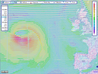
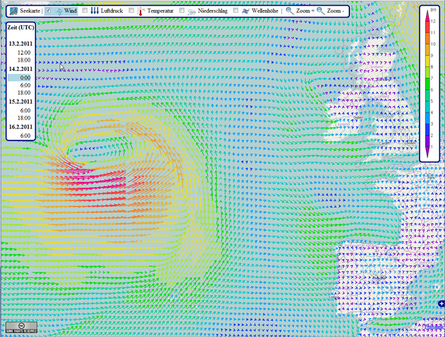
Storm in Nordatlantic 14.2.2011 Weather forecast
This is a Featured image, which means that it has been identified as one of the best examples of OpenStreetMap mapping, or that it provides a useful illustration of the OpenStreetMap project. If you know another image of similar quality, you can nominate it on Featured image proposals.
Front-page image for week 9 of 2011 (28 Feb. – 6 Mar.).
- Image descriptions
- Alemannisch : Wettervorhersage in OpenSeaMap:
Sturm im Nordatlantik. Rendering von bluewater-info.net. Windrichtung und -Stärke, Luftdruck, Lufttemperatur, Niederschlag, Wellenhöhe - corsu : Una tempesta nel nord Atlantico visualizzata da OpenSeaMap. I dati sono stati messi a disposizione dagli USA e rappresentati graficamente da bluewater-info.net.
- Deutsch : Wettervorhersage in OpenSeaMap:
Sturm im Nordatlantik. Rendering von bluewater-info.net. Windrichtung und -Stärke, Luftdruck, Lufttemperatur, Niederschlag, Wellenhöhe - eesti : OpenSeaMap kaardil on näha torm Põhja-Atlandil. Andmed on saadud USAlt ja renderdaja on bluewater-info.net.
- English : OpenSeaMap showing a storm in the North Atlantic. Data provided by US and rendered by bluewater-info.net.
- français : OpenSeaMap illustrant une tempête sur l'Atlantique Nord. Données fournies par US, rendu par bluewater-info.net.
- italiano : Una tempesta nel nord Atlantico visualizzata da OpenSeaMap. I dati sono stati messi a disposizione dagli USA e rappresentati graficamente da bluewater-info.net.
- Kreyòl ayisyen : OpenSeaMap illustrant une tempête sur l'Atlantique Nord. Données fournies par US, rendu par bluewater-info.net.
- Lëtzebuergesch : Wettervorhersage in OpenSeaMap:
Sturm im Nordatlantik. Rendering von bluewater-info.net. Windrichtung und -Stärke, Luftdruck, Lufttemperatur, Niederschlag, Wellenhöhe - lietuvių : OpenSeaMap rodo šiaurės atlanto audrą. Duomenis suteikė US, o atvaizduota pagal bluewater-info.net.
- Malagasy : OpenSeaMap illustrant une tempête sur l'Atlantique Nord. Données fournies par US, rendu par bluewater-info.net.
- occitan : OpenSeaMap illustrant une tempête sur l'Atlantique Nord. Données fournies par US, rendu par bluewater-info.net.
- Plattdüütsch : Wettervorhersage in OpenSeaMap:
Sturm im Nordatlantik. Rendering von bluewater-info.net. Windrichtung und -Stärke, Luftdruck, Lufttemperatur, Niederschlag, Wellenhöhe - polski : Sztorm nad północnym Atlantykiem w OpenSeaMap. Dane udostępnione przez Stany Zjednoczone i renderowane przez bluewater-info.net.
- vèneto : Una tempesta nel nord Atlantico visualizzata da OpenSeaMap. I dati sono stati messi a disposizione dagli USA e rappresentati graficamente da bluewater-info.net.
- Wolof : OpenSeaMap illustrant une tempête sur l'Atlantique Nord. Données fournies par US, rendu par bluewater-info.net.
![]()
This media file does not have sufficient information on its copyright status. If you have created this file yourself, or the file is available under some open licence allowing its use on OSM Wiki or the file is in the public domain, you can edit the file description page to license it under one of the allowed licences. If you did not create it and it is not in the public domain, you must ask the copyright holder for permission to release it under one of the allowed licenses. Wiki:Media file license chart may be helpful to find a suitable licence.
• Files without licences marked with this template are listed in Category:Media without a license or one of its subcategories.
• If the file is without a known open licence: Ask its uploader to clarify situation or find a replacement and replace its uses. In case of a replacement from Wikimedia Commons, mark file with {{Superseded by Commons}}.
• If uploader was notified this month: Use
• If no action taken helped or the file is a known copyright violation then you should remove its uses and mark the file with {{Delete}}.
• Files without licences marked with this template are listed in Category:Media without a license or one of its subcategories.
• If the file is without a known open licence: Ask its uploader to clarify situation or find a replacement and replace its uses. In case of a replacement from Wikimedia Commons, mark file with {{Superseded by Commons}}.
• If uploader was notified this month: Use
{{No licence|subcategory=uploader notified 2024, September}} – to put media into Category:Media without a license - uploader notified 2024, September and mark image as one where uploader was notified.• If no action taken helped or the file is a known copyright violation then you should remove its uses and mark the file with {{Delete}}.
File history
Click on a date/time to view the file as it appeared at that time.
| Date/Time | Thumbnail | Dimensions | User | Comment | |
|---|---|---|---|---|---|
| current | 14:25, 13 February 2011 | | 1,198 × 908 (393 KB) | Markus B (talk | contribs) | Storm in Nordatlantic 14.2.2011 Weather forecast |
You cannot overwrite this file.
File usage
The following 9 pages use this file: