Key:step_count
 |
| Description |
|---|
| Number of individual steps in a stair, part of a stair or on a stile. |
| Group: properties |
| Used on these elements |
| Requires |
| Status: approved |
| Tools for this tag |
|
The key step_count=* gives the number of individual steps for a way tagged with highway=steps.
The key is also used with various kinds of barrier=stile (q.v.) notably stepover and ladder stiles, and sometimes squeezer stiles to denote the number of steps one has to take to get to the top of the stile.
Examples
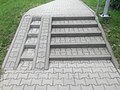
Simple stairs with 5 steps leading up to a door
highway=steps
step_count=5
width=2
Elegant stairs with 23 steps
highway=steps
step_count=23
Stile with a dog gate
barrier=stile
stile=stepover
step_count=1


Use cases
- Navigation software for blind persons can tell the number of steps, see OSM for the blind.
- Navigation and routing software for wheelchair drivers avoids steps. Profiles for persons with a walking handicap can allow single steps but avoid staircases etc., see Wheelchair routing.
- CycleStreets uses the step count, as in some cases it is better to carry a bike over a few steps, than to cycle a much bigger route.
- OSM2World uses this tag to render the correct number of steps in its 3d visualization.
- This is currently not used by any known 2d rendering application. A very detailed rendering could include this value as a number on or near the steps.
- Step count on stiles can be an aid to estimating accessibility for people with some limitations in mobility (e.g., older people).
Note that in many cases step count can be estimated from length of a way. For example 30m long steps are clearly an obstacle for older people, adding step_count=80 is not adding more info in that aspect.
Alternative tagging
steps=* is also used with usually the same semantics. This latter key is more popular in usage on stiles, but has also been used for other, adjectival tagging, values (yes, no, escalator). Step_count is to be preferred as it is not ambiguous.
You can complement the step_count=* key with separate barrier=step nodes along the way. These nodes can indicate uneven spacing or variations in surface or color along the flight of steps. Unlike the step_count=* key, step nodes remain accurate after splitting a highway=steps way.
See also
- Approved features/Number of steps – proposal with voting and original discussion
- handrail=*
- tactile_paving=*
- incline=* - incline records whether steps upward or downward