Ko:Tag:waterway=tidal_channel
![]()
영어 원본의 내용을 이해할 수 있다면 번역 완료에 힘을 모아 주십시오. 번역 방법에 대해서는 위키 번역 방법에 대한 설명을 읽어주시길 바랍니다. 만약 이 문서의 번역이 충분하다고 판단되면 이 틀을 지워주시길 바랍니다.
이 즈음에는 맡아서 번역을 하는 사람이 없기 때문에, 당신이 이 작업을 해 줄 수 있습니다.
![]()
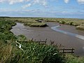
_(3587499039).jpg) |
| 설명 |
|---|
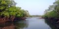
| 갯골. 바닷물이 드나드는 갯가에 미세기로 생긴 두둑한 땅 사이의 좁고 길게 들어간 곳의 물길 |
| 그룹: 수로 |
| 해당 요소의 사용 |
| 함축하는 의미 |
|
| 유용한 조합 |
| 같이 보기 |
| 상태:인가됨 |
| 이 태그를 위한 도구 |
갯벌에서 미세기(조수 간만)에 따라 바닷물이 흐르는 자연스런 물길에는 waterway=tidal_channel을 씁니다. 이러한 물길은 일반적으로 갯벌, 염습지 또는 맹그로브 숲 안에서 파도의 작용이 제한적이고 완만한 경사를 가진 보호된 해안을 따라 형성됩니다.
이러한 물길은 염분 농도가 높고 밀물 때 바다에서 멀어지는 물의 흐름이 썰물 때 바다로 향하는 물의 흐름과 같기 때문에 강과 구별할 수 있습니다.
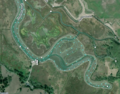
강하구와 갯골
Tidal channels are frequently found along coastlines with a gentle slope where the salt marsh, mangroves, or tidal flats are protected from wave action. In these areas, many branching channels may be found, which can appear to create networks similar to rivers and streams. However, these are not rivers: they usually contain salt water which flows away from the sea at high tide and towards the sea at low tide.
Some tidal channels connect to an estuary of a river and may be less salty than the sea, since the connect to the estuary. But in contrast to a river estuary, in a tidal channel the water flowing towards the sea at low tide is often slightly higher in salinity than the open sea water, due to evaporation, especially in mangroves and subtropical salt marshes. Unlike in a river estuary, the flow of water towards the sea at low tide is not significantly greater than the flow away from the sea at high tide in a tidal channel. By following the channel away from the sea, or observing the flow of water at low tide and high tide, it is apparent if the waterway is the estuary of a river, or a tidal channel.
Many tidal channels are currently mistagged as waterway=river, waterway=stream, natural=bay, or natural=water areas, and could be updated to this tag.
매핑 방법
- To map a tidal channel, make a simple linear
 way and add the waterway=tidal_channel tag to it. The direction of the way should be towards the sea (i.e. the direction of water flow at low tide).
 - The centreline of a tidal channel should be outside of the coastline (natural=coastline), because this is a marine water body, below the high tide line.
- In mangroves, the natural=coastline is often drawn at the border of the open water at the ends of the tidal channel, but sometimes is drawn farther inland. In either case, the end of the mangroves should be drawn up to the edge of the open water in the tidal channel.
- In salt marshes and tidal mud flats, the borders of the tidal channel will still be outside of the coastline, but may be drawn as the outer limit of the natural=wetland.
- In tidal flats, tidal channels may only be visible at low tide. In these cases the tag should generally be reserved for named tidal channels, or those that are significant for navigation.
덧 태그
- name=* to specify the name of the tidal channel; for example, Big Creek.
- width=* to indicate the width of the channel in meters. This is an approximate average width of the channel throughout most of the length of that part of the waterway.
- salt=yes/no to indicate whether the water is salty.
- intermittent=yes to indicate the waterway is dry at low tide.
보기
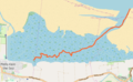
- Tidal channels in tidal mud flats, in Germany
- OSM Way 401730958
- name = Kronenloch
- waterway=tidal_channel
- OSM Way 401730966
- name = Wöhrdener Loch
- waterway=tidal_channel
- The edges of the tidal channel are mapped as the end of the wetland=tidalflat
- OSM Way 401730958
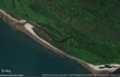
- Tidal channel in mud flats, in Scotland
- OSM way 694300595
- name = Barbara Channel
- waterway=tidal_channel
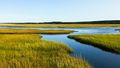
- Tidal creek in salt marshes, in England:
- OSM way 121698431
- name = Cabbage Creek
- Note that the edge of the open water is mapped as the border of the wetland=saltmarsh
- Tidal channel in mangroves, in Indonesia
- OSM way 694868357
- waterway=tidal_channel
- The wetland=mangrove ends at the edges of the tidal channel, which is also set as the coastline


비슷한 지물
- For an artificial (man-made) small watercourse, see waterway=ditch and waterway=drain.
- For a wider man-made watercourse created for navigation use waterway=canal.
- If the waterway is a natural estuary with lower salinity than the sea and a significantly greater flow of water toward the sea than away, use waterway=river
함께 보기
이미지 모음
Small tidal channel in a salt marsh
Cabbage Creek (orange line)
Tidal channel in mangroves
Tidal channels in a salt marsh
Tidal creek in mangroves
Hookton Slough, a channel in salt marshes
Channels in salt marsh, the Netherlands
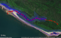
Mapping a tidal channel (red line with arrows) in mangroves with JOSM
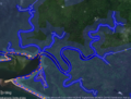
Large branching tidal channels in mangroves in JOSM

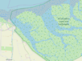
람사르 습지에 등록된 순천만 습지


