Tag:waterway=canal
 |
| Description |
|---|
| An artificial open flow waterway used to carry useful water for transportation, waterpower, or irrigation. |
| Rendering in OSM Carto |

|
| Group: waterways |
| Used on these elements |
| Useful combination |
| See also |
| Status: de facto |
| Tools for this tag |
|
Use waterway=canal for man-made open flow (free flow vs pipe flow) waterways used to carry useful water for transportation, hydro-power generation or irrigation purposes. The tag can also be used for underground free flow (with tunnel=*), not just above ground.
For a natural watercourse use waterway=river or waterway=stream. For water carried in pipes use man_made=pipeline. For small artificial waterways used for drainage see waterway=drain and waterway=ditch. For navigable route marked by buoys in large water bodies like a lake or a sea that are not canals or rivers use waterway=fairway.
How to Map
- See also: Waterways
Create a simple way in the direction of flow of the canal and tag it with waterway=canal. In order to allow routing, do ensure that the ends of the way connect correctly with and other related waterway features, including other canals, rivers, streams, lakes etc.
Just like a stream or river, ensure that the way points downhill. Although each 'pound' between locks seems perfectly flat, in reality streams will enter the canal at the uphill end and exit via weirs at the downhill end. The water is not stagnant, it is always slowly moving. Mapping the way direction in OSM, from high to low, helps to model this.
Sections with a lock should be tagged with lock=*, with nodes marked with waterway=lock_gate at each end.
Access for navigation by different vessels can be given using a variety of tags. Use boat=* to indicate that it can be used for a rowing-boat, motorboat=* for a motorboat, and canoe=* for access by canoes and kayaks. For more commercial navigation use CEMT=* in Europe and ship=* elsewhere.
Engineering features can be shown using cutting=*, embankment=*, bridge=aqueduct and tunnel=* as appropriate.
Consider adding width=* to indicate the width in metres, for example width=5.
You may also natural=water + water=canal to create an area for the canal in addition to the linear 'canal' feature along the centreline.
Use name=* and name:xx, for example name:fr=* for the name in the local language and also optionally in other languages.
Usage
Different usage=* values can be used to distinguish between transportation, water power, or irrigation.
Presentation
- Canals are drawn as blue lines on the standard Openstreetmap-Carto rendering style.
- They are rendered in dark green on the OpenRiverBoat tiles when they are navigable.

Photos
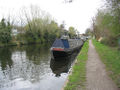
The Grand Union Canal in the UK.
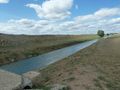
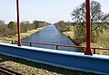
An irrigation canal.
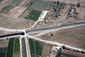
Aerial view of an irrigation canal in Iraq. Similar systems are used in other countries.


See also
- waterways: generic information about waterways
- waterway=*
- waterway=milestone
- water=canal
- Relation:waterway
- Approved proposal Proposed_features/Hydropower_water_supplies, which describes how waterway=canal fits with related terms
- canal=qanat and associated proposal Proposed features/Qanat; competing tag Tag:man made=qanat