Tag:waterway=lock_gate
Jump to navigation
Jump to search
 |
| Description |
|---|
| A gate of a lock |
| Rendering in OSM Carto |
| Group: waterways |
| Used on these elements |
| Useful combination |
|
| Status: de facto |
| Tools for this tag |
|
A ![]() Lock is a device for raising and lowering boats between stretches of water of different levels on river and canal waterways.
Lock is a device for raising and lowering boats between stretches of water of different levels on river and canal waterways.
How to map
Simply add two nodes ![]() to the waterway at the points where the top/bottom gate is located and add the tag waterway=lock_gate to both of them. Direction of the waterway should be downstream (from top to bottom gate).
to the waterway at the points where the top/bottom gate is located and add the tag waterway=lock_gate to both of them. Direction of the waterway should be downstream (from top to bottom gate).
It is also possible to map exact location of lock gate using way ![]() .
.
The mapping of a lock and its components is described on page lock=*.
Examples
| Picture/Description | Tags | OSM Carto |
|---|---|---|

|
two ways with the tag: |
 |
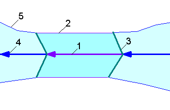
All features of a lock

- 1. Lock
- Separate the way
 of the waterway=* at the two lock gates. Mark the newly created section with
Seamark tags
See also
- barrier=coupure - a closable cut through a floodwall or a dyke
- waterway=sluice_gate - A movable gate to control water flow
- seamark:type=gate - Gate on a waterway (A structure that may be swung, drawn, or lowered to block an entrance or passageway.)
- lock=* - for the lock basin (Marks a stretch of waterway bounded by lock gates, forming a lock)
- Seamarks/Gates