Proposal:Tactile paving
| The Feature Page for the approved proposal Tactile paving is located at Key:tactile_paving |
| tactile_paving | |
|---|---|
| Proposal status: | Approved (active) |
| Proposed by: | Lulu-Ann |
| Tagging: | tactile_paving=yes/(no)
|
| Applies to: | node, way, area |
| Definition: | A paving in the ground to be followed with a blindman's stick. |
| Statistics: |
|
| Rendered as: | not rendered by default in visual maps |
| Draft started: | |
| Proposed on: | 2009-03-23 |
| RFC start: | 2009-04-24 |
| Vote start: | 2009-05-08 |
| Vote end: | 2009-06-17 |
Tactile Paving
The object of this proposal is to offer the new tag tactile_paving=yes/no for use with footways, platforms, bus stops and areas like market places.
A tactile paving is a line of different stones on a footway that has an easy to detect surface, often more rough than the surrounding ground.
See images on Wikipedia.
"incorrect" is used, if tactile paving is used but not in a sensible way, e.g. if the paving is symmetric for visual pleasure but on one of the sides it leads to nothing. See German page http://www.nullbarriere.de for examples of such cases.
"no" shall be tagged explicitely to ensure that the bus stop or other object has been checked for tactile paving and as an information for the blind that they do not need to search for it.
Typical combinations:
highway=bus_stophighway=crossingand other crossings like traffic lightshighway=footwayhighway=platformman_made=pierhighway=stepshighway=elevatorhighway=escalator
Tactile paving is also used near sloped curbs that are really flat, so the blind notice the end of the footway.
-
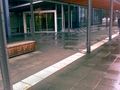
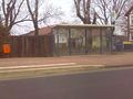 Tactile paving (white) at a bus stop.n Hannover, Germany.
 -

-
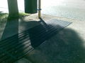 Australian bus stop showing two different tactile patterns
 -
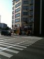 Japanese zebra crossing with tactile paving
 -
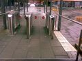 Incorrect
 -
 Incorrect
 -
 Tactile paving=guideway


Used on nodes
Examples: Bus stops,
Used on ways
Examples: tactile paving on footways, tactile paving leading over a pedestrian area
Used on areas
Examples: railway platforms
Used on relations
Examples: hiking trails for blind persons
Reasonable
Tactile pavings are often installed when a footway is newly built or repaved to fit modern accessibility recommendations. They will be a valuable information for routing software and maps for the blind and visually impaired.
Rendering
Tactile paving does not need to be rendered on visual maps by default. It will be used for tactile maps and acoustic routing software for pedestrians.
NEW: There is a visual map for features for the blind: blindmap.
[ dead link ]
[ dead link ]
- HaptoRender - Tactile OSmaps for the blind.
- LoroDux - Pedestrian navigation software for the blind
- Loadstone - GPS tool for the blind, able to import OSM POIs and crossings.
Comments
Please add your comments on the discussion page.
See also
tourism=informationwithinformation=tactile_map- Category:Visual Impairment
- OSM for the blind
- LoroDux - Pedestrian routing software for the blind
- HaptoRender - Haptic (tactile) maps for the blind
Voting starts on 2009-05-08
 I approve this proposal. --Lulu-Ann 10:03, 7 May 2009 (UTC)
- I approve this proposal. --Pobice 11:03, 7 June 2009 (UTC)
- I approve this proposal. --Divjo 13:21, 7 June 2009 (UTC)
- I approve this proposal. --Peter Dörrie 11:34, 7 June 2009 (UTC)
- I approve this proposal. --motp 12:10, 7 June 2009 (UTC)
- I approve this proposal, if it can be used in nodes such as
amenity=bankamenity=post_officeand other as well. --Skippern 11:53, 7 June 2009 (UTC) - I approve this proposal. --Jesuzphreak 12:42, 7 June 2009 (UTC)
- I approve this proposal. --Dieterdreist 16:28, 7 June 2009 (UTC)
- I approve this proposal. (This is a good start, BUT the tag-value "irritating" needs documentation and someone with knowledge in the field should start collecting values for a tactile_pavine_type=*) --MarcusWolschon 08:54, 8 June 2009 (UTC)
- I approve this proposal. --Henselfamily 09:35, 8 June 2009 (UTC)
- I approve this proposal. --Tordanik 14:51, 8 June 2009 (UTC)
- I approve this proposal. EtienneChove 10:54, 9 June 2009 (UTC)
- I approve this proposal. --Stefan Bethke 21:23, 11 June 2009 (UTC)
- I approve this proposal. --ToniE 14:28, 15 June 2009 (UTC)
- I approve this proposal. --Seehundeführer 16:32, 15 June 2009 (UTC)
- I approve this proposal. --nkbre 16:07, 15 June 2009 (UTC)
- I approve this proposal. -- Rockhock 16:14, 15 June 2009 (UTC)
- I approve this proposal. --christianb 16:28, 15 June 2009 (UTC)
- I approve this proposal. --Fschmidt 16:30, 15 June 2009 (UTC)
- I approve this proposal. --OPerivar 21:16, 15 June 2009 (UTC)
- I approve this proposal. --AlexanderKlink 08:04, 16 June 2009 (UTC)
- I approve this proposal. --Mgeiser 11:06, 16 June 2009 (UTC)
- I approve this proposal. but I don't support subjective tags like "irritating" --Hubne 12:49, 16 June 2009 (UTC)
- I approve this proposal. Bahnpirat 13:32, 16 June 2009 (UTC)
- I approve this proposal. --Krtek76 14:03, 16 June 2009 (UTC)
- I approve this proposal. --Ropino 17 June 2009
This feature is approved and now listed at key:tactile_paving.
please change curb to kerb
and remove this afterwards. Curb is American English, we agreed to use British English for ease of editing (not having to wonder which way it is).