Tag:amenity=watering_place
Jump to navigation
Jump to search
 |
| Description |
|---|
| A place where water is contained and animals such as horses can drink. |
| Group: animals |
| Used on these elements |
| Useful combination |
|
| Status: approved |
| Tools for this tag |
|
This tag indicates places where animals can drink water, like the analogous tag amenity=drinking_water describes places for human drinking.
There are two categories of places this tag applies to:
Natural bodies of water
- Water quality suitable for animals, so usually all flowing water that is not obviously polluted. It does not indicate a guaranteed water quality.
- Water is accessible for animals, e.g. low banks without steep incline or other obstacles, or a shallow water area where animals may wade in to drink.
Artificial water supplies
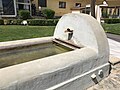
- fountains that also allow access to animals
- dedicated watering places like troughs, often found in the countryside for farm use or as decorations
- rain barrels and similar containers
Tags used in combination
name=* - Name of the watering place
Example photos

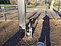
A drinking fountain only for dogs in Málaga, Spain.


.jpg)


_-_Fontaine_de_Font-Loubat.jpg)


Possible rendering
![]() suggested by User:Chrisana13
suggested by User:Chrisana13
See also
- amenity=drinking_water - drinking place for humans. Tag dog=yes indicates a dog water bowl is available as well.
- amenity=fountain - a decorative water feature
- amenity=game_feeding - a game feeding place
- amenity=feeding_place
- Riding
- Proposed features/Watering place - Original proposal page for this tag
Common/possible tagging mistakes