Tag:historic=charcoal_pile
Jump to navigation
Jump to search
 |
| Description |
|---|
| Historic site of a charcoal pile. Often still in good condition in hilly forest areas. |
| Group: historic |
| Used on these elements |
| See also |
| Status: de facto |
| Tools for this tag |
|
The tag historic=charcoal_pile is used for still visible historic sites of ![]() charcoal piles.
charcoal piles.
Tag with a Node or draw the contour Area.
How to survey
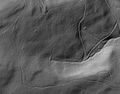
In northern Europe they are often still in good condition in hilly forest areas.
This is a list of indicators, but may vary from region to region:
- The site is a leveled circle or oval, usually 5 to 15 metres in diameter.
- Digging in the ground will reveal black mould, and tiny pieces of charcoal.
- The site is completely free of stone.
- Remains of a hut can often be seen near the perimeter of the site.
- Charcoal pile sites are usually found in areas around iron works.
- The site is near a water source, typically a stream.
- The site is placed so that gases will naturally ventilate away.
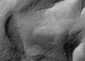
Hills with some charcoal pile sites.
Often the sites are connected by footways, now unused but still traceable.


Sources
Use high resolution Digital Elevation Model images for tracing (e.g. LiDAR images):
- Germany, North Rhine-Westfalia: NRW-Atlas - DGM Schummerung
Related
- If the site is still in use, think about using man_made=charcoal_pile.
- A permanent structure is more likely to be tagged as man_made=kiln.