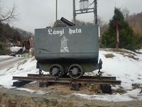
Tag:historic=minecart
Jump to navigation
Jump to search
| Group: historic |
| Used on these elements |
|---|
| Status: undefined |
| Tools for this tag |
|
A tag for ![]() minecart. Mostly find in mining regions, where mining already ended.
minecart. Mostly find in mining regions, where mining already ended.
How to map
Place a node at the location of the minecart and use historic=minecart.
Additional tags
- name=* – The name of the minecart, if it has one.
- inscription=* – Text which is written on minecart.
- operator=* – The (current) operator (i.e., maintainer or exhibitor) of the minecart.
- start_date=* – Start date of mining written on minecart.
- end_date=* – End date of mining written on minecart.
- resource=* – Resource or mineral commodity located inside or related to a minecart.
- tourism=attraction – To mark it as a tourist attraction.
- gauge=* – Standard distance between the rails it ran on.
- description=* – Can be used to provide additional information about the minecart to the map user.
See also
- historic=locomotive A decommissioned locomotive
- historic=railway_car A decommissioned railway car
