Tag:landuse=meadow
Jump to navigation
Jump to search
 |
| Description |
|---|
| An area of meadow or pasture: land primarily vegetated by grass and other non-woody plants, mainly used for hay or grazing. |
| Rendering in OSM Carto |

|
| Group: landuse |
| Used on these elements |
| Useful combination |
| See also |
| Status: de facto |
| Tools for this tag |
|
Used to tag an area of meadow or pasture - land primarily vegetated by grass plus other non-woody plants, mainly used for hay (meadow) or for grazing animals (pasture).
How to map
Draw a way around the area of the meadow, and tag landuse=meadow.
Tags in combination
If the meadow or pasture has a name, add name="name of meadow".
The key meadow=* has been used to indicate the process that protects the meadow status, or the kind of meadow.
- meadow=agricultural a hay meadow or pasture, maintained by cutting, mowing or grazing.
- meadow=transitional an area of grass which is transitioning to heath, scrub or woodland.
- meadow=perpetual a "meadow" which is retained by natural factors. (It is more common to use natural=grassland in this case)
- meadow=pasture a pasture for grazing livestock (not a hay meadow).
- meadow=paddock an area of grass where horses or other animals are kept
- meadow=meadow_orchard an area which is both an orchard (with trees grown for fruit or nuts) and a meadow. (Also see orchard=meadow_orchard + landuse=orchard)
- meadow=wildflower A wildflower meadow. It serves primarily as a habitat for insects and for nature conservation rather than for the production of grass and hay. It is also usually regularly mown.
Photos
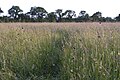
Long grassy meadow
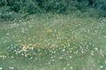
Cut meadow

.jpg)
Rendering example

See also
- landuse=farmland - An area of farmland used for tillage (cropland). This tag is sometimes also used for pasture or meadow.
- landuse=grass - An area of mown and managed grass, e.g. a lawn in a park, part of a golf course, roadside verges etc.
- surface=grass - To indicate the surface of a specific use feature e.g. leisure=pitch
- landcover=grass.
- natural=grassland - An area of non-cultivated grassland.
- natural=scrub - A plant community characterized by vegetation dominated by shrubs (bush) More woody plants than a meadow or grassland.
- natural=heath - A dwarf-shrub habitat, characterised by open, low growing woody vegetation, often dominated by plants of the Ericaceae. More woody plants than a meadow or grassland.
- Vegetation - summary of tags related to areas of vegetation of different types
Tagging mistakes
External links
| ||||||||||||||||||||||||||||||||