Tag:natural=heath
 |
| Description |
|---|
| A dwarf-shrub habitat, characterised by open, low growing woody vegetation, often dominated by plants of the Ericaceae. |
| Rendering in OSM Carto |

|
| Group: natural |
| Used on these elements |
| Useful combination |
| See also |
| Status: de facto |
| Tools for this tag |
|
The tag natural=heath is used to map areas of heath or heathland: a dwarf-shrub habitat, characterized by open, low-growing woody vegetation, often dominated by plants of the Ericaceae (Heather). The tag natural=heath can be applied to any similar habitat worldwide.[1]
How to map
Draw an area and add natural=heath.
Mapping caveats
This tag should not be used for:
- parks which happen to be named "something heath" (e.g., "Hampstead Heath"; quite common in England). A park should be tagged leisure=park, leisure=nature_reserve or boundary=protected_area as appropriate, even if it has "heath" in the name. Only if it is genuinely a heath fitting the description above (and not primarily regarded as a normal public park) then use this tag.
- areas dominated by taller shrubs – use natural=scrub instead.
- areas primarily covered by herbaceous (non-woody) plants like grasses – use natural=grassland or landuse=meadow, if used for grazing, instead.
Examples
Here are various examples from different ecosystems – what can be seen in the foreground in those can commonly be mapped as natural=heath.
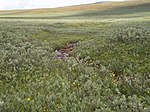
Subarctic ground willow (Salix brachycarpa), northern Finland
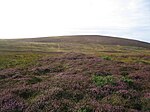
Heather at Achadh na Gaodha in Scottish Highlands
Heath at Bredfjäll near Göteborg, Sweden

Sagebrush steppe of Río Negro Province, Argentina

Sagebrush steppe in Nevada, U.S.

Garrigue of Southern France

Phrygana in central Crete, Greece


See also
Possible tagging mistakes
Notes
External links
- See Heath on Wikipedia
| ||||||||||||||||||||||||||||||||