Tag:natural=fell
 |
| Description |
|---|
| Habitat above tree line covered with grass, dwarf shrubs and mosses. |
| Group: natural |
| Used on these elements |
| Useful combination |
| See also |
| Status: de facto |
| Tools for this tag |
|
Habitat above tree line in alpine and subpolar regions, principally covered with uncultivated grass, low growing shrubs and mosses and sometimes grazed.
See fell on Wikipedia
"A fell (from Old Norse fell, fjall, "mountain") is a high and barren landscape feature, such as a mountain range or moor-covered hills. The term is most often employed in Scandinavia, the Isle of Man, parts of northern England, and Scotland." Also located in Canada, Russia, Spitsbergen, Iceland and Greenland.
In the north of England, and probably in other areas of Norse influence such as Iceland, Norway and Sweden, there is a practice of naming the sides of hills, fells, rather than peaks. A single hill can have different names on different sides. This tag can be used to record such names.
Meaning of this tag overlaps with natural=tundra.
Actual use of the tag for areas as of October 2017 includes different kinds of treeless areas, in particular areas vegetated primarily by grasses (Poaceae) which are commonly tagged as natural=grassland or landuse=meadow, areas mostly vegetated by dwarf scrubs which are more commonly tagged natural=heath, rain fed peat producing wetlands for which the established tagging is natural=wetland + wetland=bog and areas with very little or no vegetation which in most cases qualify as natural=scree or natural=bare_rock. When mapping preferably choose the tag that best and most precisely describes the specific setting you are looking at rather than natural=fell. Data users should not expect a particular type of surface or vegetation for areas tagged natural=fell.
Tagging
| Tag | Description | Example |
|---|---|---|
| name=* | Name of site. |
Rendering
| OSM Carto | OpenCycleMap |
|---|---|
| No, see #545. | No. |
See also
Examples

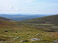
Sarek National Park, Sweden
View from Dundret mountain, Gällivare, Sweden

Rapadalen i Sarek, Sweden
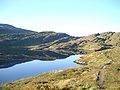
Vikafjell, Norway
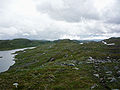
Setesdal Vesthei, Norway

Summit ridge of the mountain Place Fell, England


| ||||||||||||||||||||||||||||||||