Tag:natural=spring
 |
| Description |
|---|
| A place where ground water flows naturally from the ground |
| Rendering in OSM Carto |
| Group: natural |
| Used on these elements |
| Useful combination |
|
| See also |
| Status: de facto |
| Tools for this tag |
|
A ![]() spring is a locally limited area where groundwater discharges at the surface from an underground aquifer.
spring is a locally limited area where groundwater discharges at the surface from an underground aquifer.
Springs are features located mostly in hilly or mountainous environments, where the discharge may have a wide range from millilitres to several cubic metres per second. Karst springs in particular are impressive due to their seasonally high discharge, like the Fontaine de Vaucluse. Some have major importance as the headwaters of streams and rivers. Especially in dry areas, springs are traditionally prominently marked on topographic maps.
Some springs may have a man-made water basin or fountain to provide drinking water. In this case drinking_water=yes and refitted=yes may be added.
For a structural installation which is designed and built for catching groundwater from a natural spring for water supply see man_made=spring_box.
How to Map
Add a node ![]() at the centre and tag it with natural=spring. The area
at the centre and tag it with natural=spring. The area ![]() can be drawn for large springs.
can be drawn for large springs.
Use natural=water if there is a significant water pool around the spring.
Hot Springs
natural=hot_spring has been proposed for hot springs and although not approved the feature description has been marked as "de facto" since December 2015. According to Wikipedia there is no universally accepted definition of a hot spring[1], instead it should be mapped as hot_spring if it is locally known as hot or thermal spring.
Another documented tagging scheme for hot springs for recreational use is a public bath with bath:type=hot_spring.
Tags to use in combination
- name=*
- drinking_water=yes/no Indication whether a feature provides drinking water.
- drinking_water:legal=yes/no the water is checked and approved by public authorities
- seasonal=no/yes/winter/wet_season/... Indication whether the spring is active only in a certain season.
Karstic springs
A spring can be part of a karst system: its water may come from ponors or estavelles, and from several of them. If so, tag the spring also with karst=yes; that would model the spring as karstic, meaning that it throughput and the quality of its water may greatly vary. You may also want to map the relation between it and the other members of the karst system; if so, please read sinkhole=* to know how.
Proposed additions
Use water_characteristic=* to specify mineral, gas or other content if notable. This could be multivalued, but usually there is a main name giving characteristic which should the first value. See Proposed features/Hot Spring for details. Main values (please amend):
- mineral - mineral salts
- sulfuric
- radon
- mud
- mineral, hot water, salty spring
- intermittent or perennial
- discharge
- chalybeate - iron salts
Examples
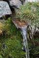
A little spring in Tyrol
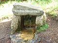
Spring capture in Germany

A natural spring on Mackinac Island in Michigan
Spring for watering livestock, see amenity=watering_place

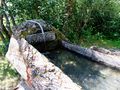
Spring of Vaucluse in France

the spring at the house of Choi Cham-pan in Hadong, Korea


.jpg)
Quality assurance
- overpass turbo code to render drinking_water=* as colour coded - black/missing, blue/yes, red/no, orange/conditional and for refitted=* text value (yes, no or missing)
Potential tagging mistakes
See also
- natural=hot_spring - A spring of geothermally heated groundwater
- natural=geyser - A spring characterized by intermittent discharge of water ejected turbulently and accompanied by steam.
- amenity=drinking_water - A place to get "drinking water" in smaller amounts for personal usage (hiking, spa, ...).
- amenity=fountain - A fountain for cultural / decorational / recreational purposes.
- man_made=spring_box - A structure built for catching groundwater from a natural spring for water supply
- natural=cave_entrance - Some springs, especially resurgence are also caves.
- man_made=water_well - A structural facility to access groundwater from an aquifer, created by digging or drilling.
- sinkhole=* - A spring may be part of a karst system, made of several sinkholes and spring interconnected by underground water flows.
- amenity=watering_place - A place where animals can drink water