Tag:service=parking_aisle
 |
| Description |
|---|
| a subordinated way in a parking lot between rows of parking spaces that vehicles use to drive into and out of the spaces. |
| Rendering in OSM Carto |

|
| Group: highways |
| Used on these elements |
| Requires |
| Useful combination |
|
| Status: approved |
| Tools for this tag |
|
A parking aisle is a service road that passes between rows of parking spaces (amenity=parking_space) in a parking lot or parking garage (amenity=parking or possibly amenity=motorcycle_parking), providing direct access for a motorized vehicle to enter and leave a parking space. It is generally not used for through traffic.
How to map
Use this tag in conjunction with highway=service on a parking aisle. Draw the way running down the center of the parking aisle, roughly equidistant from the two adjacent rows of parking spaces.
Add oneway=yes if cars can only travel in a single direction without going into reverse gear. When tracing from aerial imagery, a parking aisle may be one-way if:
- Arrows painted on the pavement at either end of the parking aisle are all pointed in the same direction. (However, arrows may appear on the pavement for other reasons, such as to direct drivers to a drive-through.)
- The parking aisle isn't particularly wide, and all the parking spaces on both sides are angled to provide easy access coming from one direction but not the other. (However, in some localities, back-in angle parking is common.)
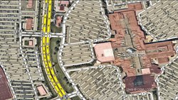
- One-way parking aisles
-
 One-way parking aisles marked by arrows on the pavement
 -
 One-way parking aisles also implied by angled parking spaces


Parking aisles can be reserved for vehicles other than passenger cars, so use the same access tags as the amenity=parking area. For example, the parking aisles in a bus depot would be tagged motorcar=no bus=designated. A parking lot that is reserved for private use and has a "no trespassing" sign would be tagged access=private.
If you are mapping the parking aisles within a parking garage (amenity=parking parking=multi-storey), add tags such as covered=yes, level=*, and layer=* as needed.
It is common for a fast food restaurant's drive-through (service=drive-through) be nothing more than a painted lane in a parking aisle, with parking spaces to either side. Since the drive-through may pass to the left of oncoming traffic, some mappers treat this situation as an exception to the "physical separation" rule and map the drive-through and parking aisle as two separate ways.
- Drive-throughs as lanes in a parking aisle
-
 A McDonald's restaurant in France
 -
 A McDonald's restaurant in Poland
 -
 A Chick-fil-A restaurant in the United States


Disambiguation

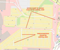
Not every roadway within a parking lot is a parking aisle. Examples are...
- Road connects a parking lot or parking garage to a through street and serves as the entrance or exit of the lot or garage – use
highway=servicewithoutservice=*instead. - Forms the "trunk" or perimeter of the parking lot, connecting multiple parking aisles – use
highway=servicewithoutservice=*instead. There may be parking spaces on either side, but the roadway's primary purpose is to get drivers to another part of the parking lot. - Roadway does not have any parking bays itself.
- Primarily provides space for picking up and dropping off passengers – use
highway=serviceservice=drivewayinstead.
Also avoid this tag in the following situations:
- A normal through road that happens to have on-street parking – use street parking tags in this case.
- An access road that primarily serves a bus station (
amenity=bus_station), taxi stand (amenity=taxi) or carpooling station (amenity=car_pooling) – usehighway=servicewithservice=drivewayor withoutservice=*. - A driveway that primarily provides direct access to a house, garage, or carport, even if a small number of parking spots is available for occupants – use
highway=serviceservice=drivewayinstead. - An aisle in a large bicycle parking area (
amenity=bicycle_parking) – usehighway=footwayorhighway=cyclewayinstead.
Examples
-
-
 Common tagging errors

Software support

Renderers
The Standard tile layer renders parking aisles at zoom levels 16 and higher as lines that are thinner than ways tagged with only highway=service.
Mapbox styles show parking aisles, but styles such as Navigation Preview Day omit colour-coded traffic congestion along parking aisles to avoid clutter and inaccurate telemetry data on low-volume roads.
Routers
As with other kinds of highway=service ways, routers such as OSRM and Valhalla route over parking aisles but generally avoid using them as shortcuts between higher-classed roads. OSRM's default driving profile penalizes parking aisles more than ways tagged with only highway=service – by the same factor as alleys, driveways, and drive-throughs. [1] In the usual case where a parking aisle is unnamed, guidance instructions may substitute a generic word.
In 2019, Tesla owners reported that the car's Smart Summon feature could be influenced by parking aisles in OSM. [2]
Possible tagging mistakes
See also
amenity=parking- Parking
- Street parking
barrier=*Are there fences/stones hindering free roaming on an empty parking area?- Proposal of this feature